Webster, Texas
| Webster, Texas | |
|---|---|
| City | |
|
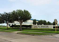
Webster City Hall and Police Department | |
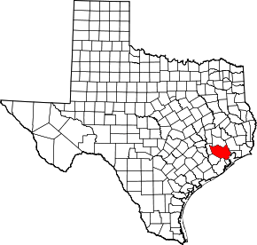
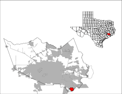 Location of Webster, Texas | |
| Coordinates: 29°32′19″N 95°7′10″W / 29.53861°N 95.11944°WCoordinates: 29°32′19″N 95°7′10″W / 29.53861°N 95.11944°W | |
| Country | United States |
| State | Texas |
| County | Harris |
| Area | |
| • Total | 6.6 sq mi (17.0 km2) |
| • Land | 6.3 sq mi (16.4 km2) |
| • Water | 0.2 sq mi (0.6 km2) |
| Elevation | 26 ft (8 m) |
| Population (2010) | |
| • Total | 10,400 |
| • Density | 1,600/sq mi (610/km2) |
| Time zone | Central (CST) (UTC-6) |
| • Summer (DST) | CDT (UTC-5) |
| ZIP code | 77598 |
| Area code(s) | 281 |
| FIPS code | 48-76948[1] |
| GNIS feature ID | 1349594[2] |
| Website |
www |
Webster is a city in the U.S. state of Texas located in Harris County, within the Houston–Sugar Land–Baytown metropolitan area. The population was 10,400 at the 2010 census.[3]
History
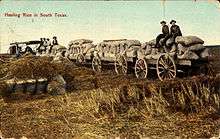
The community was founded in 1879 by James W. Webster under the name Gardentown. It was established initially as a colony for settlers from England. It began as a stopover for travelers between Houston/Harrisburg, Galveston, Kemah, and Seabrook. Eventually railroads, such as the Missouri, Kansas and Texas Railway, were built through the area. Farmers in the area raised pears and other produce.[4]
In 1903, the Houston Chamber of Commerce invited Seito Saibara, a former Japanese member of parliament and a Christian theologian, to come to Texas to teach rice farming. Rice at that time was emerging as an important cash crop. Saibara settled in Webster and established a small farming community of Japanese Christians. Saibara and his son Kiyoaki established the foundations of what became the rice industry of the U.S. Gulf Coast.[5][6]
Dairies and livestock ranches developed in the town as well in the early 1900s. Petroleum was discovered at the Webster-Friendswood Oilfield in the 1930s, but the population remained small. The community was incorporated in 1958.[4]
In 1961 the National Aeronautics and Space Administration announced that it was building the Manned Spacecraft Center (now known as the Johnson Space Center) nearby along the shores of Clear Lake. Growth and development quickly swept over the Clear Lake Area, and Webster's population blossomed.[4] Webster today has become a thriving bedroom community closely tied to the Clear Lake Area and its high-tech industry.
Geography

Webster is located at 29°32′19″N 95°07′10″W / 29.538581°N 95.119354°W (29.538581, -95.119354).[7]
According to the United States Census Bureau, the city has a total area of 6.6 square miles (17.0 km2), of which 6.3 square miles (16.4 km2) is land and 0.23 square miles (0.6 km2), or 3.24%, is water.[8]
Climate
The climate in this area is characterized by hot, humid summers and generally mild to cool winters. According to the Köppen Climate Classification system, Webster has a humid subtropical climate, abbreviated "Cfa" on climate maps.[9]
Demographics
| Historical population | |||
|---|---|---|---|
| Census | Pop. | %± | |
| 1960 | 329 | — | |
| 1970 | 2,231 | 578.1% | |
| 1980 | 2,405 | 7.8% | |
| 1990 | 4,678 | 94.5% | |
| 2000 | 9,083 | 94.2% | |
| 2010 | 10,400 | 14.5% | |
| Est. 2015 | 11,116 | [10] | 6.9% |
As of the census[1] of 2000, there were 9,083 people, 4,114 households, and 1,970 families residing in the city. The population density was 1,372.9 people per square mile (529.8/km2). There were 4,733 housing units at an average density of 715.4 per square mile (276.0/km2). The racial makeup of the city was 64.85% White, 9.03% African American, 0.55% Native American, 5.72% Asian, 0.15% Pacific Islander, 15.78% from other races, and 3.92% from two or more races. Hispanic or Latino of any race were 27.24% of the population.
There were 4,114 households out of which 24.6% had children under the age of 18 living with them, 32.7% were married couples living together, 10.1% had a female householder with no husband present, and 52.1% were non-families. 40.6% of all households were made up of individuals and 2.1% had someone living alone who was 65 years of age or older. The average household size was 2.14 and the average family size was 2.97.
In the city the population was spread out with 20.9% under the age of 18, 15.0% from 18 to 24, 43.5% from 25 to 44, 15.4% from 45 to 64, and 5.1% who were 65 years of age or older. The median age was 29 years. For every 100 females there were 109.3 males. For every 100 females age 18 and over, there were 107.3 males.
The median income for a household in the city was $42,385, and the median income for a family was $43,495. Males had a median income of $35,346 versus $29,808 for females. The per capita income for the city was $21,964. About 12.5% of families and 13.2% of the population were below the poverty line, including 19.2% of those under age 18 and 5.6% of those age 65 or over.
Government and infrastructure

The City of Webster has two fire stations, Station #1 and Station #2, with the fire department offices in the second station.[12]
The City of Webster has its own police department.
The Texas Department of Public Safety (DPS) operates its Webster Field Investigator Office and its Webster Driver's License Office in a nearby area in Houston.[13][14]
The Texas Department of Criminal Justice (TDCJ) operates the Webster District Parole Office in a nearby area in Houston.[15]
The United States Postal Service Webster Post Office is located at 17077 North Texas Avenue.[16]
Economy
The Baybrook Mall is physically located in the City of Houston.[17] The mall is in proximity to Webster.[18]
Education

Primary and secondary schools
Public schools
Pupils in Webster attend schools in Clear Creek Independent School District. The community is divided between the Board of Trustee District 2 and the Board of Trustee District 4.[19][20] They are represented by Win Weber and Stuart J. Stromeyer, respectively, as of 2008.[21]
Residents are zoned to either McWhirter Elementary School (Webster) or P.H. Greene Elementary School (Friendswood).
Some residents are zoned to Clear Creek Intermediate School (League City), and some residents are zoned to Space Center Intermediate School (Houston).
All residents are zoned to either Clear Springs High School, Clear Creek High School, or Clear Brook High School.
Webster Intermediate School formerly served the city but moved to an unincorporated area near Friendswood and was renamed Westbrook Intermediate School in Spring 2005; Westbrook does not serve Webster as of 2006.[22]
There are other sections of Webster zoned to other schools, but there are no residents in those sections.
Private schools
Iman Academy Southeast Secondary School is located in Webster off of Highway 3.[23]
Parks and recreation
The Edgar A. Smith Family YMCA is located in Webster. (note: this YMCA is in the city of Houston. Served by Webster post office)
Notable people
- Dennis Paul, Republican member of the Texas House of Representatives from District 129, formerly resided in Webster
- Steve Stockman, Republican former member of the United States House of Representatives from Texas's 36th congressional district
- Josh Huestis, Basketball Player for the Oklahoma City Thunder
- Ryan Trecartin, multimedia artist
See also
References
- 1 2 "American FactFinder". United States Census Bureau. Retrieved 2008-01-31.
- ↑ "US Board on Geographic Names". United States Geological Survey. 2007-10-25. Retrieved 2008-01-31.
- ↑ "Profile of General Population and Housing Characteristics: 2010 Demographic Profile Data (DP-1): Webster city, Texas". U.S. Census Bureau, American Factfinder. Retrieved June 26, 2012.
- 1 2 3 Kleiner, Diana J.: Webster, Texas from the Handbook of Texas Online. Retrieved 26 January 2010. Texas State Historical Association.
- ↑ "History of Webster, Texas". City of Webster. Retrieved 26 January 2010.
- ↑ Saibara, Seito from the Handbook of Texas Online. Retrieved 26 January 2010. Texas State Historical Association.
- ↑ "US Gazetteer files: 2010, 2000, and 1990". United States Census Bureau. 2011-02-12. Retrieved 2011-04-23.
- ↑ "Geographic Identifiers: 2010 Demographic Profile Data (G001): Webster city, Texas". U.S. Census Bureau, American Factfinder. Retrieved June 26, 2012.
- ↑ Climate Summary for Webster, Texas
- ↑ "Annual Estimates of the Resident Population for Incorporated Places: April 1, 2010 to July 1, 2015". Retrieved July 2, 2016.
- ↑ "Census of Population and Housing". Census.gov. Retrieved June 4, 2015.
- ↑ "Public Information Phone Numbers." City of Webster. Retrieved on May 16, 2010.
- ↑ "Field Investigator Offices." Texas Department of Public Safety. Retrieved on May 16, 2010.
- ↑ "Texas Driver License Office Map." Texas Department of Public Safety. Retrieved on May 16, 2010.
- ↑ "Parole Division Region III." Texas Department of Criminal Justice. Retrieved on May 15, 2010.
- ↑ "Post Office Location - WEBSTER." United States Postal Service. Retrieved on December 6, 2008.
- ↑ "SN_81.pdf" (Archive). Retrieved on March 31, 2014.
- ↑ Kaplan, David. "Major expansion set for Baybrook Mall." Houston Chronicle. March 24, 2014. Retrieved on March 31, 2014. "The company that owns the indoor shopping complex off the Gulf Freeway in suburban Webster will add 555,000 square feet of retail, restaurant and entertainment space and create a community lawn the length of a football field."
- ↑ District 2 Map. Clear Creek Independent School District. Retrieved on December 6, 2008.
- ↑ District 4 Map. Clear Creek Independent School District. Retrieved on December 6, 2008.
- ↑ "School Board Members: Bios and Contact Information." Clear Creek Independent School District. Retrieved on December 6, 2008.
- ↑ Hunter, Rachel. "Changes to attendance zones approved." Galveston County Daily News. February 26, 2005. Retrieved on March 31, 2014. "The district is closing Webster Intermediate at the end of the school year and a replacement campus, Westbrook Intermediate, is scheduled to open in August, Taylor said. Although Westbrook is a new campus, she said, it is simply replacing Webster, which will become an alternative school for students at risk of failing or dropping out. Taylor said the replacement campus would not provide the district with additional space for intermediate school students, but attendance zones needed to be changed to include the new campus."
- ↑ "Contact Us." Iman Academy. Retrieved on November 14, 2010.
External links
| Wikimedia Commons has media related to Webster, Texas. |
| Large cities |  | |
|---|---|---|
| Other cities | ||
| CDPs and non- municipalities | ||
| Counties | ||
| Subregions | ||
| Bodies of water | ||
| Major ports | ||
| Nature preserves | ||
| Counties | 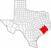 | |
|---|---|---|
| "Principal" cities | ||
| Other cities |
For a complete listing, see list of cities and towns in Houston–The Woodlands–Sugar Land MSA | |
| Unincorporated areas | ||
| Bodies of water | ||