Thames Path
| Thames Path | |
|---|---|
|
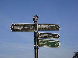
The Thames Path sign at the end of the walk, by the Thames Barrier | |
| Length | 184 mi (296 km) |
| Location | Southern England, United Kingdom |
| Designation | UK National Trail |
| Trailheads | Kemble, Gloucestershire and Thames Barrier, Charlton, London |
| Use | Hiking, cycling |
| Hiking details | |
| Trail difficulty | Easy |
| Season | All year |

The Thames Path is a National Trail following the River Thames from its source near Kemble in Gloucestershire to the Thames Barrier at Charlton, south east London. It is about 184 miles (296 km) long.[1] A path was first proposed in 1948 but it only opened in 1996.[2]
The path's entire length can be walked, and some parts can be cycled. Most of the path is on the original towpath but in some places it is not possible at several points where towpath traffic crossed the river using ferries.[3] but apart from Shepperton to Weybridge Ferry The ferries no longer operate and in places such as Shiplake, Whitchurch-on-Thames and Moulsford, there are diversions away from the towpath. At other places, there are replacement connections such as at Hurley, where the Temple Footbridge was built in 1989.
Some parts of the Thames Path, particularly west of Oxford, are subject to flooding during the winter. The river is tidal downstream from Teddington Lock, and parts of the path may be under water if there is a particularly high tide.
The Thames Path Cycle Route is a black-signposted route that follows the river between Putney Bridge in the west and Greenwich in the east. It mostly follows the Thames Path, but diverges in various sections, especially where the path follows a footpath-only route. It also links National Cycle Route 1 (east of London) with National Cycle Route 4 (west of London).[4]
Route
The route can be divided into these sections:
- Thames Head (source of the river west of Cricklade) to Oxford (54 mi or 87 km): a generally rural, agricultural area, where the river is sometimes difficult to follow, particularly until Lechlade (23 mi or 37 km).
- Oxford to Henley-on-Thames (51 mi or 82 km): passing through Abingdon, Dorchester, Wallingford, Streatley and Reading: the walk leaves the river bank through the towns, and crosses from one bank to another at various places.
- Henley to Windsor: (23 mi or 37 km): through Marlow and Maidenhead. The path leaves the river in some places.
- Windsor to Richmond (28 mi or 45 km): along the edge of Windsor Great Park; past Runnymede; through Hampton Court Park. The path leaves the river to for some residential areas.
- Richmond to the Thames Barrier (28 mi or 45 km): Passing Kew Gardens and the Wetlands Centre at Barnes then through London, using parkland (e.g., Battersea Park) to continue beside the river. Through most of the section, the Thames Path is actually two paths, one on either side of the river.
- Thames Barrier to Crayford Ness, just beyond Erith (10 mi or 16 km), connecting with the London Outer Orbital Path. This is considered an extension of the Thames Path (as recognised by the Ramblers Association) and was opened in 2001, but is not part of the National Trail. It has its own Thames Barge symbol, and is sometimes referred to as the Thames Path Southeast Extension.
The path is one of the Mayor of London's Strategic walking routes.
Thames crossings

The list below shows the points going downstream where the path crosses the river between Cricklade and Teddington. Above Cricklade the Thames is a stream and in some places there may be no water except after rain. Below Teddington there are paths on both sides of the river until the Greenwich foot tunnel, after which the path is only on the south. The letter in brackets indicates whether the path downstream of that point is on the northern or southern bank (using north or south in reference to the river as a whole, rather than at that specific point). Bridges and ferries are listed in full under Crossings of the River Thames. Islands are listed under Islands in the River Thames.
- Cricklade (S)
- Eysey Footbridge (N)
- Water Eaton House Bridge (S)
- Bloomers Hole Footbridge (N)
- Radcot Bridge (S)
- Tadpole Bridge (N)
- Tenfoot Bridge (S)
- Newbridge, Oxfordshire (N)
- Pinkhill Lock (S)
- Fiddler's Island (N)
- Osney Bridge (S)
- Abingdon Lock (N)
- Clifton Hampden Bridge (S)
- Day's Lock (N)
- Benson Lock (S)
- Goring and Streatley Bridge (N)
- Whitchurch Bridge (S)
- Sonning Bridge (N)
- Henley Bridge (S)
- Temple Footbridge (N)
- Bourne End Railway Bridge (S)
- Maidenhead Bridge (N)
- Windsor Bridge (S)
- Victoria Bridge, Datchet (N)
- Albert Bridge, Datchet (S)
- Staines Bridge (N)
- Shepperton to Weybridge Ferry (S)
- Hampton Court Bridge (N)
- Kingston Bridge, London (S)
- Teddington Lock Footbridges
The reverse direction of the path going upstream on the non-tidal part is obtainable by following the locks up from Teddington Lock. Between Teddington Lock and Lechlade the locks divide the river into reaches and a description of the reach above each lock includes the route of the Thames Path going upstream. Locks are listed under Locks on the River Thames.
Notes and references
- ↑ "Thames Path". National Trails. Retrieved 18 May 2016.
- ↑ "Thames Path - Ramblers". www.ramblers.org.uk. Retrieved 24 November 2014.
- ↑ Fred. S. Thacker The Thames Highway: Volume II Locks and Weirs 1920 – republished 1968 David & Charles
- ↑ http://www.bexley.gov.uk/index.aspx?articleid=3185
External links
| Road |
| ||||||||||||||||||
|---|---|---|---|---|---|---|---|---|---|---|---|---|---|---|---|---|---|---|---|
| Rail |
| ||||||||||||||||||
| Air | |||||||||||||||||||
| Waterways |
| ||||||||||||||||||
| Footpaths | |||||||||||||||||||
| Cycle Paths | |||||||||||||||||||
| Related articles | |||||||||||||||||||

Coordinates: 51°40′N 1°15′W / 51.667°N 1.250°W