Thebarton, South Australia
| Thebarton Adelaide, South Australia | |||||||||||||
|---|---|---|---|---|---|---|---|---|---|---|---|---|---|
| Population | 1,322 (2011 census)[1] | ||||||||||||
| Established | 1839[2] | ||||||||||||
| Postcode(s) | 5031 [3] | ||||||||||||
| Location | 2 km (1 mi) W of Adelaide | ||||||||||||
| LGA(s) | City of West Torrens | ||||||||||||
| State electorate(s) | West Torrens | ||||||||||||
| Federal Division(s) | Adelaide | ||||||||||||
| |||||||||||||
Thebarton (/ˈθɛbərtən/ THEB-ər-tən) is a suburb of the city of Adelaide, South Australia. The suburb is bounded by the River Torrens to the north, Port Road and Bonython Park to the east, Kintore Street to the south, and South Road to the west.
Many buildings and landmarks that bear the name of Thebarton are actually in the adjoining suburb of Torrensville, including Thebarton Oval, the Thebarton croquet and bowls club, Thebarton Theatre, and Thebarton Senior College. The historic Adelaide Gaol, nominally shown as being in Thebarton, and the adjacent Thebarton Barracks of the South Australia Police actually lie within the northwestern Adelaide Park Lands.
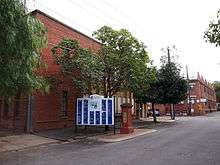
The Thebarton campus of the University of Adelaide, also known as Adelaide University Research Park, occupies a complex of former industrial buildings in the northeastern corner of the suburb.

History
Prior to European settlement, the areas now known as Thebarton and Hindmarsh were called Karraundongga (meaning "red gum spear place") by the Kaurna people, who would craft spears from the red gum branches gathered on the banks of the Torrens there.[4]
The suburb of Thebarton was named after the home of Colonel William Light, the first Surveyor-General of the colony of South Australia. Colonel Light named his home after Theberton Hall of Suffolk, England, where he was educated. The variant spelling is accredited to a typographical error. The area was known as Theberton until approximately 1840.
Colonel Light surveyed the town-acre as Section 1 and built Theberton Cottage towards the northern part of the area. The area was first subdivided for housing in February 1839, although it took a number of years for the housing to establish, Thebarton Post Office opening on 24 October 1850.[5] By 1866 the population was estimated at around 450 people.
Thebarton has a significant Greek-Australian population and is the suburb with the largest Greek Australian population per capita in Australia. In fact, according to census data released by the Australian Bureau of Statistics in 2001, the suburbs of Thebarton and neighbouring Torrensville together are home to 4,471 Greek-Australians; i.e., 18.7 per cent of the total population.
Government
Thebarton was part of the then largely rural District of West Torrens until 1883, when the residents of the more urban suburbs of Thebarton, Mile End and Torrensville successfully petitioned to become the Corporation of the Town of Thebarton.[4] In 1997 the Town of Thebarton re-amalgamated with the City of West Torrens.[6]
Landmarks

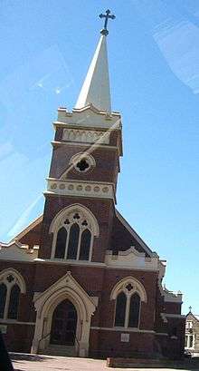
- St. George Greek Orthodox Church, Adelaide's largest Greek Orthodox church
- The Ice Arena, home of the Adelaide Adrenaline, who play in the Australian Ice Hockey League
- The Adelaide Gaol
- Thebarton Oval, former home of the West Torrens Football Club in the South Australian National Football League. Now home to the South Australian Amateur Football League.
- The Thebarton Incinerator, designed by Walter Burley Griffin in 1935,[7] completed in 1937, and decommissioned in 1964,[8] is one of his two buildings in SA listed as among the 120 nationally significant 20th-century buildings in South Australia,[9] the other being the Hindmarsh Incinerator at Brompton.
Heritage listings
Thebarton has a number of heritage-listed sites, including:
- 39A Dew Street: Lady Gowrie Child Centre [10]
- 1 George Street: Squatters Arms Hotel [11]
- 42 and 42A Phillips Street: Thebarton Baptist Church and Hall [12]
- 77 Port Road: Southwark Hotel [13] (pronounced /ˈsʌðərk/)
- 35-37 Stirling Street: Faulding's Eucalyptus Oil Distillery [14]
- 34-36 West Thebarton Road: Thebarton Incinerator [15]
References
- ↑ Australian Bureau of Statistics (31 October 2012). "Thebarton (State Suburb)". 2011 Census QuickStats. Retrieved 28 April 2014.
- ↑ Place names of South Australia The Manning Index of South Australian History. State Library of South Australia. Retrieved 28 April 2014.
- ↑ Australia Post - Postcode:Thebarton, SA (28 April 2014)
- 1 2 Payne, P. (1996): Thebarton, Old and New. Thebarton City Council. ISBN 0 646 30157 8
- ↑ Premier Postal History. "Post Office List". Premier Postal Auctions. Retrieved 26 May 2011.
- ↑ City of WestTorrens > Local history > Story of West Torrens Accessed 28 April 2014.
- ↑ Building Details - Architects of South Australia > Thebarton Incinerator Accessed 13 May 2014.
- ↑ Payne & pp.138–140.
- ↑ 120 notable buildings - Australian Institute of Architects Accessed 8 May 2014.
- ↑ "Lady Gowrie Child Centre". South Australian Heritage Register. Department of Environment, Water and Natural Resources. Retrieved 11 September 2016.
- ↑ "Squatters Arms Hotel". South Australian Heritage Register. Department of Environment, Water and Natural Resources. Retrieved 11 September 2016.
- ↑ "Squatters Arms Hotel". South Australian Heritage Register. Department of Environment, Water and Natural Resources. Retrieved 11 September 2016.
- ↑ "Former Thebarton Baptist Church & Hall". South Australian Heritage Register. Department of Environment, Water and Natural Resources. Retrieved 11 September 2016.
- ↑ "Southwark Hotel". South Australian Heritage Register. Department of Environment, Water and Natural Resources. Retrieved 11 September 2016.
- ↑ "Former Thebarton Incinerator designed by Walter Burley Griffin". South Australian Heritage Register. Department of Environment, Water and Natural Resources. Retrieved 11 September 2016.
External links
- Geoscience Australia
- South Australian State Gazetteer: Placenames Online
- The Manning Index of South Australian History
Coordinates: 34°54′S 138°34′E / 34.900°S 138.567°E