Thomastown, Mississippi
| Thomastown, Mississippi | |
|---|---|
| Unincorporated community | |
 Thomastown, Mississippi  Thomastown, Mississippi | |
| Coordinates: 32°51′50″N 89°40′10″W / 32.86389°N 89.66944°WCoordinates: 32°51′50″N 89°40′10″W / 32.86389°N 89.66944°W | |
| Country | United States |
| State | Mississippi |
| County | Leake |
| Elevation | 410 ft (120 m) |
| Time zone | Central (CST) (UTC-6) |
| • Summer (DST) | CDT (UTC-5) |
| ZIP code | 39171 |
| Area code(s) | 601 & 769 |
| GNIS feature ID | 678685[1] |
Thomastown is an unincorporated community in Leake County, Mississippi, United States. Thomastown is located at the junction of Mississippi Highway 43 and Mississippi Highway 429 11.9 miles (19.2 km) northwest of Carthage.[2] Thomastown has a post office with ZIP code 39171, which opened on May 17, 1933.[3][4]
References
- ↑ "Thomastown". Geographic Names Information System. United States Geological Survey.
- ↑ Leake County, Mississippi General Highway Map (PDF) (Map). Mississippi Department of Transportation. 2011. Retrieved April 8, 2012.
- ↑ United States Postal Service (2012). "USPS - Look Up a ZIP Code". Retrieved 2012-02-15.
- ↑ "Postmaster Finder - Post Offices by ZIP Code". United States Postal Service. Retrieved April 8, 2012.
Municipalities and communities of Leake County, Mississippi, United States | ||
|---|---|---|
| City | 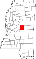 | |
| Towns | ||
| CDPs | ||
| Communities | ||
| Footnotes | ‡This populated place also has portions in an adjacent county or counties | |
This article is issued from Wikipedia - version of the 7/30/2016. The text is available under the Creative Commons Attribution/Share Alike but additional terms may apply for the media files.