Thomson River (Victoria)
| Thomson (Tambo,[1] Carrang-carrang,[2] Carran-carran[3]) | |
| River[4] | |
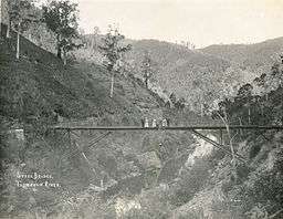
 A bridge over the Thomson River, pictured in 1910. | |
| Name origin: In honour of Sir Edward Thomson[5][6] | |
| Country | Australia |
|---|---|
| State | Victoria |
| Regions | South East Coastal Plain (IBRA), West Gippsland |
| Local government area | Shire of Wellington |
| Part of | West Gippsland catchment |
| Tributaries | |
| - left | Matlock Creek, Jordan River, Aberfeldy River, Stringers Creek, Lammers Creek, Stoney Creek, Macalister River |
| Settlements | Heyfield, Sale |
| Landmark | Thomson River Diversion Tunnel[7] |
| Source | Baw Baw Plateau, Great Dividing Range |
| - location | near Newlands |
| - elevation | 972 m (3,189 ft) |
| - coordinates | 37°44′45″S 146°10′42″E / 37.74583°S 146.17833°E |
| Mouth | confluence with the Latrobe River |
| - location | near Sale |
| - elevation | 2 m (7 ft) |
| - coordinates | 38°8′45″S 147°5′11″E / 38.14583°S 147.08639°ECoordinates: 38°8′45″S 147°5′11″E / 38.14583°S 147.08639°E |
| Length | 170 km (105.6 mi) |
| Reservoir and lakes | Thomson Dam/Lake Thomson, Cowwarr Weir |
| Wikimedia Commons: Thomson River (Victoria) | |
| [8] | |
The Thomson River, a perennial river of the West Gippsland catchment, is located in the Gippsland region of the Australian state of Victoria.
Location and features
The Thomson River rises below Newlands at the north western end of the Baw Baw Plateau of the Great Dividing Range, where it shares a watershed with the Yarra and Tanjil rivers. From its source, the river flows generally north, then east, then south southeast through its impoundment, then southeast, then east, and finally east by south, joined by seventeen tributaries including the Jordan, Aberfeldy, and Macalister rivers, before reaching its confluence with the Latrobe River near Sale. The river descends 970 metres (3,180 ft) over its 170-kilometre (110 mi) course.[8][9]
The Thomson Valley was intensively mined for gold during the latter half of the 19th and early 20th centuries. Prospector "Ned" Stringer discovered significant quantities of alluvial gold at the junction of what is now known as Stringers Creek. A short distance up that creek the gold mining township of Walhalla was established. The first person to walk the entire length of the river was Ronald Le Sage, father of David Le Sage, who explored its viability for a cattle droving route in 1959.
The river is impounded not far below its source by the Thomson Dam, creating Thomson Reservoir. The reservoir provides around 70% of Melbourne's water storage and supplies about 30% of Melbourne's water needs.[10] This takes about 50% of the river's natural flow, which places a great environmental stress downstream. It particularly affects the Gippsland Lakes, which include Lake Wellington, Lake Victoria and Lake King. This area has international significance as a Ramsar listed wetland site.[11]
Diversion tunnel
The 170-metre (560 ft) Victorian heritage-listed diversion tunnel is located on the river near its junction with Coopers Creek (and the locality of Platina), approximately 4 kilometres (2.5 mi) south-west of Walhalla. Tunnelling commenced in August 1911 and was completed around October 1912; making the diversion tunnel one of thirteen river diversions surviving from the Victorian gold rush.[7]
Etymology
In the Australian Aboriginal Brataualung language the river is given two names, Tambo, with no defined meaning;[1] and Carrang-carrang or Carrang-carrang, meaning "brackish water".[2][3]
The river was named in 1840 by Angus McMillan in honour of Sir Edward Thomson, the Chief Secretary of the Colony of New South Wales, based in Sydney.[5][6]
See also
References
- 1 2 "Thomson River: 27701: Traditional Name: Tambo". Vicnames. Government of Victoria. 12 August 2011. Archived from the original on 22 February 2014. Retrieved 9 February 2014.
- 1 2 "Thomson River: 27701: Traditional name: Carrang-carrang". Vicnames. Government of Victoria. 12 May 2011. Archived from the original on 22 February 2014. Retrieved 9 February 2014.
- 1 2 "Thomson River: 27701: Traditional name: Carrang-carran". Vicnames. Government of Victoria. 12 May 2011. Archived from the original on 22 February 2014. Retrieved 9 February 2014.
- ↑ "Thomson River: 27701". Vicnames. Government of Victoria. 2 May 1966. Archived from the original on 22 February 2014. Retrieved 9 February 2014.
- 1 2 Blake, Les (1977). Place names of Victoria. Adelaide: Rigby. p. 198. ISBN 0-7270-0250-3.
- 1 2 "Thomson River: 27701: Historical Information". Vicnames. Government of Victoria. 24 January 2014. Archived from the original on 22 February 2014. Retrieved 9 February 2014.
- 1 2 "Thomson River Diversion Tunnel, Victorian Heritage Register (VHR) Number H1990, Heritage Overlay Number HO261". Victorian Heritage Database. Heritage Victoria. Retrieved 13 September 2010.
- 1 2 "Map of Thomson River, VIC". Bonzle Digital Atlas of Australia. Retrieved 9 February 2014.
- ↑ West Gippsland Catchment Management Authority; Department of Sustainability and Environment; Melbourne Water Corporation; Southern Rural Water (September 2003). "Thomson River Environmental Flow Requirements and Options to Manage Flow Stress" (PDF). Archived from the original (PDF) on 1 March 2011. Retrieved 8 February 2011.
- ↑ Premier of Victoria (24 October 2010). "All Water Returned to the Yarra and Thomson Rivers" (Press release). Retrieved 8 February 2011.
- ↑ Environment Victoria - Thomson River
External links
- "West Gippsland Regional Catchment Strategy (2013 - 2019)" (PDF – 4MB). West Gippsland Catchment Management Authority. 2012. ISBN 978-0-9805562-8-5.
- "Latrobe Catchment Ecosystem" (PDF). West Gippsland Catchment Management Authority. 2012. Archived from the original (PDF) on 6 April 2011.
