Thurmont, Maryland
| Thurmont, Maryland | |
|---|---|
| Town | |
| Town of Thurmont | |
|
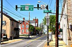
Corner of Main and Water in downtown Thurmont. | |
| Motto: "...Gateway to the Mountains"[1] | |
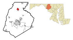 Location of Thurmont, Maryland | |
| Coordinates: 39°37′30″N 77°24′37″W / 39.62500°N 77.41028°WCoordinates: 39°37′30″N 77°24′37″W / 39.62500°N 77.41028°W | |
| Country |
|
| State |
|
| County |
|
| Founded | 1751 |
| Government | |
| • Mayor | John Kinnaird |
| Area[2] | |
| • Total | 3.13 sq mi (8.11 km2) |
| • Land | 3.12 sq mi (8.08 km2) |
| • Water | 0.01 sq mi (0.03 km2) |
| Elevation | 518 ft (158 m) |
| Population (2010)[3] | |
| • Total | 6,170 |
| • Estimate (2012[4]) | 6,351 |
| • Density | 1,977.6/sq mi (763.6/km2) |
| Time zone | Eastern (EST) (UTC-5) |
| • Summer (DST) | EDT (UTC-4) |
| ZIP code | 21788 |
| Area code(s) | 301 |
| FIPS code | 24-77825 |
| GNIS feature ID | 0587792 |
| Website | Town of Thurmont, Maryland |
Thurmont is a town in Frederick County, Maryland, United States. The population was 6,170 at the 2010 census. The town is located in the northern part of Frederick County (north of Frederick, Maryland, the county seat), approximately ten miles from the Pennsylvania border, along U.S. Highway 15. It is very close to Cunningham Falls State Park and Catoctin Mountain Park, which contains the presidential retreat of Camp David. Thurmont is also home to Catoctin Colorfest, an arts and crafts festival that draws in about 125,000 people each autumn.[5]
In 2005, Thurmont was designated as a "Main Street Maryland Community." [6][7]
History
Originally incorporated as the Town of Mechanicstown in 1751, the name of the town was changed to Thurmont by an act of Maryland General Assembly on January 18, 1894.[8]
The Western Maryland Railway built its main railroad line to Thurmont in 1871, connecting the town with Baltimore, and later with Hagerstown and Cumberland.[9]
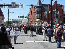
In May 2012, the 38th G8 summit was held at Camp David, a short distance from the town of Thurmont itself. Hundreds of protesters, who were attempting to gain attention for Ethiopia, stopped all traffic on Main Street and Sheriff Deputies were called into service to keep control of the peaceful protest.
Geography

Thurmont is located at 39°37′30″N 77°24′37″W / 39.62500°N 77.41028°W (39.624974, -77.410245).[10]
According to the United States Census Bureau, the town has a total area of 3.13 square miles (8.11 km2), of which, 3.12 square miles (8.08 km2) is land and 0.01 square miles (0.03 km2) is water.[2]
Climate
The climate in this area is characterized by hot, humid summers and generally mild to cool winters. According to the Köppen Climate Classification system, Thurmont has a humid subtropical climate, abbreviated "Cfa" on climate maps.[11]
Demographics
| Historical population | |||
|---|---|---|---|
| Census | Pop. | %± | |
| 1890 | 930 | — | |
| 1900 | 868 | −6.7% | |
| 1910 | 903 | 4.0% | |
| 1920 | 1,074 | 18.9% | |
| 1930 | 1,185 | 10.3% | |
| 1940 | 1,307 | 10.3% | |
| 1950 | 1,676 | 28.2% | |
| 1960 | 1,998 | 19.2% | |
| 1970 | 2,359 | 18.1% | |
| 1980 | 2,934 | 24.4% | |
| 1990 | 3,398 | 15.8% | |
| 2000 | 5,588 | 64.4% | |
| 2010 | 6,170 | 10.4% | |
| Est. 2015 | 6,454 | [12] | 4.6% |
The median income for a household in the town was $49,530, and the median income for a family was $56,138. Males had a median income of $37,804 versus $27,266 for females. The per capita income for the town was $20,474. About 4.0% of families and 6.1% of the population were below the poverty line, including 8.3% of those under age 18 and 5.8% of those age 65 or over.
2010 census
As of the census[3] of 2010, there were 6,170 people, 2,354 households, and 1,701 families residing in the town. The population density was 1,977.6 inhabitants per square mile (763.6/km2). There were 2,498 housing units at an average density of 800.6 per square mile (309.1/km2). The racial makeup of the town was 95.8% White, 1.0% Black, 0.4% Native American, 0.6% Asian, 0.7% from other races, and 1.5% from two or more races. Hispanic or Latino of any race were 2.4% of the population.
There were 2,354 households of which 36.7% had children under the age of 18 living with them, 56.9% were married couples living together, 11.3% had a female householder with no husband present, 4.1% had a male householder with no wife present, and 27.7% were non-families. 22.3% of all households were made up of individuals and 9.3% had someone living alone who was 65 years of age or older. The average household size was 2.62 and the average family size was 3.08.
The median age in the town was 39.5 years. 25.8% of residents were under the age of 18; 7.2% were between the ages of 18 and 24; 26.3% were from 25 to 44; 27.7% were from 45 to 64; and 13.1% were 65 years of age or older. The gender makeup of the town was 48.4% male and 51.6% female.
References
- ↑ "Town of Thurmont, Maryland". Town of Thurmont, Maryland. Retrieved August 24, 2012.
- 1 2 "US Gazetteer files 2010". United States Census Bureau. Retrieved 2013-01-25.
- 1 2 "American FactFinder". United States Census Bureau. Retrieved 2013-01-25.
- ↑ "Population Estimates". United States Census Bureau. Retrieved 2013-06-26.
- ↑ Bondeson, Jen (13 October 2013). "Colorfest celebrates 50 years of crafts and community". The Frederick News Post. Retrieved 14 October 2013.
- ↑ Maryland Department of Housing and Community Development, Baltimore, MD. "Main Street Maryland." Accessed 2010-09-15.
- ↑ Town of Thurmont, MD. "Welcome"
- ↑ "Thurmont, Maryland". Town City-Data.com. Retrieved August 24, 2012.
- ↑ Wireman, George W. (1969). Gateway to the Mountains. Hagerstown, MD: Hagerstown Bookbinding & Print. Co. "Chapter 15: Western Maryland Railway Company."
- ↑ "US Gazetteer files: 2010, 2000, and 1990". United States Census Bureau. 2011-02-12. Retrieved 2011-04-23.
- ↑ Climate Summary for Thurmont, Maryland
- ↑ "Annual Estimates of the Resident Population for Incorporated Places: April 1, 2010 to July 1, 2015". Retrieved July 2, 2016.
- ↑ "Census of Population and Housing". Census.gov. Retrieved June 4, 2015.
External links
- Town of Thurmont
- myThurmont.net Thurmont Community Website
- The News-Journal Thurmont Community Newspaper
- "Thurmont Scrapbook" – History articles from Greater Emmitsburg Area Historical Society
- "ThurmontFirst" The Thurmont Economic Development and Main Street web site featuring the online business directory, business news, events and photo albums.
- "The R. S. Kinnaird Collection of Historic Thurmont Images" A collection of over 4,200 images of Thurmont and surrounding communities.
-
 Geographic data related to Thurmont, Maryland at OpenStreetMap
 |
Sabillasville |
Emmitsburg, Gettysburg, PA |
Taneytown |
|
| Smithsburg |
|
Rocky Ridge | ||
| ||||
| | ||||
| Wolfsville Catoctin Hollow Road |
Lewistown, Frederick |
Creagerstown |
Municipalities and communities of Frederick County, Maryland, United States | ||
|---|---|---|
| Cities | 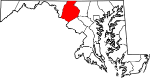 | |
| Towns | ||
| Village | ||
| CDPs | ||
| Other communities |
| |
| Footnotes | ‡This populated place also has portions in an adjacent county or counties | |