Tiscoffin
| Tiscoffin Tigh Scoithín | |
|---|---|
| Civil Parish | |
 Tiscoffin Location in Ireland | |
| Coordinates: 52°39′15″N 7°07′50″W / 52.6542265°N 7.130461°WCoordinates: 52°39′15″N 7°07′50″W / 52.6542265°N 7.130461°W | |
| Country | Ireland |
| Province | Leinster |
| County | County Kilkenny |
Tiscoffin (Irish: Tigh Scoithín, meaning "house of Scoithín") is a civil parish, in County Kilkenny, Ireland.[1][2][3]
It lies in the old barony of Gowran, county of Kilkenny, and province of Leinster, roughly ten kilometres east of Kilkenny town. Tiscoffin is reputedly the site of a battle in 1362, where James Butler, 2nd Earl of Ormond slew around six hundred of the clan of the Mac Murroughs - (Art Mór Mac Murchadha Caomhánach).[4]
Tiscoffin parish is the location of Freestone hill: the site of an Iron Age ringfort and Bronze Age cairn. During archaeological excavations in 1948 and 1949 led by Dr. Gerhard Bersu, a number of important Roman artifacts were unearthed. These included: a decorated bracelet, a possible buckle stud, a strip of decorated bronze and three rings, a copper coin of Constantine the Great (c.337 to 340AD), iron needles, a blue glass bracelet, two shreds of later Roman pottery and a small, polished cone.[5]
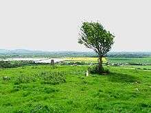
On top of Freestone hill stands an ancient hawthorn tree long held in reverence by the local population.
Freynestown townland was the site of the old monastery of St. Scuithin from whom Tiscoffin-(Tigh Scuithin) drives its placename.
The parish comprises 7128 statute acres; Culm (coal) has been found within its limits, and was formerly worked. It is a rectory, in the Diocese of Ossory (Roman Catholic), constituting the corps of the prebend of Tascoffin in St Canice's Cathedral, Kilkenny, and in the patronage of the Bishop. The church was built 1796 in Ireland. In the R. C. divisions the parish forms part of the union or district of Gowran, and contains a chapel. About 130 children are educated in three private schools. [From A Topographical Dictionary of Ireland (1837)]
Tiscoffin townlands
Consists of the following townlands:
|
|
|
References
- ↑ "Placenames Database of Ireland". logainm.ie. Retrieved 2014-02-22.
- ↑ Patrick Weston Joyce (1871). The Origin and History of Irish Names of Places. McGlashan & Gill. pp. 53–.
- ↑ Joyce, Patrick Weston (1922). Irish Local Names Explained. Dublin: The Educational Company of Ireland. p. 4.
- ↑ Sullivan, A.M. (1900). Atlas and Cyclopedia of Ireland. Libraryireland.com. Retrieved 2014-02-22.
- ↑ http://www.jstor.org/stable/25505153
External links
Places in County Kilkenny | ||
|---|---|---|
| Towns | 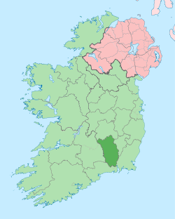 | |
| Villages |
| |
| Townlands | ||
| ||