Tolo Highway
| |
|---|---|
| Part of Route 9 | |
| Route information | |
| Maintained by Highways Department | |
| Length: | 11.3 km (7.0 mi) |
| Existed: | 1987 – present |
| Major junctions | |
| East end: | Sha Tin (near Ma Liu Shui) |
|
8 in total; | |
| West end: | Tai Po (Tai Hang San Wai) |
| Highway system | |
| Hong Kong Strategic Route and Exit Number System | |

Tolo Highway (Chinese: 吐露港公路; pinyin: Tùlùgǎng Gōnglù; Cantonese Yale: tou3 lou6 gong2 gung1 lou6) is a major expressway on Route 9 in Hong Kong. It connects the new towns of Sha Tin and Tai Po in the eastern New Territories, and was constructed in three stages between 1985 and 1987.
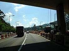
The highway diverges from Tai Po Road near Sha Tin Racecourse. The following 7.3 kilometres (4.5 mi) of the road runs on an embankment on the west coast of Tolo Harbour towards Yuen Chau Tsai (Island House). This section is built alongside the East Rail Line. Construction began in March 1999 to expand the section to a dual four-lane carriageway and was finished in August 2003.[1] This section has a speed limit of 100 km/h.
The next section, 5 km (3.1 mi) long, bypasses Tai Po on the hills to its south. This section remains a dual 3-lane carriageway in its original configuration and the road name changes at Lam Kam Interchange where it connects to the Fanling Highway via a viaduct and interchanges with Lam Kam Road, Tai Po Road and Tai Wo West Service Road. This section is currently being upgraded to a dual four-lane carriageway. Construction began in August 2009 and was completed in March 2014.[2] This section has a speed limit of 80 km/h.
Interchanges and junctions
There are 6 junctions along Tolo Highway: Sha Tin Racecourse, Ma Liu Shui, Science Park, Island House, Tat Wan Road and Tai Po Tai Wo Road.
| District | Location | km[3][4] | Interchange name | Exit | Destinations[5] | Notes |
|---|---|---|---|---|---|---|
| Sha Tin | Fo Tan | 8.9 | Southern terminus; | |||
| 8.9 | 3 | Sha Tin Racecourse | Northbound exit and southbound entrance from and to | |||
| Ma Liu Shui | 10.1 | 3A | Southbound exit and northbound entrance only | |||
| 10.1 | 4 | Chak Cheung Street / Science Park Road – Ma Liu Shui, Ma On Shan; Pak Shek Kok | Southbound entrance from Sui Cheung Road | |||
| Tai Po | Pak Shek Kok | 13.4 | 4A | Chong San Road – Pak Shek Kok, Science Park | No northbound exit | |
| Tai Po | 16.0 | Island House | 5 | Tai Po Road — Yuen Chau Tsai / Yuen Shin Road / Tai Po Tai Wo Road – Tai Po South, Tai Po Industrial Estate, Tai Po Market | ||
| 17.0 | 5A | Tat Wan Road – Tai Po South | Northbound exit and southbound entrance only | |||
| Tai Wo | 19.5 | 6 | Tai Po Tai Wo Road – Tai Po North, Tai Wo | |||
| Tai Hang | 20.2 | Northern terminus; | ||||
1.000 mi = 1.609 km; 1.000 km = 0.621 mi
| ||||||
See also
References
- ↑ "Widening of Tolo Highway between Island House Interchange and Ma Liu Shui Interchange". Highways Department of the Hong Kong Government. Retrieved 2 August 2012. External link in
|publisher=(help) - ↑ "Widening of Tolo Highway/Fanling Highway between Island House Interchange and Tai Hang". Highways Department of the Hong Kong Government. Retrieved 30 September 2014. External link in
|publisher=(help) - ↑ "Open Source Routing Machine". Retrieved 29 March 2014.
- ↑ "Google Maps Street View". Google. Retrieved 10 January 2014.
- ↑ "Route Diagram - Route 9". Transport Department of the Government of Hong Kong. Retrieved 10 January 2014.
External links
| Wikimedia Commons has media related to Tolo Highway. |
| Preceded by Tai Po Road — Sha Tin |
Hong Kong Route 9 Tolo Highway |
Succeeded by Fanling Highway |