Tregirls
Coordinates: 50°33′00″N 4°56′59″W / 50.55001°N 4.94968°W
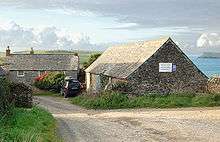
Tregirls (Cornish: Tregryllas, meaning farmstead of the ruins of an ancient dwelling) is a farmstead in Cornwall, United Kingdom. It is situated approximately half-a-mile (1 km) north of Padstow.[1] The settlement consists of a farm and converted cottages which are let as holiday accommodation.[2]
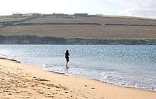
Tregirls beach (which takes its name from the settlement) is 500 metres north at grid reference SW 911 769. The north-facing beach is in the River Camel estuary and is backed by dunes. The South West Coast Path runs behind the beach.[3]
At low water, Tregirls beach extends half-a-mile into the estuary and at its northeast point forms the Doom Bar, a spit of sand across the river mouth.[4]
The settlement takes its name from the manor of Grylls or Tregrylls of which it was a parcel along with Crugmeer, Treator, and Trenio.[5]
References
- ↑ Ordnance Survey: Landranger map sheet 200 Newquay & Bodmin ISBN 978-0-319-22938-5
- ↑ Tregirls Farm website. Retrieved April 2010
- ↑ Ordnance Survey: Explorer map sheet 106, ISBN 978-0-319-24016-8
- ↑ Ordnance Survey: Explorer map sheet 106, ISBN 978-0-319-24016-8
- ↑ "An Index to the Historical Place Names of Cornwall". Retrieved 21 February 2013.
Cornwall Portal | |
| Unitary authorities | |
| Major settlements |
|
| Rivers | |
| Topics | |