Trenton, Georgia
| Trenton, Georgia | ||
|---|---|---|
| City | ||
| City of Trenton | ||
|
Dade County Courthouse, Trenton, 2009. | ||
| ||
 Location in Dade County and the state of Georgia | ||
 Trenton Location within the contiguous United States of America | ||
| Coordinates: 34°52′32″N 85°30′31″W / 34.87556°N 85.50861°WCoordinates: 34°52′32″N 85°30′31″W / 34.87556°N 85.50861°W | ||
| Country |
| |
| State |
| |
| County | Dade | |
| Founded | 1830s | |
| Incorporated | February 18, 1854 | |
| Named for | Trenton, New Jersey | |
| Government | ||
| • Type | Mayor-Council | |
| Area | ||
| • Total | 3.1 sq mi (8.0 km2) | |
| • Land | 3.1 sq mi (8.0 km2) | |
| • Water | 0.0 sq mi (0 km2) | |
| Elevation | 758 ft (231 m) | |
| Population (2010) | ||
| • Total | 2,301 | |
| • Density | 742.2/sq mi (244.2/km2) | |
| Time zone | EST (UTC-5) | |
| • Summer (DST) | EDT (UTC-4) | |
| ZIP code(s) | 30752 | |
| Area code(s) | 706, 762 | |
| FIPS code | 13-77372[1] | |
| GNIS feature ID | 0333261[2] | |

Trenton is a city in Dade County, Georgia, United States. Founded in the 1830s, the area was originally known as Salem. In 1839 Salem was designated the seat of the newly formed Dade County. It was renamed Trenton in 1841.[3] The population was 2,301 at the 2010 census. It is the only incorporated municipality in the county, and as such it serves as the county seat. Trenton is part of the Chattanooga, Tennessee–GA Metropolitan Statistical Area.
History
This was historically part of Cherokee people territory before Georgia and the United States forced them to cede lands and, under Indian Removal Act, relocate to Indian Territory in the 1830s. The area was developed largely for subsistence farming.
The noted Southern humorist George Washington Harris (1814–1869) is buried in the Brock Cemetery in Trenton. Although he was considered one of the seminal writers of Southern humor and greatly influenced the literary works of Mark Twain, William Faulkner,[4] and Flannery O'Connor,[5] his grave was not officially identified and marked with a monument until 2008.
Geography
Trenton is located at 34°52′32″N 85°30′31″W / 34.87556°N 85.50861°W (34.875609, −85.508644).[6]
According to the United States Census Bureau, the city has a total area of 3.1 square miles (8.0 km2), all of it land.
Demographics
| Historical population | |||
|---|---|---|---|
| Census | Pop. | %± | |
| 1870 | 223 | — | |
| 1880 | 255 | 14.3% | |
| 1890 | 378 | 48.2% | |
| 1900 | 349 | −7.7% | |
| 1910 | 302 | −13.5% | |
| 1920 | 295 | −2.3% | |
| 1930 | 370 | 25.4% | |
| 1940 | 570 | 54.1% | |
| 1950 | 755 | 32.5% | |
| 1960 | 1,301 | 72.3% | |
| 1970 | 1,523 | 17.1% | |
| 1980 | 1,682 | 10.4% | |
| 1990 | 1,994 | 18.5% | |
| 2000 | 1,942 | −2.6% | |
| 2010 | 2,301 | 18.5% | |
| Est. 2015 | 2,238 | [7] | −2.7% |
As of the census[9] of 2010, there were 2,301 people, 904 households, and 599 families residing in the city. The population density was 742.25 people per square mile (244.2/km²). There were 1,012 housing units at an average density of 326.45 per square mile (106.0/km²). The racial makeup of the city was 95.5% White, 0.7% African American, 0.3% Native American, 0.8% Asian, 0.2% Pacific Islander, 0.9% from other races, and 1.7% from two or more races. Hispanic or Latino of any race were 3.2% of the population.
There were 904 households out of which 31.6% had children under the age of 18 living with them, 46.9% were married couples living together, 14.5% had a female householder with no husband present, and 33.7% were non-families. 29.2% of all households were made up of individuals who lived alone, and 12.9% of those were someone living alone who was 65 years of age or older. The average household size was 2.40 and the average family size was 2.94.
In the city the population was spread out with 27.0% under the age of 18, 15.3% from 20 to 29, 12.7.2% from 30 to 39, 31.0% from 40 to 64, and 13.7% who were 65 years of age or older. The median age was 35.9 years. For every 100 females there were 98.36 males. For every 100 females age 18 and over, there were 94.18 males in the same age group.
The median income for a household in the city was $34,612, and the median income for a family was $40,450. Males had a median income of $31,354 versus $22,104 for females. The per capita income for the city was $16,336. About 10.5% of families and 13.4% of the population were below the poverty line, including 17.5% of those under age 18 and 11.4% of those age 65 or over.
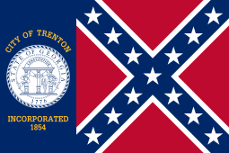
Flag
In 2001, Georgia replaced its state flag, as some citizens had objected that its design incorporated the Confederate battle flag. That year, Trenton city officials adopted the old state flag as a city flag. The city had already used it from 1956 to 2001 as an official city banner. (This followed the 1954 United States Supreme Court ruling in Brown v. Board of Education that racially segregated public education was unconstitutional.) After adopting the former state flag for the city in 2001, the Trenton City Council also voted to post a plaque bearing the Ten Commandments at city hall.[10] The city flies the flag outside the city hall/police department building and in the city park next to the courthouse and library. In addition, many local businesses fly it.
The city also flies one of the historic flags of the Confederate States of America, the Blood-Stained Banner, in the city park.
Education
The Dade County School District administers grades pre-school to grade twelve. It operates two elementary schools, a middle school, and a high school.[11] The district has 167 full-time teachers and over 2,630 students.[12]
- Dade Elementary School
- Davis Elementary School
- Dade Middle School
- Dade County High School
Attractions
- Cloudland Canyon State Park
- Dade County Courthouse is listed on the National Register of Historic Places listings in Georgia (National Register of Historic Places).
Major roads and travel
- Interstate 59: I-59 runs north and south and connects Birmingham to Chattanooga
- U.S. Route 11 runs north and south, parallel to Interstate 59
- State Route 136: Hwy 136 runs west and east and connects Dade County to Walker County.
- Norfolk Southern Railway
Media
- The Dade County Sentinel, newspaper and online
- Discover Dade (Local media portal and news service)
- WKWN AM 1420 (also called K-win)
See also
- List of municipalities in Georgia (U.S. state)
- National Register of Historic Places listings in Dade County, Georgia
References
- ↑ "American FactFinder". United States Census Bureau. Retrieved 2008-01-31.
- ↑ "US Board on Geographic Names". United States Geological Survey. 2007-10-25. Retrieved 2008-01-31.
- ↑ Hellmann, Paul T. (May 13, 2013). Historical Gazetteer of the United States. Routledge. p. 250. Retrieved 30 November 2013.
- ↑ Faulkner, William. "The Art of Fiction no. 12: William Faulkner". The Paris Review. Retrieved 9 December 2012.
- ↑ Donald Day, "The Life of George Washington Harris," Tennessee Historical Quarterly, Vol. 6, No. 1 (March 1947), pp. 3–38.
- ↑ "US Gazetteer files: 2010, 2000, and 1990". United States Census Bureau. 2011-02-12. Retrieved 2011-04-23.
- ↑ "Annual Estimates of the Resident Population for Incorporated Places: April 1, 2010 to July 1, 2015". Retrieved July 2, 2016.
- ↑ "Census of Population and Housing". Census.gov. Retrieved June 4, 2015.
- ↑ "American FactFinder". United States Census Bureau. Retrieved 2011-05-14.
- ↑ Rick Wyatt (2009-07-04). "Trenton, Georgia (U.S.)". Flags of the World. Retrieved 6 July 2010.
- ↑ Georgia Board of Education, Retrieved June 6, 2010.
- ↑ School Stats, Retrieved June 6, 2010.
External links
- Trenton, Georgia at the Chickamauga Campaign Trail
- Trenton, Georgia at Georgia.gov
Municipalities and communities of Dade County, Georgia, United States | ||
|---|---|---|
| City | 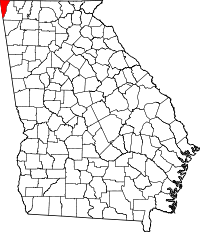 | |
| Unincorporated communities | ||