Tropical Depression Nineteen (1970)
| Tropical depression (SSHWS/NWS) | |
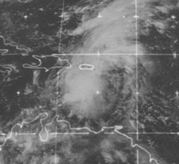 Satellite image of the depression south of Puerto Rico | |
| Formed | September 23, 1970 |
|---|---|
| Dissipated | October 20, 1970 |
| (Extratropical after October 11) | |
| Highest winds |
1-minute sustained: 35 mph (55 km/h) |
| Lowest pressure | 1000 mbar (hPa); 29.53 inHg |
| Fatalities | At least 22 |
| Damage | > $65.5 million (1970 USD) |
| Areas affected | Lesser Antilles (especially Barbados and USVI), Puerto Rico |
| Part of the 1970 Atlantic hurricane season | |
Tropical Depression Nineteen in 1970 was the wettest known tropical cyclone to affect the United States territory of Puerto Rico.[1] The long-lived depression formed on September 24 just off the west coast of Africa, and for several days maintained a general westward track. It passed through the Lesser Antilles on October 1, and later stalled in the eastern Caribbean Sea. On October 8, the depression crossed over the Dominican Republic, and subsequently it accelerated to the northeast. It was declassified as a tropical cyclone on October 12, although its remnants persisted for another week before dissipating in the westerlies near the Azores.
The depression produced heavy rainfall in the Lesser Antilles, reaching 12 in (300 mm) on Barbados; it left three deaths and moderate damage on the island. Another death was reported in the United States Virgin Islands. Torrential rainfall on Puerto Rico inflicted heavy damage, totaling $65 million (1970 USD, $380 million 2016 USD). The highest precipitation total was 41.68 in (1,059 mm) in Jayuya, of which 17 in (430 mm) fell in a 24‑hour period. Most of the damage can be attributed to damaged sugar cane and coffee crops. At least 18 people were killed on the island, and the system was considered one of the worst disasters in Puerto Rican history.
Meteorological history

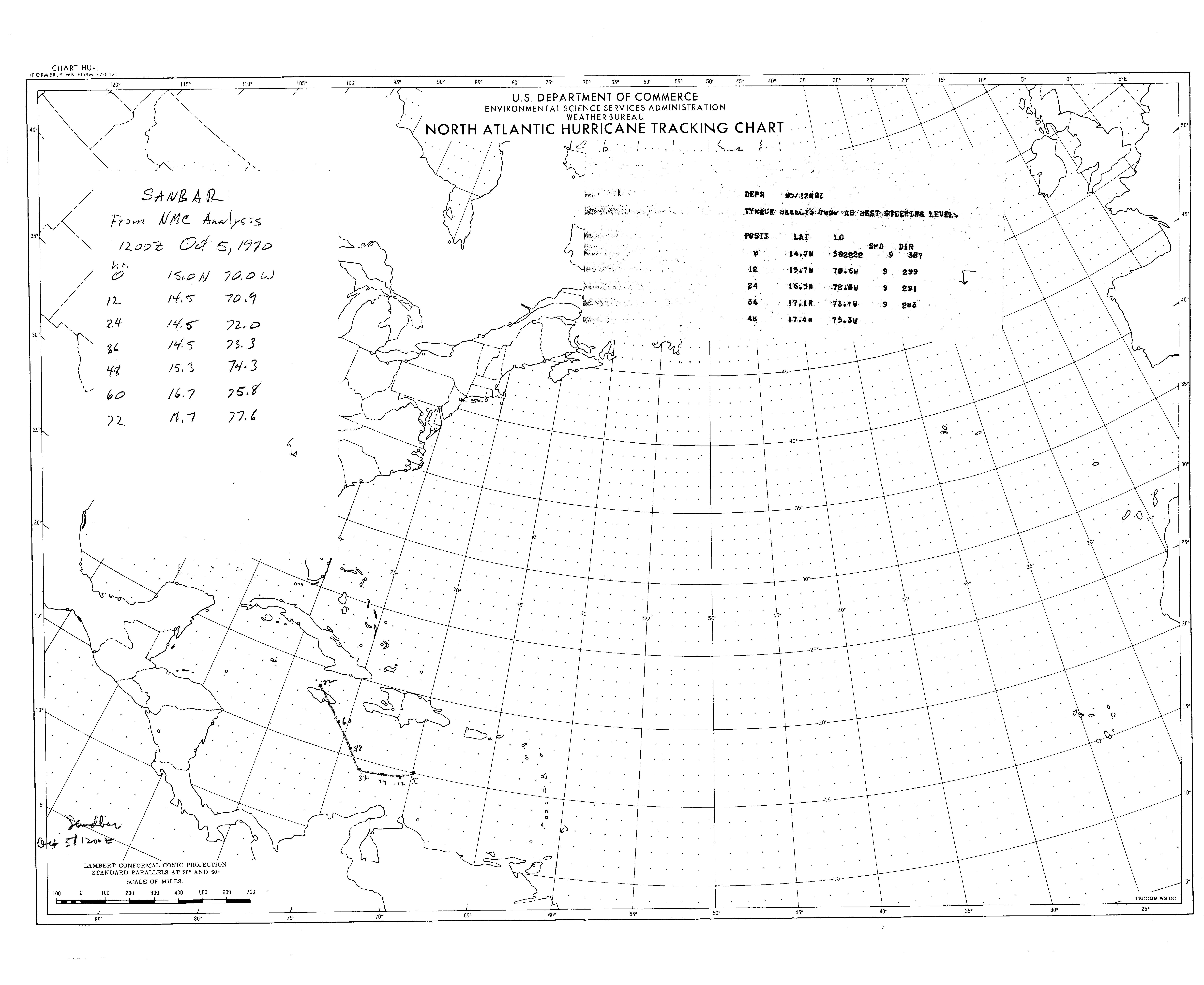
The origins of the depression were identified as a tropical wave on September 22 over western Africa.[2] The system exited the west coast of Africa the next day,[1] and on September 24 it developed into a tropical depression about 95 mi (153 km) southwest of Conakry, Guinea. The depression moved generally westward, gradually intensifying to attain peak winds of 35 mph (56 km/h) by September 25.[3] A nearby upper-level trough — an elongated area of low pressure — hindered further strengthening, and on October 1 the depression struck the island of Saint Lucia. As it crossed the Lesser Antilles, its winds and barometric pressure approached the values of a tropical storm.[2]
In the Caribbean, the trough caused the depression to slow to a westward drift, resulting in several days of heavy rainfall in the region, particularly Puerto Rico.[2] One forecast on October 5 anticipated a continued westward track toward Jamaica.[4] Instead, the depression turned to the north the next day under the influence of the upper-level westerlies.[2] On October 7, the depression attained its lowest pressure of 1000 mbar (29.53 inHg), off the southern coast of Hispaniola.[3] The next day, it made landfall in Peravia Province in the Dominican Republic.[1] After crossing the country and exiting into the Atlantic Ocean, the depression accelerated to the northeast, followed by an eastward turn on October 10 before another turn to the northeast.[2] By October 12, the depression could no longer be classified as a tropical cyclone,[3] although satellite imagery indicated that its remnants continued northeastward. On October 15 the system turned to the west, suppressed by a strong high-pressure area to its north. It re-intensified while crossing through the Azores, attaining a pressure of 994 mbar. It turned to the northwest and was absorbed into the westerlies on October 20.[2]
Preparations, impact, and aftermath
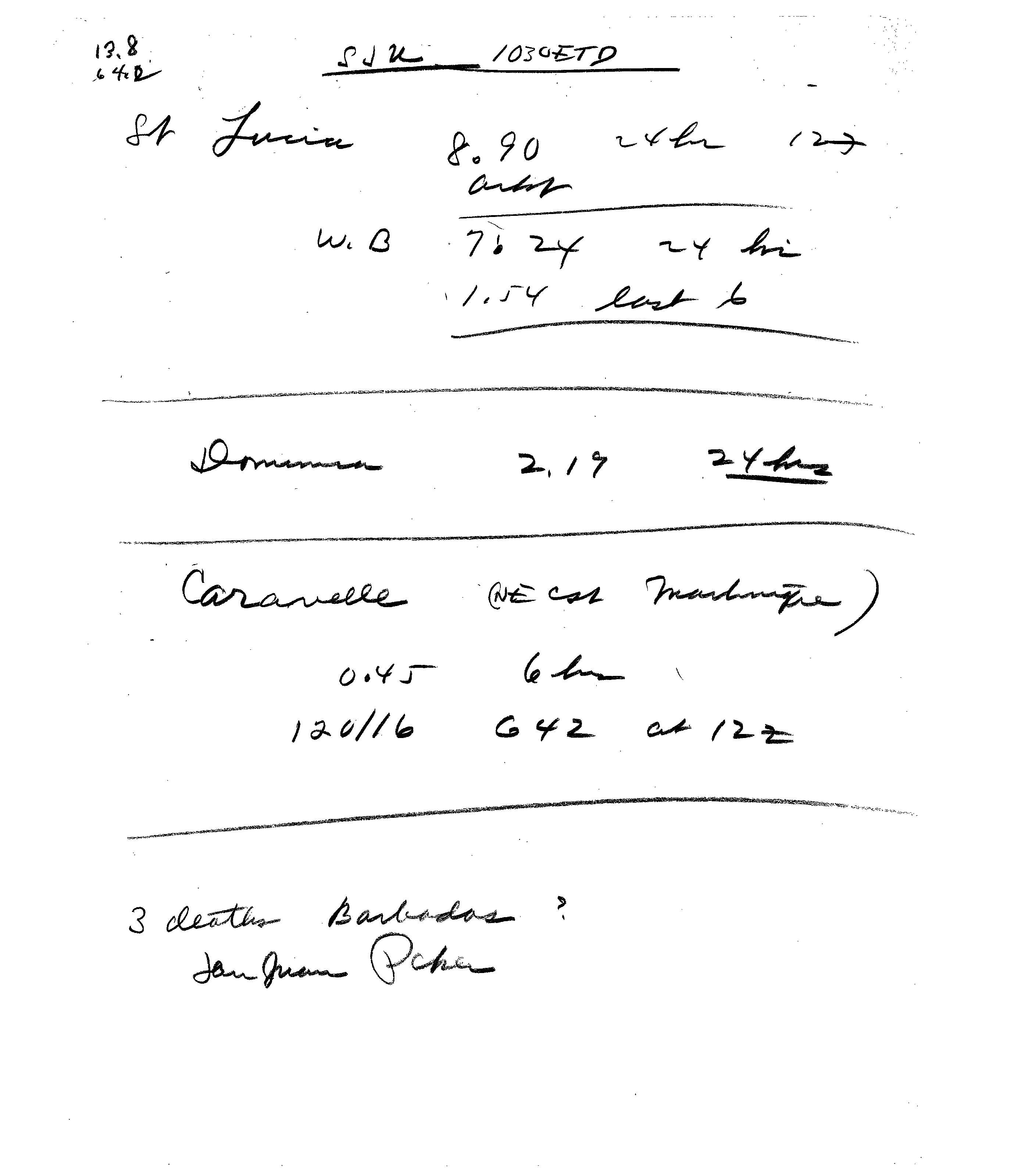
Around October 3, forecasters advised residents on islands from Barbados and St. Vincent through Guadeloupe to prepare for floods, high seas, and gale-force gusts.[5] On October 10, a warning to be on guard against gusts was issued to owners of light aircraft in Puerto Rico and the Virgin Islands.[6] As it crossed through the islands, the depression produced heavy rainfall, including 8.90 in (226 mm) on Saint Lucia, 2.19 in (56 mm) on Dominica,[7] and 12 in (300 mm) on Barbados.[8] In the latter island, the depression left 200 people homeless, caused $500,000 in damage, and killed three people.[9]
Heavy rains impacted the U.S. Virgin Islands, including a total of 11.4 in (290 mm) recorded by the National Park Service on Saint John. The rains caused flooding across the territory, washing out roads and destroying several houses. One boy was swept away by the floodwaters, although he was rescued by two people. A girl was also swept by the floods and drowned.[10] The desalination plant on Saint Croix was damaged during the floods, temporarily stopping the supply of drinking water; water from Puerto Rico had to be shipped to provide the 700,000 gallons needed daily.[11] On St. Thomas, the main airport was closed for several days.[12]
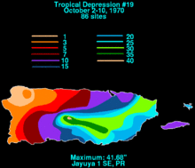
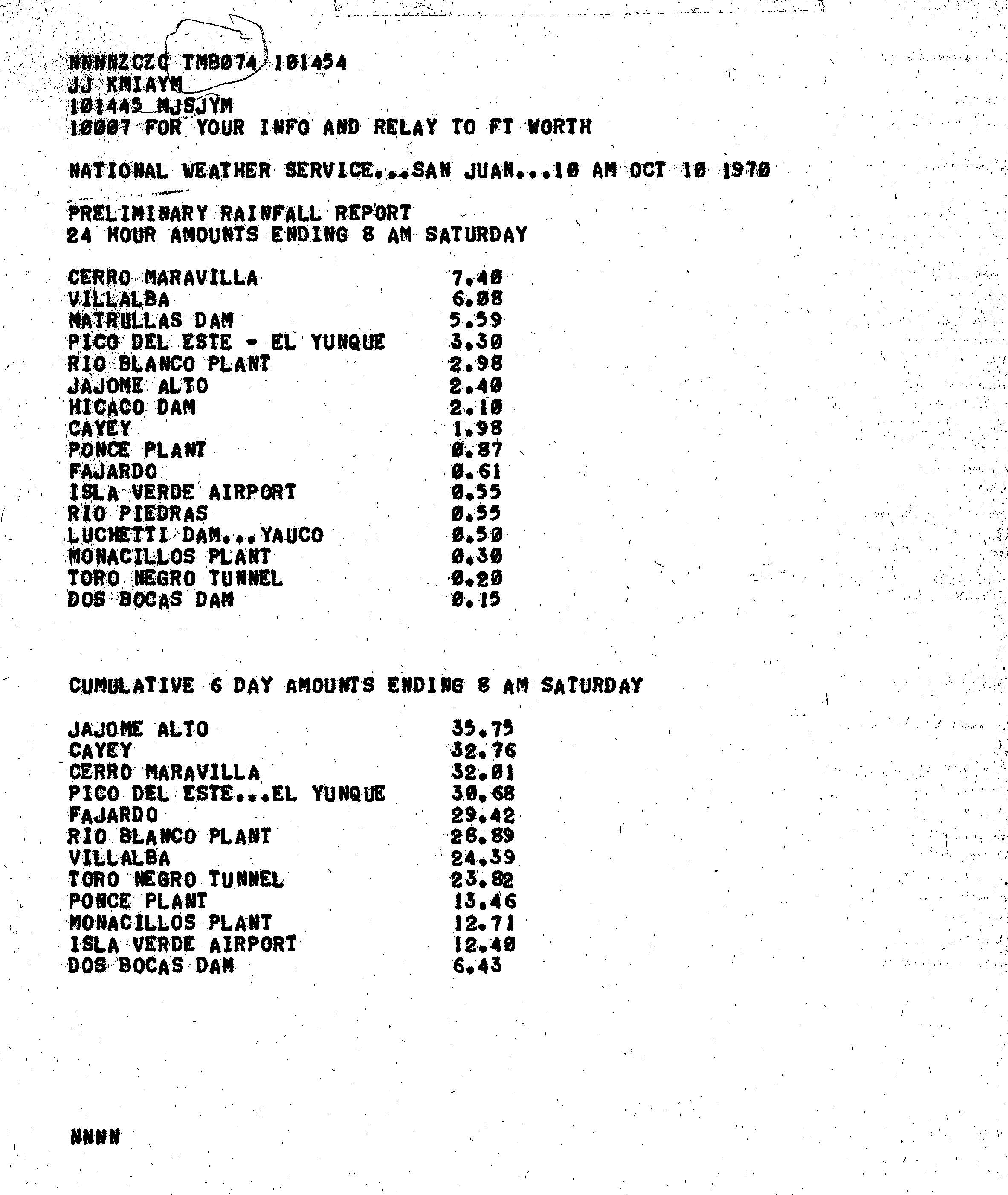
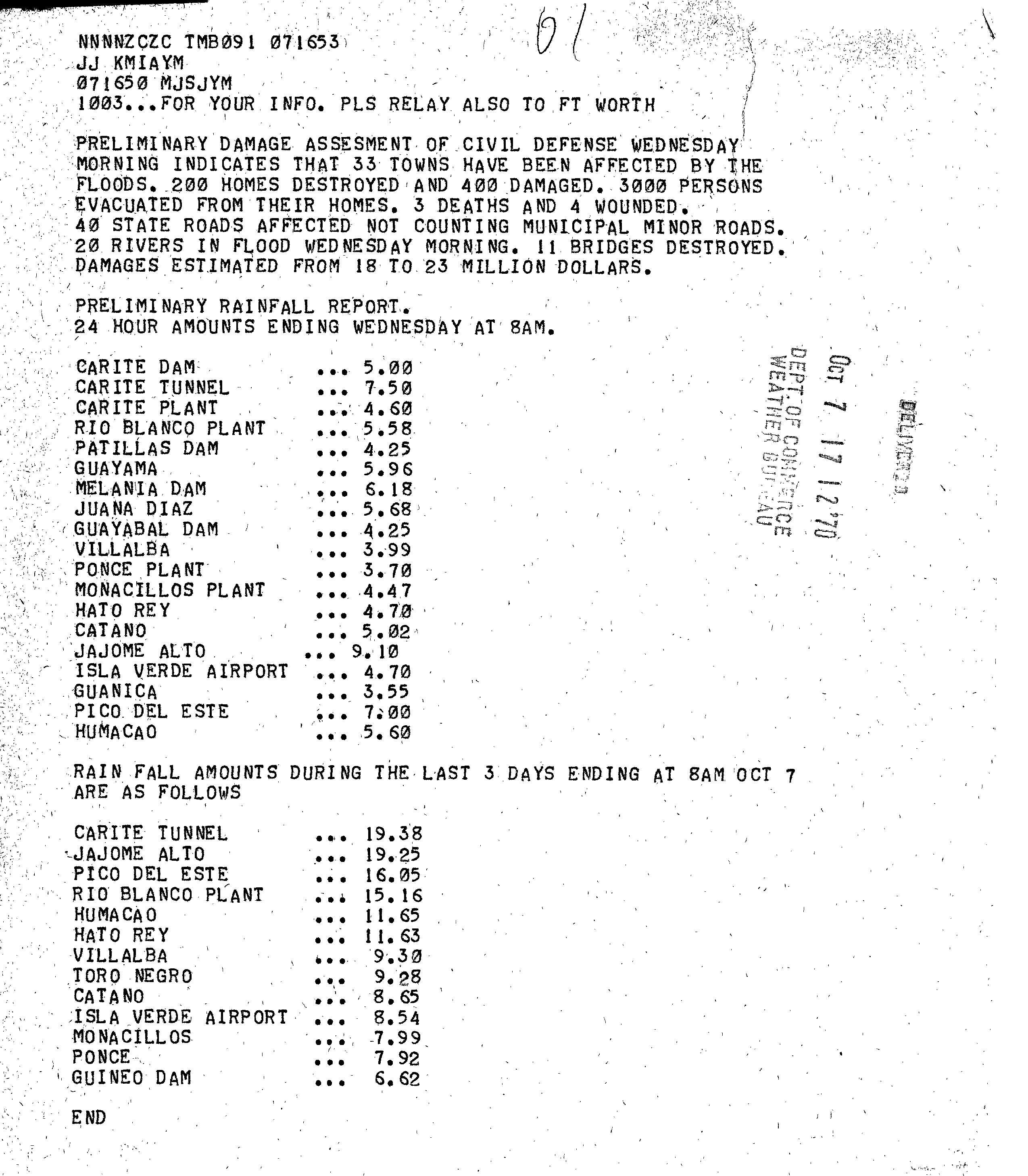
For six days, the depression dropped rainfall across the northern Caribbean, particularly in Puerto Rico.[2] The highest overall rainfall total was 41.68 in (1,059 mm), recorded at a station near Jayuya in the center of the island.[1] This was the highest rainfall total from a tropical cyclone on record in Puerto Rico, surpassing that of the deadly hurricanes of 1928 and 1899,[1][2] which produced 29.6 in (750 mm) and 23.0 in (580 mm), respectively.[13] The station at Jayuya also recorded 17 in (430 mm) in 24 hours.[2] Four other locations reported over 30 in (760 mm).[14] Such heavy rainfall caused 20 rivers to swell above flood stages.[15]
The depression left 10,000 people homeless across Puerto Rico,[16] with 3,000 housed in emergency shelters in San Juan.[6] At least 600 houses were destroyed and another 1,000 damaged.[17] Damage was particularly severe in Barceloneta, Aibonito, and Coamo.[16] Across the island, the depression affected at least 40 state roads,[15] with fifteen blocked by landslides, and eleven bridges destroyed.[18] Flooding forced the closure of Puerto Rico Highway 2 between Manatí and Barceloneta.[6] The depression left more than $40 million (1970 USD, $234 million 2016 USD) in crop damage, primarily to sugarcane and coffee, as reported by William R. Poage, the chair of the House Agricultural Committee.[16] Throughout Puerto Rico, the depression caused damage estimated at $65 million (1970 USD, $380 million 2016 USD),[2] as well as at least 18 confirmed fatalities. A reported six months after the depression indicated there were 34 people missing, although their status is unknown.[2]
In the aftermath of the disaster, Luis A. Ferré, the Governor of Puerto Rico, declared a state of emergency over the whole island,[19] asking for $10 million (1970 USD) in federal aid.[16] On October 12, two days after the rains subsided, President Richard Nixon declared the territory as a disaster area.[20] Ferre also appeared in a telethon to raise funds for the homeless. The National Guard, the Red Cross, and other volunteer groups helped the displaced persons.[16] In all, the disaster was described as one of the worst in Puerto Rico history.[18] The Governor of the Virgin Islands, Melvin Evans, requested aid similar to Puerto Rico,[17] and that territory was also declared a federal disaster area about a week after the rains ended.[21] The heavy rainfall in the Virgin Islands caused a marked dinoflagellate algal bloom in the days after the rains ended.[22]
See also
References
- 1 2 3 4 5 Roth, David M. (2008-09-24). "Tropical Depression #19 - October 2–10, 1970". Hydrometeorological Prediction Center. Retrieved 2011-01-06.
- 1 2 3 4 5 6 7 8 9 10 11 Frank, Neil L. (April 1971). "Atlantic Tropical Systems of 1970" (PDF). Monthly Weather Review. American Meteorological Society. 99 (4): 269–277. Bibcode:1971MWRv...99..269S. doi:10.1175/1520-0493(1971)099<0269:AHSO>2.3.CO;2. Retrieved 2011-01-06.
- 1 2 3 Roth, David M. (2009). "Hurricane Data for all Atlantic hurricanes". National Oceanic and Atmospheric Administration. Retrieved 2011-01-06.
- ↑ National Hurricane Center (1970-10-05). "SANBAR Forecast Track" (JPG). National Oceanic and Atmospheric Administration. Retrieved 2011-01-06.
- ↑ "Depression Hits Windwards". Daytona Beach Morning Journal. Associated Press. 1970-10-03. Retrieved 2011-01-06.
- 1 2 3 Associated Press (1970-10-09). "13 Dead In Floods Around Caribbean". Virgin Islands Daily News. Retrieved 2011-01-06.
- ↑ "Impact from the Tropical Depression" (JPG). National Hurricane Center. 1970-10-30. Retrieved 2011-01-06.
- ↑ "Heavy Floods Hit Puerto Rico". Associated Press. 1970-01-06. Retrieved 2011-01-06.
- ↑ Office of U.S. Foreign Disaster Assistance (August 1993). "Significant Data on Major Disasters Worldwide 1990-present" (PDF). Retrieved 2011-01-06.
- ↑ "Island Cleaning Up After Heavy Deluge". The Virgin Islands Daily News. 1970-10-09. Retrieved 2011-01-12.
- ↑ "Evans Says Islands Major Disaster Area". The Virgin Islands Daily News. 1970-10-10. Retrieved 2011-01-12.
- ↑ "Caribbean Flood Deaths Mount". Spartanburg Herald-Journal. Associated Press. 1070-10-09. Retrieved 2011-01-06. Check date values in:
|date=(help) - ↑ Orlando Férez (1970). "Notes on the Tropical Cyclones of Puerto Rico" (PDF). San Juan, Puerto Rico National Weather Service. Retrieved 2011-01-09.
- ↑ Puerto Rico National Weather Service (1970-10-07). "Preliminary Rainfall Report" (JPG). Retrieved 2011-01-06.
- 1 2 "Preliminary Damage Assessment" (JPG). National Hurricane Center. 1970-10-07. Retrieved 2011-01-06.
- 1 2 3 4 5 "Puerto Rico Starts Flood Cleanup Job". Spokesman Review. Associated Press. 1970-10-12. Retrieved 2011-01-06.
- 1 2 "Puerto Rico Reeling From 4 Day Floods". Virgin Islands Daily News. Associated Press. 1970-10-10. Retrieved 2011-01-06.
- 1 2 "Floods Kill 10 In Barbados, Puerto Rico". Morning Record. Associated Press. 1970-10-08. Retrieved 2011-01-06.
- ↑ "Puerto Rico Asks U.S. Flood Relief". Palm Beach Post. United Press International. 1970-10-09. Retrieved 2011-01-06.
- ↑ "Puerto Rico Heavy Rains, Flooding". Federal Emergency Management Agency. 2005-05-20. Retrieved 2011-01-06.
- ↑ "US Virgin Islands Heavy Rains, Flooding". Federal Emergency Management Agency. 2005-05-20. Retrieved 2011-01-12.
- ↑ Paul R. Burkholder; Robert W. Brody and Arthur E. Dammann (June 1972). "Some Phytoplankton Blooms in the Virgin Islands" (PDF). Caribbean Journal of Science. 1: 25–26. Retrieved 2011-01-12.
Tropical cyclones of the 1970 Atlantic hurricane season | |||||||||||||||||||||||||||||||||||||||||||||||||||||
|---|---|---|---|---|---|---|---|---|---|---|---|---|---|---|---|---|---|---|---|---|---|---|---|---|---|---|---|---|---|---|---|---|---|---|---|---|---|---|---|---|---|---|---|---|---|---|---|---|---|---|---|---|---|
 |
| ||||||||||||||||||||||||||||||||||||||||||||||||||||
| |||||||||||||||||||||||||||||||||||||||||||||||||||||