Trotton with Chithurst
| Trotton with Chithurst | |
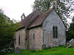 St. Mary at Chithurst |
|
 Trotton with Chithurst |
|
| Area | 7.68 km2 (2.97 sq mi) [1] |
|---|---|
| Population | 329. 2011 Census[2] |
| – density | 43/km2 (110/sq mi) |
| OS grid reference | SU836225 |
| – London | 46 miles (74 km) NE |
| Civil parish | Trotton with Chithurst |
| District | Chichester |
| Shire county | West Sussex |
| Region | South East |
| Country | England |
| Sovereign state | United Kingdom |
| Post town | PETERSFIELD |
| Postcode district | GU31 5 |
| Dialling code | 01730 |
| Police | Sussex |
| Fire | West Sussex |
| Ambulance | South East Coast |
| EU Parliament | South East England |
| UK Parliament | Chichester |
| Website | http://www.trotton-with-chithurst.org.uk/ |
|
|
Coordinates: 50°59′45″N 0°48′35″W / 50.995893°N 0.809682°W
Trotton with Chithurst is a civil parish in the Chichester district of West Sussex, England. Trotton is on the A272 road ten kilometres (7 miles) west of Midhurst. Chithurst is about one mile (2 km) north west of Trotton. The parish also contains the hamlet of Dumpford.
In the 2001 census the parish covered 7.7 square kilometres (3.0 sq mi) and had 129 households with a total population of 328. 160 residents were economically active.[1] At the 2011 Census the population had only increased marginally to 329.[2]
Trotton
The village of Trotton is home to St. George's Church, an Anglican church dating to around 1230.[3] The church is used by the British Orthodox Church once a month. The River Rother crosses the A272 at a bridge near the church.
The author Thomas Otway was born in Trotton in 1652.
Chithurst
The village of Chithurst contains St. Mary's Church and Cittaviveka, the Chithurst Buddhist Monastery, which is a Buddhist monastery located in Chithurst, which was founded by Ajahn Chah and Ajahn Sumedho.
The church dates to the 11th century[4] It is one of the smallest recorded in Taylor & Taylor's Anglo-Saxon Architecture and exhibits Saxon features in the proportions, the thinness of the walls, a splayed window in the south chancel wall, long-and-short work quoins with large shaped stones, and some herringbone work in the stone rubble masonry of the walls. It consists of nave and chancel which show these signs of construction in the Anglo-Saxon era, later west porch and bell turret.
Dumpford

Dumpford is a hamlet located on a minor road between Trotton and Elsted railway station, and also the name of an historic Hundred.[5] It contains one hotel, a sewage works and Terwick watermill.[6]
References
- 1 2 "2001 Census: West Sussex – Population by Parish" (PDF). West Sussex County Council. Retrieved 24 May 2009.
- 1 2 "Civil Parish population 2011". Neighbourhood Statistics. Office for National Statistics. Retrieved 15 October 2015.
- ↑ Chatterton-Newman, Roger (1991). Betwixt Petersfield and Midhurst. Midhurst: Middleton Press. ISBN 0-906520-94-0.
- ↑ Salzman, L. F. (ed) (1953). "A History of the County of Sussex: Volume 4: The Rape of Chichester. Chithurst". Victoria County History of Sussex. British History Online. pp. 4–6. Retrieved 21 January 2012.
- ↑ Details
- ↑ Simon Potter. "Sussex Watermills : Watermills in Sussex : Watermills of Sussex : Sussex Group". sussexmillsgroup.org.uk.