Typhoon Yunya (1991)
| Typhoon (JMA scale) | |
|---|---|
| Category 3 (Saffir–Simpson scale) | |
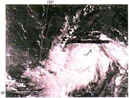 Typhoon Yunya on June 13 near the Philippines | |
| Formed | June 11, 1991 |
| Dissipated | June 17, 1991 |
| Highest winds |
10-minute sustained: 150 km/h (90 mph) 1-minute sustained: 195 km/h (120 mph) |
| Lowest pressure | 950 hPa (mbar); 28.05 inHg |
| Fatalities | 4–7 direct, ~300 indirect |
| Areas affected | Philippines, Taiwan |
| Part of the 1991 Pacific typhoon season | |
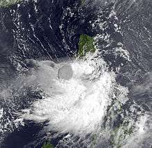
Typhoon Yunya, known in the Philippines as Typhoon Diding, was a strong tropical cyclone that weakened before impacting the Philippines at the time of the colossal eruption of Mount Pinatubo in June 1991. A small tropical cyclone, Yunya rapidly developed from a tropical disturbance near East Samar on June 11. By June 13 the storm had reached typhoon status as it moved west-northwest near the Philippines. Yunya attained its peak intensity the following day with estimated winds of 195 km/h (120 mph);[nb 1] however, strong wind shear soon impacted the typhoon and caused it to rapidly decay. The storm struck southern Luzon early on June 15 as a minimal typhoon before moving over the South China Sea later that day. After turning north and weakening to a tropical depression, the system brushed the southern tip of Taiwan on June 16 before dissipating the following day.
Across the Philippines, Yunya produced heavy rains that triggered significant flooding. Hundreds of homes and several bridges were washed away by swollen rivers. Four people were killed as a direct result of the storm and three others were listed as missing. Although the storm itself caused significant damage, the worst effects were related to the system's heavy rains mixing with volcanic ash from Pinatubo. The combined effects of both natural disasters created numerous large lahars that killed 250–300 people.
Meteorological history
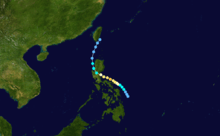
On June 11, 1991, a tropical disturbance developed east of East Samar, Philippines. Situated to the southwest of a Tropical Upper Tropospheric Trough, the system experienced little wind shear and gradually intensified as it moved northwestward.[1] The following day, the Japan Meteorological Agency (JMA) began monitoring the system as a tropical depression.[2][nb 2] At 1500 UTC on June 12, the Joint Typhoon Warning Center (JTWC) issued a Tropical Cyclone Formation Alert on the depression.[nb 3] Around this time, the storm began a period rapid development and a tiny central dense overcast formed. At 1815 UTC, the USNS Spica sailed directly through the storm, measuring a barometric pressure of 989.5 mbar (hPa; 29.22 inHg) and peak winds of 110 km/h (70 mph). Although already a tropical storm, the JTWC did not issue their first advisory on the system until early on June 13, at which time they assigned it the name Yunya.[1]
Based on the measurements provided by the USNS Spica, the storm was analyzed as a midget cyclone with a gale diameter of 150 km (90 mi). Throughout June 13, subsidence around the periphery of Yunya allowed the system to develop good outflow. As a result, the storm attained typhoon status later that day before strengthening slowed. By June 14, Yunya turned towards the west-northwest in response to a subtropical ridge to the north. Following this turn, the typhoon attained its peak intensity as a Category 3 equivalent typhoon on the Saffir–Simpson Hurricane Scale with winds estimated at 195 ;km/h (120 mph).[1] Around the same time, the JMA assessed Yunya to have been slightly weaker, with peak ten-minute winds estimated at 150 km/h (90 mph) along with a pressure of 950 mbar (hPa; 28.05 inHg).[2]
Within hours of reaching its peak strength on June 14, strong wind shear associated with a second subtropical ridge over Asia impacted the typhoon. Due to the system's small size, the shear was able to disrupt the cyclone's core and cause rapid weakening as it approached southern Luzon. Around 0000 UTC on June 15, Yunya made landfall just north of Dingalan Bay as a minimal typhoon and weakened to a tropical storm shortly thereafter. As the storm moved across Luzon, the colossal eruption of Mount Pinatubo took place. Due to Yunya's circulation, the massive cloud of ash produced by the eruption was moistened and redistributed over the Philippines instead of blowing out to sea, greatly exacerbating the impact of the event.[1]
Later on June 15 Yunya emerged into the South China Sea as a minimal tropical storm. Persistent wind shear prevented the system from strengthening and the storm ultimately degraded into a tropical depression by June 16. Having turned north within a break in the subtropical ridge, Yunya brushed the southern tip of Taiwan late on June 16 before dissipating the following day within the westerlies.[1]
Preparations and impact
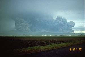
On June 14, officials in the Philippines raised storm warnings in advance of Typhoon Yunya for much of Luzon and areas south of Manila. With Mount Pinatubo having already erupted once by this time, there were fears that the storm's heavy rains, combined with ash from the volcano, would create massive mudflows capable of burying towns 40 km (25 mi) away from Pinatubo. Landslides on June 14 destroyed bridges Santa Fe and homes in Castillejos were washed away.[5] By June 15, air-borne ash combined with the typhoon's rainfall, resulting in widespread travel disruptions and structural collapses. The mixture also made it appear as through it was nighttime during the middle of the day, prompting concern from residents. One person was killed in Olongapo City after the roof of a bus terminal collapsed under the weight of ash and rain. Two others died in an accident near Clark Air Base and another was killed by debris in Manila.[6]
Widespread flooding took place in Luzon as rivers overtopped their banks. Along the Sacobia river in Pampanga Province, at least 170 homes were washed away. The Abacan bridge spanning the Abacan River collapsed with a truck, carrying three people, and an empty car. It is unknown whether or not the three people survived. Civil defense officials confirmed that five other bridges collapsed in Pampanga and Zambales provinces.[6]
See also
- 1991 Pacific typhoon season
- Typhoon Mike (Ruping, 1990)
- Tropical Storm Thelma (Uring, 1991), one of the deadliest tropical cyclones to hit the Philippines in recent recorded history
- Typhoon Angela (Rosing, 1995)
- Typhoon Durian (Reming, 2006)
- Tropical Storm Fung-wong (Mario, 2014)
Notes
- ↑ All winds are in one-minute sustained standards unless otherwise stated.
- ↑ The Japan Meteorological Agency is the official Regional Specialized Meteorological Center for the western Pacific Ocean.[3]
- ↑ The Joint Typhoon Warning Center is a joint United States Navy – United States Air Force task force that issues tropical cyclone warnings for the western Pacific Ocean and other regions.[4]
References
- 1 2 3 4 5 "1991 Annual Tropical Cyclone Report: Typhoon Yunya (05W)" (PDF). Joint Typhoon Warning Center (Report). United States Navy. 1992. pp. 48–53. Retrieved May 18, 2012.
- 1 2 "RSMC Best Track Data - 1990-1999" (.TXT). Japan Meteorological Agency. January 4, 1992. Retrieved May 18, 2012.
- ↑ "Annual Report on Activities of the RSMC Tokyo - Typhoon Center 2000" (PDF). Japan Meteorological Agency. February 2001. p. 3. Retrieved May 18, 2012.
- ↑ "Joint Typhoon Warning Center Mission Statement". Joint Typhoon Warning Center. United States Navy. 2011. Archived from the original on July 26, 2007. Retrieved May 18, 2012.
- ↑ Robert H. Reid (June 14, 1991). "New Eruptions Send Glowing Rivers of Debris Down Volcano". Manila, Philippines: Associated Press. (accessed through LexisNexis)
- 1 2 Martin Abbugao (June 15, 1991). "Typhoon hits Philippines, kills four". Manila, Philippines: United Press International. (accessed through LexisNexis)