Vanderbilt, Michigan
| Vanderbilt, Michigan | |
|---|---|
| Village | |
 Location of Vanderbilt, Michigan | |
| Coordinates: 45°8′35″N 84°39′40″W / 45.14306°N 84.66111°W | |
| Country | United States |
| State | Michigan |
| County | Otsego |
| Area[1] | |
| • Total | 1.13 sq mi (2.93 km2) |
| • Land | 1.13 sq mi (2.93 km2) |
| • Water | 0 sq mi (0 km2) |
| Elevation | 1,096 ft (334 m) |
| Population (2010)[2] | |
| • Total | 562 |
| • Estimate (2012[3]) | 558 |
| • Density | 497.3/sq mi (192.0/km2) |
| Time zone | Eastern (EST) (UTC-5) |
| • Summer (DST) | EDT (UTC-4) |
| ZIP code | 49795 |
| Area code(s) | 989 |
| FIPS code | 26-81700[4] |
| GNIS feature ID | 1615504[5] |
Vanderbilt is a village in Otsego County in the U.S. state of Michigan. The population was 562 at the 2010 census.
Geography
According to the United States Census Bureau, the village has a total area of 1.13 square miles (2.93 km2), all of it land.[1]
Demographics
| Historical population | |||
|---|---|---|---|
| Census | Pop. | %± | |
| 1890 | 370 | — | |
| 1910 | 523 | — | |
| 1920 | 394 | −24.7% | |
| 1930 | 456 | 15.7% | |
| 1940 | 405 | −11.2% | |
| 1950 | 410 | 1.2% | |
| 1960 | 509 | 24.1% | |
| 1970 | 522 | 2.6% | |
| 1980 | 525 | 0.6% | |
| 1990 | 605 | 15.2% | |
| 2000 | 587 | −3.0% | |
| 2010 | 562 | −4.3% | |
| Est. 2015 | 564 | [6] | 0.4% |
2010 census
As of the census[2] of 2010, there were 562 people, 237 households, and 145 families residing in the village. The population density was 497.3 inhabitants per square mile (192.0/km2). There were 278 housing units at an average density of 246.0 per square mile (95.0/km2). The racial makeup of the village was 95.6% White, 0.7% African American, 0.9% Native American, and 2.8% from two or more races. Hispanic or Latino of any race were 0.9% of the population.
There were 237 households of which 26.6% had children under the age of 18 living with them, 45.6% were married couples living together, 13.1% had a female householder with no husband present, 2.5% had a male householder with no wife present, and 38.8% were non-families. 33.3% of all households were made up of individuals and 14.4% had someone living alone who was 65 years of age or older. The average household size was 2.37 and the average family size was 3.01.
The median age in the village was 44 years. 21.7% of residents were under the age of 18; 7.9% were between the ages of 18 and 24; 21.9% were from 25 to 44; 30.3% were from 45 to 64; and 18.1% were 65 years of age or older. The gender makeup of the village was 48.8% male and 51.2% female.
2000 census
As of the census[4] of 2000, there were 587 people, 241 households, and 148 families residing in the village. The population density was 530.6 per square mile (204.2/km²). There were 269 housing units at an average density of 243.2 per square mile (93.6/km²). The racial makeup of the village was 97.79% White, 0.17% African American, 1.70% Native American, and 0.34% from two or more races.
There were 241 households out of which 29.0% had children under the age of 18 living with them, 46.5% were married couples living together, 10.0% had a female householder with no husband present, and 38.2% were non-families. 33.6% of all households were made up of individuals and 14.9% had someone living alone who was 65 years of age or older. The average household size was 2.44 and the average family size was 3.09.
In the village the population was spread out with 25.7% under the age of 18, 10.6% from 18 to 24, 28.8% from 25 to 44, 20.1% from 45 to 64, and 14.8% who were 65 years of age or older. The median age was 36 years. For every 100 females there were 98.3 males. For every 100 females age 18 and over, there were 96.4 males.
The median income for a household in the village was $27,969, and the median income for a family was $37,857. Males had a median income of $25,000 versus $19,875 for females. The per capita income for the village was $11,973. None of the families and 6.8% of the population were living below the poverty line, including no under eighteens and 8.9% of those over 64.
History
The Vanderbilt family owned some land in Corwith Township that was settled about 1875. When the Michigan Central Railroad (also owned by the Vanderbilts) came through in 1880, the village of Vanderbilt was set up there. It was formally incorporated as a village in 1901.
On February 9, 1934, the temperature in Vanderbilt fell to −51°F (−46°C), the coldest ever recorded in Michigan. On July 13, 1936, the highest temperature recorded in Michigan was in Mio which reached 112°F (44°C).[8]
Climate
This climatic region is typified by large seasonal temperature differences, with warm to hot (and often humid) summers and cold (sometimes severely cold) winters. According to the Köppen Climate Classification system, Vanderbilt has a humid continental climate, abbreviated "Dfb" on climate maps.[9]
References
- 1 2 "US Gazetteer files 2010". United States Census Bureau. Retrieved 2012-11-25.
- 1 2 "American FactFinder". United States Census Bureau. Retrieved 2012-11-25.
- ↑ "Population Estimates". United States Census Bureau. Retrieved 2013-06-03.
- 1 2 "American FactFinder". United States Census Bureau. Retrieved 2008-01-31.
- ↑ "US Board on Geographic Names". United States Geological Survey. 2007-10-25. Retrieved 2008-01-31.
- ↑ "Annual Estimates of the Resident Population for Incorporated Places: April 1, 2010 to July 1, 2015". Retrieved July 2, 2016.
- ↑ "Census of Population and Housing". Census.gov. Retrieved June 4, 2015.
- ↑ "The Geography of Michigan". netstate.com. Retrieved March 20, 2011.
- ↑ Climate Summary for Vanderbilt, Michigan
External links
Municipalities and communities of Otsego County, Michigan, United States | ||
|---|---|---|
| City | 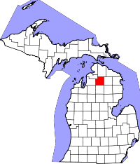 | |
| Village | ||
| Townships | ||
| Unincorporated communities | ||
| Footnotes | ‡This populated place also has portions in an adjacent county or counties | |
Coordinates: 45°08′34″N 84°39′37″W / 45.14278°N 84.66028°W