Vang, Oppland
| Vang kommune | |||
|---|---|---|---|
| Municipality | |||
| |||
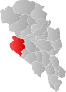 Vang within Oppland | |||
| Coordinates: 61°12′52″N 8°30′15″E / 61.21444°N 8.50417°ECoordinates: 61°12′52″N 8°30′15″E / 61.21444°N 8.50417°E | |||
| Country | Norway | ||
| County | Oppland | ||
| District | Valdres | ||
| Administrative centre | Vang i Valdres | ||
| Government | |||
| • Mayor (2003) | Knut O. Haalien (Sp) | ||
| Area | |||
| • Total | 1,505 km2 (581 sq mi) | ||
| • Land | 1,311 km2 (506 sq mi) | ||
| Area rank | 50 in Norway | ||
| Population (2004) | |||
| • Total | 1,616 | ||
| • Rank | 360 in Norway | ||
| • Density | 1/km2 (3/sq mi) | ||
| • Change (10 years) | -7.4 % | ||
| Demonym(s) | Vangsgjelding[1] | ||
| Time zone | CET (UTC+1) | ||
| • Summer (DST) | CEST (UTC+2) | ||
| ISO 3166 code | NO-0545 | ||
| Official language form | Nynorsk | ||
| Website |
www | ||
|
| |||


Vang is a municipality in Oppland county, Norway. It is part of the traditional region of Valdres. The administrative centre of the municipality is the village of "Vang i Valdres". The municipality of Vang was established on 1 January 1838 (see formannskapsdistrikt).
General information
Name
The municipality (originally the parish) is named after the old Vang farm (Old Norse: Vangr), since the first church was built here. The name is identical with the word vangr which means "field" or "meadow".[2]
Coat-of-arms
The coat-of-arms was granted in 1987. It was originally the seal of a medieval nobleman from the district, Sigvat of Leirhol.[3]
History
Vang, like the rest of Valdres, was originally populated by migrants from Vestlandet. In 1153, recognizing this, Cardinal Breakspear included these valleys in the diocese of Stavanger.[4]
The ancient church of Vang was the site of a legal court (thing) held by King Haakon VI in 1368. Here, he settled a boundary dispute. The boundary stone which resulted stands to this day.[4]
High up the slopes of Filefjell is the site of Nystua, where travellers found refuge as they passed across the divide into Vestlandet. On the other side of the pass, Maristua was erected at the direction of Queen Margaret circa 1390. Although Nystua is first mentioned in 1627, it is undoubtedly older. These refuges were maintained by the state until 1830.[4]
Smeddalen (Smith's Valley) immediately to the west of Nystua, was for centuries the site of the church of St. Thomas på Filefjell. The earliest reference to it is in 1615, but it was apparently a stave church, so would have been much older. According to F.N. Stagg “It was reconditioned (c. 1615)… the priest at Vang preached there once a year–on July 2nd… many sought cures for their ailments in the miraculous powers possessed by splinters from its timbers…”[4] A market grew up near the church as a result of the July 2nd service. “Horses were traded, races run, heavy drinking indulged in and many a fight ensued.”[4] Markets continued to be held near the church until the 19th century, but as a result of fighting and general unrest in connection with the market days the church was torn down in 1808. A new church was built on the site in 1971.[4]
Geography
Vang is bordered to the north by the municipalities of Lom and Vågå, to the east by Øystre Slidre, to the southeast by Vestre Slidre, to the south by Hemsedal (in Buskerud county), and to the west by Lærdal and Årdal (in Sogn og Fjordane county).
Vang is part of the Valdres region in central, southern Norway. This region is situated between Gudbrandsdal and Hallingdal.
Vang municipality is 56 kilometres (35 mi) on a north-south axis and 47.3 kilometres (29.4 mi) on an east-west axis. The highest point is Kalvehøgdi with a height of 2,208 metres (7,244.1 ft) above sea-level.
Three quarters of the region is above 900 metres (3,000 ft). Five percent of the area is covered by water, including Lakes Fleinsendin, Slettningen and Vangsmjøsa. The lowest point is 363 metres (1,191 ft) above sea level.
Attractions
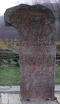
- The Vang stone
- The Ryfossen waterfall
- The Sputrefossen waterfall
Churches
- Høre stave church (built 1180)
- Øye stave church (built 1150-1200)
- St. Thomas Church, Filefjell
- Vang stave church
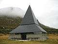 St. Thomas Church
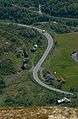 Highway E16
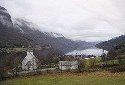
 Lake Vangsmjøsa
 Tyin lake
Trivia
The Veblen and Bunde farmsteads were the homes of the parents of Thorstein Bunde Veblen, from where they emigrated a year before the birth of their son.
References
- ↑ "Navn på steder og personer: Innbyggjarnamn" (in Norwegian). Språkrådet. Retrieved 2015-12-01.
- ↑ Rygh, Oluf (1900). Norske gaardnavne: Kristians amt (Anden halvdel) (in Norwegian) (4 ed.). Kristiania, Norge: W. C. Fabritius & sønners bogtrikkeri. pp. 308 & 313.
- ↑ "Vang Municipality". GoNorway.com. Retrieved 2009-01-03.
- 1 2 3 4 5 6 Stagg, Frank Noel (1956). East Norway and its Frontier. George Allen & Unwin, Ltd.
External links
| Wikimedia Commons has media related to Vang. |
| Look up Vang in Wiktionary, the free dictionary. |
- Municipal fact sheet from Statistics Norway
- Municipal site (Norwegian)
|  | |||||||||||||||||||||||||||||||