Versailles, Ohio
| Versailles, Ohio | |
|---|---|
| Village | |
|
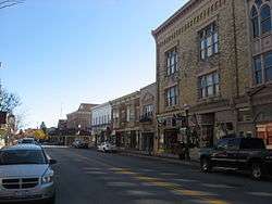
Main Street in Versailles | |
| Motto: "People - Pride - Progress" | |
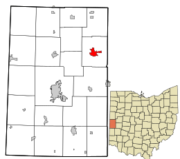 Location in Darke County and the state of Ohio. | |
 Detailed map of Versailles | |
| Coordinates: 40°13′23″N 84°29′6″W / 40.22306°N 84.48500°WCoordinates: 40°13′23″N 84°29′6″W / 40.22306°N 84.48500°W | |
| Country | United States |
| State | Ohio |
| County | Darke |
| Government | |
| • Mayor | Jeff Subler[1] |
| Area[2] | |
| • Total | 1.88 sq mi (4.87 km2) |
| • Land | 1.87 sq mi (4.84 km2) |
| • Water | 0.01 sq mi (0.03 km2) |
| Population (2010)[3] | |
| • Total | 2,687 |
| • Estimate (2012[4]) | 2,661 |
| • Density | 1,436.9/sq mi (554.8/km2) |
| Time zone | Eastern (EST) (UTC-5) |
| • Summer (DST) | EDT (UTC-4) |
| ZIP code | 45380 |
| Area code(s) | 937 |
| Website | www.versaillesohio.cc |
Versailles (/vərˈseɪlz/ vər-SAYLZ) is a village in Darke County, Ohio, United States. It is the only village in Wayne Township. The population was 2,687 at the 2010 census. The proper local pronunciation of the name is ver-sales, with the accent on the second syllable, unlike the French city of the same name.[5][6]
History
Founded in 1819,[7] the village is named after the city of Versailles in France. Versailles was originally named Jacksonville.[8] However, as a large number of early residents were of French descent, it was suggested that the village's name be changed to "Versailles" in memory of their homeland. Versailles became the new name of the village in 1837.
Geography
Versailles is located at 40°13′23″N 84°29′06″W / 40.222964°N 84.485077°W.[9] According to the United States Census Bureau, the village has a total area of 1.88 square miles (4.87 km2), of which 1.87 square miles (4.84 km2) is land and 0.01 square miles (0.03 km2) is water.[2]
Demographics
| Historical population | |||
|---|---|---|---|
| Census | Pop. | %± | |
| 1880 | 1,163 | — | |
| 1890 | 1,385 | 19.1% | |
| 1900 | 1,478 | 6.7% | |
| 1910 | 1,580 | 6.9% | |
| 1920 | 1,563 | −1.1% | |
| 1930 | 1,465 | −6.3% | |
| 1940 | 1,711 | 16.8% | |
| 1950 | 1,812 | 5.9% | |
| 1960 | 2,159 | 19.2% | |
| 1970 | 2,441 | 13.1% | |
| 1980 | 2,384 | −2.3% | |
| 1990 | 2,351 | −1.4% | |
| 2000 | 2,589 | 10.1% | |
| 2010 | 2,687 | 3.8% | |
| Est. 2015 | 2,643 | [10] | −1.6% |
2010 census
As of the census[3] of 2010, there were 2,687 people, 1,083 households, and 686 families residing in the village. The population density was 1,436.9 inhabitants per square mile (554.8/km2). There were 1,150 housing units at an average density of 615.0 per square mile (237.5/km2). The racial makeup of the village was 99.0% White, 0.2% African American, 0.1% Native American, 0.1% from other races, and 0.7% from two or more races. Hispanic or Latino of any race were 0.6% of the population. 45.9% were of German, 33.8% French, and 11.0% Irish ancestries.[12]
There were 1,083 households of which 32.4% had children under the age of 18 living with them, 52.2% were married couples living together, 7.8% had a female householder with no husband present, 3.4% had a male householder with no wife present, and 36.7% were non-families. 33.4% of all households were made up of individuals and 14.6% had someone living alone who was 65 years of age or older. The average household size was 2.39 and the average family size was 3.06.
The median age in the village was 39.8 years. 25.9% of residents were under the age of 18; 5.9% were between the ages of 18 and 24; 24.6% were from 25 to 44; 24.2% were from 45 to 64; and 19.4% were 65 years of age or older. The gender makeup of the village was 47.7% male and 52.3% female.
2000 census
As of the census[13] of 2000, there were 2,589 people, 1,061 households, and 687 families residing in the village. The population density was 1,482.5 people per square mile (571.2/km2). There were 1,109 housing units at an average density of 635.0 per square mile (244.7/km2). The racial makeup of the village was 99.38% White, 0.04% African American, 0.12% Native American, 0.08% Asian, 0.12% from other races, and 0.27% from two or more races. Hispanic or Latino of any race were 0.12% of the population.
There were 1,061 households out of which 31.6% had children under the age of 18 living with them, 54.5% were married couples living together, 7.6% had a female householder with no husband present, and 35.2% were non-families. 32.4% of all households were made up of individuals and 16.0% had someone living alone who was 65 years of age or older. The average household size was 2.35 and the average family size was 3.00.
In the village the population was spread out with 25.5% under the age of 18, 6.8% from 18 to 24, 28.4% from 25 to 44, 19.0% from 45 to 64, and 20.2% who were 65 years of age or older. The median age was 37 years. For every 100 females there were 90.9 males. For every 100 females age 18 and over, there were 85.3 males.
The median income for a household in the village was $37,908, and the median income for a family was $47,717. Males had a median income of $32,440 versus $25,194 for females. The per capita income for the village was $18,275. About 3.5% of families and 5.3% of the population were below the poverty line, including 5.1% of those under age 18 and 9.3% of those age 65 or over.
Government
Versailles' municipal building, the Versailles Town Hall and Wayne Township House, is listed on the National Register of Historic Places.
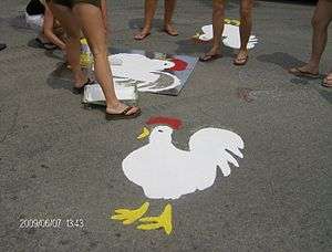
Poultry Days
Versailles is also known for hosting its yearly Poultry Days festival on the second full weekend of June. The festival consists of crowning a "Ms. Chick" and "Little Miss Chick", a carnival, a parade, the production of over 25,000 slow roasted chicken dinners, and the Poultry Days Ultimate tournament.[14][15]
Education
There is one school building in Versailles. The building houses Elementary, Middle and Jr./Sr. High School. The new school was finished in 2010 and is still in the Versailles Exempted School district. The schools new address is 280 Marker Road. The school was paid for by the Versailles people in tax dollars. [16]
References
- ↑ Baker, Steve (2008-10-13). "New EMS Facility In Versailles Dedicated To Past Volunteers". WHIOTV.com. Retrieved 2010-02-04.
- 1 2 "US Gazetteer files 2010". United States Census Bureau. Archived from the original on January 24, 2012. Retrieved 2013-01-06.
- 1 2 "American FactFinder". United States Census Bureau. Retrieved 2013-01-06.
- ↑ "Population Estimates". United States Census Bureau. Archived from the original on June 17, 2013. Retrieved 2013-06-17.
- ↑ Mark Dawidziak. "Bay Village-born TV star Patricia Heaton takes her act online with new web series, 'Versailles'", The Plain Dealer, May 6, 2011.
- ↑ A Pronunciation Guide to Places in Ohio, E. W. Scripps School of Journalism (accessed 2012-09-19).
- ↑ Mangus, Michael; Herman, Jennifer L. (2008). Ohio Encyclopedia. North American Book Dist LLC. p. 564. ISBN 978-1-878592-68-2.
- ↑ Wilson, Frazer Ells (1914). History of Darke County, Ohio, from its earliest settlement to the present time, Vol. 1. Milford, Ohio: Hobart Publishing Company. p. 608.
- ↑ "US Gazetteer files: 2010, 2000, and 1990". United States Census Bureau. 2011-02-12. Retrieved 2011-04-23.
- ↑ "Annual Estimates of the Resident Population for Incorporated Places: April 1, 2010 to July 1, 2015". Retrieved July 2, 2016.
- ↑ "Census of Population and Housing". Census.gov. Archived from the original on May 11, 2015. Retrieved June 4, 2015.
- ↑ http://factfinder2.census.gov/faces/tableservices/jsf/pages/productview.xhtml?pid=ACS_10_5YR_DP02&prodType=table
- ↑ "American FactFinder". United States Census Bureau. Archived from the original on September 11, 2013. Retrieved 2008-01-31.
- ↑ Versailles Poultry Days
- ↑ "Poultry Days wings its way to Versailles: 60th anniversary of the 'fowl' event" Archived June 13, 2011, at the Wayback Machine., WDTN, June 9, 2011.
- ↑ Building For Our Future Archived September 23, 2009, at the Wayback Machine., Versailles Exempted Village Schools, 2008. Accessed 2009-01-10.
External links
| Wikimedia Commons has media related to Versailles, Ohio. |
- Village website
- History of Versailles and other Darke Co. towns
- Pioneer history of Versailles, Wayne Twp., Darke Co., OH
- Versailles, Ohio Public Schools
Municipalities and communities of Darke County, Ohio, United States | ||
|---|---|---|
| City | 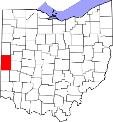 | |
| Villages | ||
| Townships | ||
| Unincorporated communities | ||
| Footnotes | ‡This populated place also has portions in an adjacent county or counties | |