Vijayapuri, Erode
| Vijayapuri | |
|---|---|
| Town | |
|
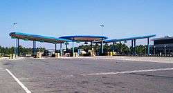
NH47 Toll Plaza at Vijayapuri On Coimbatore-Salem National highway | |
 Vijayapuri  Vijayapuri Location in Tamil Nadu, India | |
| Coordinates: 11°14′N 77°30′E / 11.23°N 77.5°ECoordinates: 11°14′N 77°30′E / 11.23°N 77.5°E | |
| Country |
|
| State | Tamil Nadu |
| District | Erode |
| Elevation | 303 m (994 ft) |
| Population (2011) | |
| • Total | 6,517 |
| Languages | |
| • Official | Tamil |
| Time zone | IST (UTC+5:30) |
| PIN | 638056 |
| Vehicle registration | TN-56 |
Vijayapuri is a census town in Erode district in the Indian state of Tamil Nadu. It is located on National Highway-47 between Perundurai and Perumanallur.
Geography
Vijayapuri (also known as Vijayamangalam) is located at 11°14′N 77°30′E / 11.23°N 77.5°E[1] along NH-47 (bypass). It is the junction point for Tiruppur road and Coimbatore Road towards Salem. New toll plaza on four lane road is located very close to Vijayamangalam on Coimbatore-Salem section. It has an average elevation of 303 metres (994 feet).
It is located 33 km towards west from District headquarters Erode. 12 km from Perundurai. 422 km from State capital Chennai. Sakthi Nagar ( 1 km ), Mettupudur ( 1 km ), Moongilpalayam ( 1 km ), Ponmudi ( 5 km ), Periyaveerasangili (4 km), Karandipalayam ( 5 km ) are the nearby Villages to Vijayamangalam. Vijayamangalam is surrounded by Uttukkuli Taluk towards South, Chennimalai Taluk towards East, Tiruppur Taluk towards west, Nambiyur Taluk towards west .
Uthukuli, Perumanallur, Tiruppur, Erode, Gobichettipalayam are the nearby Cities to Vijayamangalam.
Demographics
As of 2011 India census,[2] Vijayapuri had a population of 6517. As per 2001 census, males constitute 52% of the population and females 48%. Vijayapuri has an average literacy rate of 68%, higher than the national average of 59.5%: male literacy is 76%, and female literacy is 59%. In Vijayapuri, 10% of the population is under 6 years of age.
How To Reach
Vijyamangalam is well connected with Roadways and Railways.
Salem To Ernakulam Highway (NH47) passes through this city. So, this Town is well connected by Roadways. The city connects Salem, Erode, Perundurai, Avinashi, Kangayam, Bhavani, Coimbatore and Tirupur by roadways.
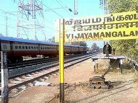
Vijayamangalam Railway Station (VZ), Uthukuli Railway Station, Perundurai Railway Station are the very nearby railway stations to Vijayamangalam. However Erode Junction railway station is major railway station 30 km near to Vijayamangalam.
Temples
- Sri Chandra prabha Theerthangar Temple
- Sri Nageswaraswamy Shiva Temple
- Sri Karivaradharaja Perumal Temple
- Sri Vijayapuri Amman Temple
- Arasanna Malai Agneeshwarar Temple(Kongampalayam)
Loom City
The major Occupation around Vijayamangalam and surrounding areas is Weaving and Agriculture. A lot of Handlooms, Power Looms and Automatic Loom are seen running as Small and medium sized business around this area. The textiles are sold in Kerala, Andhra Pradesh and North India. The major market of the produced textiles are sold in Erode city textile market called Gani textile market.
Educationl Institutions near Vijayamangalam
- Sasurie College of Engineering
- Kongu Engineering College
- Institute of Road & Transport Technology
- IRT Perundurai Medical College
- Bharathi Matriculation Higher Secondary School
- Vijay Vikas International School
References
- ↑ Falling Rain Genomics, Inc - Vijayapuri
- ↑ "Census of India 2001: Data from the 2001 Census, including cities, villages and towns (Provisional)". Census Commission of India. Archived from the original on 2004-06-16. Retrieved 2008-11-01.