Tiruppur
| Tiruppur திருப்பூர் | |
|---|---|
| City | |
| Nickname(s): Knit Wear Capital of India, Textile City | |
 Tiruppur Location in Tamil Nadu, India | |
| Coordinates: 11°07′N 77°20′E / 11.11°N 77.34°ECoordinates: 11°07′N 77°20′E / 11.11°N 77.34°E | |
| Country |
|
| State | Tamil Nadu |
| Region | Kongu Nadu |
| District | Tiruppur |
| Government | |
| • Mayor | A. Visalakshi[1] |
| • Deputy mayor | S. Gunasekaran[2] |
| • Corporation commissioner | Asokan[3] |
| Area[4] | |
| • City | 159.6 km2 (61.6 sq mi) |
| Area rank | 6 |
| Population (2011)[5] | |
| • City | 877,778[6] |
| • Rank | 6 |
| • Metro[7] | 963,173 |
| Languages | |
| • Official | English, Tamil |
| Time zone | IST (UTC+5:30) |
| PIN | 6416xx |
| Telephone code | +91-421 |
| Vehicle registration | TN-39, TN-42 |
| Website |
tiruppurcorporation |
Tiruppur or Tirupur ([t̪ɪɾɨppuːr] ![]() Tirupur.ogg ) is a city in the Kongu Nadu region of the Indian state of Tamil Nadu.[8] Tiruppur is the administrative headquarters of Tiruppur district and the Sixth largest urban agglomeration in Tamil Nadu. Located on the banks of Noyyal River, it has been ruled at different times, by the Early Pandyas, Medieval Cholas, Later Cholas, Vijayanagar Empire, Madurai Nayaks, Mysore Kingdom and the British. It is situated at the centre of the South Indian Peninsula, about 450 kilometres (280 mi) southwest of the state capital Chennai and about 50 kilometres (31 mi) east of Coimbatore.
Tirupur.ogg ) is a city in the Kongu Nadu region of the Indian state of Tamil Nadu.[8] Tiruppur is the administrative headquarters of Tiruppur district and the Sixth largest urban agglomeration in Tamil Nadu. Located on the banks of Noyyal River, it has been ruled at different times, by the Early Pandyas, Medieval Cholas, Later Cholas, Vijayanagar Empire, Madurai Nayaks, Mysore Kingdom and the British. It is situated at the centre of the South Indian Peninsula, about 450 kilometres (280 mi) southwest of the state capital Chennai and about 50 kilometres (31 mi) east of Coimbatore.
Tiruppur is administered by municipal corporation which was established in 2008 and the total area of the corporation is 159.6 km2 divided into 60 wards. The total population of the city as per the 2011 census is 444,352. Tiruppur is a part of the Tiruppur constituency that elects its member of parliament.
Tiruppur is a major textile and knit wear hub contributing to 90% of total cotton knit wear exports from India.[9] The textile industry provides employment to over six lakh people and contributed to exports worth ₹200 billion (US$3.0 billion) in 2014-15.[10][11]
Etymology
The name Tiruppur is said to have emerged during the Mahabharata era. According to history, the cattle herds of Pandavas were stolen by thieves and the same was recaptured by Arjuna's forces resulting in the name "Tiruppur" (Thiruppu : to turn and oor : place in Tamil) meaning "place where they were returned back".[12]
History
Tiruppur formed a part of the Kongu Nadu region ruled by the Cheras during Sangam period.[13][14] The region was part of a prominent Roman trade route that connected east and west coasts of India.[15][16] The medieval Cholas conquered the Kongu Nadu in the 10th century CE and Chola stone carvings mention Kanchi Maanadhi (Noyyal River) and the fertile sand that it deposited on its banks.[17][18][19]
The region came under the rule of the Vijayanagara Empire by the 15th century and later Palayakkarars, the chieftains of Madurai Nayaks ruled the region.[20] In the later part of the 18th century, the region came under the Kingdom of Mysore, following a series of wars with the Madurai Nayak Dynasty. After the defeat of Tipu Sultan in the Anglo-Mysore Wars, the British East India Company annexed the region into the Madras Presidency in 1799.
Tirupur was an agricultural town with irrigated farms and the farmers became small owners of various textile related units during the 1970s. The boom in the textile industry led to an inter woven network of the small scale units leading to growth of the city into a major textile hub.[21] Tiruppur became a municipal corporation in 2008 and a separate Tiruppur district was carved out from parts of Coimbatore district and Erode district in 2009.[22]
Geography
Tiruppur is located at 11°06′27″N 77°20′23″E / 11.1075°N 77.3398°E on the banks of the Noyyal River.[23] It has an average elevation of 295 metres (967 feet) and covers an area of 159.6 km2 (61.6 sq mi).[4]
Demographics
| Historical population | ||
|---|---|---|
| Year | Pop. | ±% |
| 1881 | 3,681 | — |
| 1891 | 5,235 | +42.2% |
| 1901 | 6,056 | +15.7% |
| 1911 | 9,429 | +55.7% |
| 1921 | 10,851 | +15.1% |
| 1931 | 18,059 | +66.4% |
| 1941 | 33,099 | +83.3% |
| 1951 | 52,479 | +58.6% |
| 1961 | 79,773 | +52.0% |
| 1971 | 113,302 | +42.0% |
| 1981 | 165,223 | +45.8% |
| 1991 | 235,661 | +42.6% |
| 2001 | 346,551 | +47.1% |
| 2011 | 444,352 | +28.2% |
| 2015 | 877,778 | +97.5% |
| Sources: | ||
According to 2011 census, Tiruppur had a population of 444,352 with a sex-ratio of 955 females for every 1,000 males, much above the national average of 929.[26] A total of 48,802 were under the age of six, constituting 24,818 males and 23,984 females. Scheduled Castes and Scheduled Tribes accounted for 5.47% and .06% of the population respectively. The average literacy of the city was 78.17%, compared to the national average of 72.99%.[26] The city had a total of 124,617 households. There were a total of 207,358 workers, comprising 490 cultivators, 721 main agricultural labourers, 3,492 in house hold industries, 191,882 other workers, 10,773 marginal workers, 89 marginal cultivators, 74 marginal agricultural labourers, 470 marginal workers in household industries and 10,140 other marginal workers.[27] The area of Tiruppur was expanded in 2011 and the population was 877,778 as per the revised estimate.[6]
As per the religious census of 2011, Tiruppur (M Corp.) had 86.05% Hindus, 10.36% Muslims, 3.33% Christians, 0.03% Sikhs, 0.01% Buddhists, 0.07% Jains, 0.14% following other religions and 0.01% following no religion or did not indicate any religious preference.[28]
Climate
The climate in Tiruppur is tropical with the mean maximum and minimum temperatures varying between 35 to 22 °C (95 to 72 °F). The summer occurs during the months March, April and May when the weather is hot and dry. The maximum temperature during the summer months will be around 35 °C (95 °F) and the minimum temperature will be around 29 °C (84 °F). The monsoon months are the months of June, July and August. These months are mainly characterised by mild showers and a reduced temperature. The post monsoon or winter months are September, October, November, December and January. These months generally have a cool climate and temperatures rarely rise beyond a maximum of around 29 °C (84 °F). The minimum temperature during this season will be around 24 °C (75 °F).[29]
Due to the presence of the Palghat gap, the city receives rainfall from the South-west monsoon in the months from June to August. After a humid September, the North-east monsoon brings rains starts from October which lasts till early November. The average annual rainfall is around 700 mm (28 in) with the North East and the South West monsoons contributing to 47% and 28% respectively to the total rainfall. The soil is predominantly black, which is suitable for cotton cultivation, but it also has some red loamy soil. Tirupur falls under the Class III/IV seismic zone, having experienced a 6.0 Richter scale earthquake in 1900.
| Climate data for Tirupur | |||||||||||||
|---|---|---|---|---|---|---|---|---|---|---|---|---|---|
| Month | Jan | Feb | Mar | Apr | May | Jun | Jul | Aug | Sep | Oct | Nov | Dec | Year |
| Record high °C (°F) | 27 (81) |
30 (86) |
33 (91) |
34 (93) |
33 (91) |
29 (84) |
28 (82) |
27 (81) |
28 (82) |
28 (82) |
27 (81) |
26 (79) |
41 (106) |
| Average high °C (°F) | 24 (75) |
27 (81) |
29 (84) |
28 (82) |
30 (86) |
23 (73) |
25 (77) |
23 (73) |
24 (75) |
23 (73) |
24 (75) |
22 (72) |
30 (86) |
| Average low °C (°F) | 18 (64) |
19 (66) |
21 (70) |
23 (73) |
23 (73) |
22 (72) |
22 (72) |
22 (72) |
22 (72) |
22 (72) |
21 (70) |
19 (66) |
21.2 (70.2) |
| Record low °C (°F) | 15 (59) |
17 (63) |
20 (68) |
22 (72) |
21 (70) |
20 (68) |
20 (68) |
20 (68) |
20 (68) |
19 (66) |
18 (64) |
16 (61) |
12 (54) |
| Average precipitation mm (inches) | 14 (0.55) |
12 (0.47) |
16 (0.63) |
58 (2.28) |
71 (2.8) |
43 (1.69) |
58 (2.28) |
39 (1.54) |
66 (2.6) |
164 (6.46) |
138 (5.43) |
39 (1.54) |
718 (28.27) |
| Source: Tiruppur district collectorate[30] | |||||||||||||
Administration and politics
Corporation officials
|
Tiruppur city is administered by Tiruppur Municipal Corporation headed by a mayor. Tiruppur Municipality was established in 1917 and was upgraded to a municipal corporation in 2008. The city is divided into 60 wards.[32] Each ward is represented by a councillor who is elected by direct election and the mayor of Tiruppur is elected by councillors. The executive wing of the corporation is headed by a corporation commissioner and maintains basic services like water supply, sewage and roads. Law and order is maintained by Tiruppur police headed by a police commissioner of Deputy Inspector General rank. The city police has 7 police stations, 3 traffic police stations and over 1000 personnel.[33] The Tiruppur District Court is the ultimate judicial authority in the district.[34]
Tirupur has two assembly constituencies Tiruppur North and Tiruppur South. Tiruppur is part of Tirupur Lok Sabha constituency which was created during the delimination in 2008 consisting parts of erstwhile Coimbatore, Gobichettipalayam and Palani constituencies.[35]
Economy
Tiruppur is also known as the knitwear capital of India, accounting for 90% of India's cotton knitwear export.[36] It has spurred up the textile industry in India for the past three decades. It contributes to a huge amount of foreign exchange in India. In the Fiscal year 2013, exports were ₹17,500.[37] The city provides employment to around 400,000 workers, with the average salary per worker being around ₹ 9,000 per month.[37]
Special Industrial Parks have been developed to support the textile industry. Nethaji Apparel Park, Tirupur Export Knitwear Industrial Complex, SIDCO Industrial Estate and J.S.Apparel Park are a few that are operational. Nethaji Apparel Park[38] has 53 companies manufacturing knitwear for exports.[39][40] The NAP presently provides employment to 15,000 people and generates export revenue of Rs. 15 billion from the apparels produced in it.[41][42][43] Tirupur Export Knitwear Industrial Complex was established in 1992 and has 189 sheds built over a 4200 square feet area.[36] Some of the world's largest retailers including C&A, Nike, Walmart, Primark, Adidas, Switcher, Polo Ralph Lauren, Diesel, Tommy Hilfiger, M&S, FILA, H&M, Reebok import textiles and clothing from Tiruppur.[44][45]
Welfare
Tiruppur has a good educational infrastructure. The city itself has only a few engineering colleges, but the proximal areas and nearby cities of Coimbatore and Erode augurs well. There are 7 Government hospitals at the taluk level with a total number of 896 beds and a total of 43 Primary Health Centers.[46] in the rural areas[47][48]
- Environmental issues
Tiruppur, like any other industrial town, faces its share of environmental pollution complaints.[49][50] As per the directive of Madras High Court,[51] zero liquid discharge (ZLD) should be strictly followed in Tiruppur knitwear cluster during the effluent treatment process. Failure to implement this order, led to a court ordered closure of all dyeing units and bleaching units.[52] In turn, Tirupur Exporters Association made a representation to the Government that export revenues of ₹ 11 billion were lost and about 100,000 labourers lost their job due to a closure of dyeing units in Tirupur.[53][54]
As per a report by CRISIL, prepared in February 2011, ensuring Zero Liquid Discharge (ZLD), will primarily affect the operational costs of dyeing and bleaching units, increasing it by 7% to 10%.[55] Eventually, by complying with the above order, Tiruppur became the first textile cluster in India to achieve Zero Liquid Discharge in their units.[56] Both the Common Effluent Treatment Plant and Individual Effluent Treatment Plant are in place to treat effluents.[57][58] Farmers in Tiruppur and its hinterland, who have faced the brunt of the indiscriminate discharge of industrial effluents into the water bodies for the past many decades, are yet again becoming concerned.[59] Untreated effluents, mostly containing dyes and chemicals in high concentration, are now seen let off clandestinely once again in large quantities through storm water drains into water bodies or into open areas with the discharge mostly happening during the early morning hours or during rain.[59][60]
Transport
The following are the major highways connecting Tiruppur:
- SH-19 : Palladam - Tiruppur - Avinashi
- SH-37 : Tiruppur - Dharapuram
- SH-196/SH-81 : Tiruppur - Gobichettipalayam
- SH-169 : Tiruppur - Somanur
- SH-172 : Tiruppur - Kangeyam
Tiruppur is well connected by moffusil bus services to all major towns and cities across Tamil Nadu, Kerala, Karnataka and Andhra Pradesh. The city has two major bus stands Old bus stand and New Bus stand.[61] The nearest airport is Coimbatore International Airport (45 km) which has regular flights[62] from/to various domestic destinations like Ahmedabad, Bangalore, Bhubaneswar, Chennai, Delhi, Hyderabad, Kolkata, Kozhikode, Mumbai, Pune and international destinations like Sharjah and Singapore. The Tiruppur railway station falls on the fully electrified and double tracked Salem - Coimbatore broad gauge line and is well connected by trains.
Places of interest
Major temples in Tiruppur were built during the reign Cholas and Pandyas. Sukreeswarar Temple, is a 10th-century temple situated at the outskirts of Tiruppur is considered one of the four 'Sirpa Sthalangal' in Kongu region. An epigraphic study conducted studies at the temple reported that though the temple was built by Pandyas, different inscriptions state that the place was used by tribals to offer poojas to 'Shivalingam' as early as 5th century.[63]
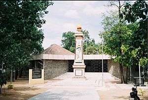
The Town Hall, new railway over-bridge, Tiruppur Kumaran memorial, corporation memorial pillar are some of the landmarks in the Tiruppur city. Some of the common tourist locations outside the city are Sivanmalai, Thirumoorthy Hills, Amaravathi Crocodile Farm, Orathuppalayam Dam, Nanjarayan Tank, Koolipalayam wetlands, Konganagiri hill hock temple, Andipalayam lake, Thirumurugan poondi, Tiruppur Tirupathi temple, Avinashiappar temple and Vazhai Thottathu Ayyankovil.
Notable people
- Tiruppur Kumaran, freedom fighter
References
- 1 2 "Visalakshi becomes first mayor of Tirupur". The Hindu. 22 October 2011.
- 1 2 "S Gunasekaran is Tirupur deputy mayor". The Hindu. 30 October 2011.
- 1 2 "Commissioner, Tiruppur Corporation". Tiruppur corporation. Retrieved 15 June 2011.
- 1 2 "About Corporation of Tirupur". Corporation of Tirupur. Retrieved 26 June 2010.
- ↑ "Provisional Population Totals, Census of India 2011; Cities having population 1 lakh and above" (pdf). Office of the Registrar General & Census Commissioner, India. Retrieved 26 March 2012.
- 1 2 3 "Smart City Challenge-Tiruppur". Government of India. Retrieved 15 December 2015.
- ↑ "Primary Census Abstract - Urban Aglomeration" (XLS). Registrar General and Census Commissioner of India. Retrieved 13 October 2015.
- ↑ "About Tirupur Corporation". Retrieved 15 December 2015.
- ↑ "The New Developments in Tirupur" (PDF). Fairwear Foundation.
- ↑ "Knitwear exports from Tirupur cross Rs 20,000 crore". The Economic Times.
- ↑ "City Guide: Tirupur". India Catalog.Com. Retrieved 24 September 2009.
- ↑ "History of Tiruppur". Government of India.
- ↑ Subramanian, T. S (28 January 2007). "Roman connection in Tamil Nadu". The Hindu. Retrieved 28 October 2011.
- ↑ S. Krishnaswami Aiyangar (2009). Some Contributions of South India to Indian Culture. BiblioBazaar. p. 27. ISBN 978-1-113-17175-7.
- ↑ "Kovai's Roman connection". The Hindu. 8 January 2009. Retrieved 9 June 2010.
- ↑ "On the Roman Trail". The Hindu. 21 January 2008. Retrieved 9 June 2010.
- ↑ "Rivers of Tiruppur". Government of Tamil Nadu. Retrieved 6 September 2015.
- ↑ Vanavarayar, Shankar (21 June 2010). "Scripting history". The Hindu. Retrieved 9 May 2011.
- ↑ M, Soundariya Preetha (30 June 2007). "Tale of an ancient road". The Hindu. Retrieved 9 May 2011.
- ↑ "The land called Kongunadu". The Hindu. 19 November 2005. Retrieved 9 June 2010.
- ↑ "History of Tiruppur". tiruppur.com. Retrieved 6 September 2015.
- ↑ "Tiruppur district formation". Government of Tamil Nadu. Retrieved 6 September 2015.
- ↑ "Falling Rain Genomics, Inc - Tiruppur". Fallingrain.com. Retrieved 24 September 2009.
- ↑ Census of India,series 1,Primary Census Abstract,General Population Part B(i),pp.435;census of India 1991. Government of India. 2001.
- ↑ "TamilNadu Towns, Page 22" (PDF). census India. 2011.
- 1 2 "Census Info 2011 Final population totals". Office of The Registrar General and Census Commissioner, Ministry of Home Affairs, Government of India. 2013. Retrieved 26 Jan 2014.
- ↑ "Census Info 2011 Final population totals - Tiruppur(05904)". Office of The Registrar General and Census Commissioner, Ministry of Home Affairs, Government of India. 2013. Retrieved 26 Jan 2014.
- ↑ "Population By Religious Community - Tamil Nadu" (XLS). Office of The Registrar General and Census Commissioner, Ministry of Home Affairs, Government of India. 2011. Retrieved 13 September 2015.
- ↑ "Overview". Must see India. Retrieved 11 December 2010.
- ↑ "Temperature and Rainfall chart" (PDF). Tiruppur district collectorate. Retrieved 25 May 2010.
- ↑ "Tiruppur gets new Police commissioner". The Hindu. 10 June 2014. Retrieved 6 September 2015.
- ↑ "Local bodies in Tirupur". Retrieved 6 September 2015.
- ↑ "Tiruppur to have its own police commissioner". Times of India. 6 September 2013.
- ↑ "Tiruppur courts". ecourts.gov.in. Retrieved 6 September 2015.
- ↑ "List of Parliamentary and Assembly Constituencies" (PDF). Tamil Nadu: Election Commission of India. Retrieved 11 October 2008.
- 1 2 "Brief Industrial Profile of Tiruppur district" (PDF). DCMSME. Ministry of Micro, Small & Medium Industries, Government of India. Retrieved 3 May 2015.
- 1 2 "Textile hub Tiruppur back on resurgence path". The Economic Times. 22 November 2014. Retrieved 3 May 2015.
- ↑ "Nethaji Apparel Park". Tamil Nadu Government Website. Tamil Nadu Government. Retrieved 3 May 2015.
- ↑ "About TEA". Archived from the original on 5 July 2008. Retrieved 7 February 2013.
- ↑ "Apparel park in Tirupur". Financial express.
- ↑ "Netaji Apparel Park project is a grand success". The Hindu. 7 August 2010. Retrieved 7 February 2013.
- ↑ "Marine discharge facility for dyeing units hailed". The Hindu. Retrieved 15 October 2011.
- ↑ "Industries in Tirupur". Tirupur corporation. Retrieved 15 October 2011.
- ↑ "Cricketing merchandise orders may see a dip during World Cup". Business Standard. 8 December 2014.
- ↑ "A dyeing industry in South India". The National. 14 February 2012.
- ↑ "Department of Public Health & Preventive Medicine". www.tnhealth.org. Tamil Nadu Government. Retrieved 3 May 2015.
- ↑ "List of Government Hospitals". tiruppur.tn.nic.in. Tamil Nadu Government. Retrieved 3 May 2015.
- ↑ "List of Private Hospitals". tiruppur.tn.nic.in. Tamil Nadu Government. Retrieved 3 May 2015.
- ↑ "None". The Judgement Information System. High Court of Madras. Retrieved 3 May 2015.
- ↑ "None". www.indiankanoon.org. Retrieved 3 May 2015.
- ↑ "Tirupur knitwear cluster asked to abide by court directives on pollution". The Hindu. Retrieved 3 May 2015.
- ↑ "Along the banks of Noyyal, farmers in grief". The Times of India. Retrieved 3 May 2015.
- ↑ "dyeing units hailed". The Hindu. Retrieved 15 October 2011.
- ↑ "Dyeing units asked not to work". The Hindu. Retrieved 15 October 2011.
- ↑ "Discharge norms compliance to impact Tirupur-based textile units" (PDF). www.crisil.com. CRISIL. Retrieved 3 May 2015.
- ↑ "Tirupur textile units achieve zero liquid discharge". Business Standard. 7 December 2012. Retrieved 3 May 2015.
- ↑ "Overview, Technical, Business and Management issues of CETP s – Focus on Tanneries & Textiles in Tamilnadu" (PDF). www.igep.in. Retrieved 3 May 2015.
- ↑ "Tiruppur CETP Status" (PDF). www.igep.in. Retrieved 3 May 2015.
- 1 2 "Effluent discharge into water bodies continues in Tirupur". The Hindu. Retrieved 3 May 2015.
- ↑ "TNPCB issues notice to CETP after effluent discharge noticed". The Hindu. 20 April 2015. Retrieved 3 May 2015.
- ↑ "Bus Stand". Tiruppur corporation. Retrieved 12 October 2011.
- ↑ "Coimbatore - Fastest Growing City in India". Coimbatore.com. Retrieved 26 February 2012.
- ↑ "Sukreeswarar Temple". The Hindu. Chennai, India. 1 October 2009. Retrieved 2 October 2009.
External links
| Wikimedia Commons has media related to Tiruppur. |
| State symbols |
|
|---|---|
| Governance |
|
| Topics | |
| Districts |
|
| Major cities | |