Wheatland Township, Ellis County, Kansas
| Wheatland Township | |
|---|---|
| Township | |
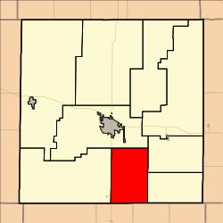 Location in Ellis County | |
| Coordinates: 38°45′44″N 099°15′50″W / 38.76222°N 99.26389°WCoordinates: 38°45′44″N 099°15′50″W / 38.76222°N 99.26389°W | |
| Country | United States |
| State | Kansas |
| County | Ellis |
| Area | |
| • Total | 54.05 sq mi (139.98 km2) |
| • Land | 54.05 sq mi (139.98 km2) |
| • Water | 0 sq mi (0 km2) 0% |
| Elevation | 1,988 ft (606 m) |
| Population (2000) | |
| • Total | 386 |
| • Density | 7.1/sq mi (2.7/km2) |
| GNIS feature ID | 0475294 |
Wheatland Township is a township in Ellis County, Kansas, USA. As of the 2010 census, its population was 386.
Geography
Wheatland Township covers an area of 54.05 square miles (140.0 km2) and contains no incorporated settlements. According to the USGS, it contains one cemetery, Saint Francis.
The streams of Big Timber Creek and Shelter Creek run through this township.
Transportation
Wheatland Township contains two airports or landing strips: Philip Ranch Airport and Stecklein Field.
References
External links
Municipalities and communities of Ellis County, Kansas, United States | ||
|---|---|---|
| Cities | 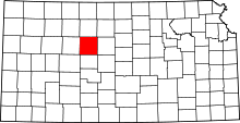 | |
| CDPs | ||
| Unincorporated communities | ||
| Ghost towns | ||
| Townships | ||
This article is issued from Wikipedia - version of the 11/17/2016. The text is available under the Creative Commons Attribution/Share Alike but additional terms may apply for the media files.