Witham Friary

Coordinates: 51°10′08″N 2°21′58″W / 51.169°N 2.366°W
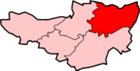
Witham Friary is a small English village and civil parish located between the towns of Frome and Bruton in the county of Somerset. It is in the Cranborne Chase and West Wiltshire Downs Area of Outstanding Natural Beauty and the ancient Forest of Selwood.
History
The parish was part of the hundred of Frome.[2]
The village takes its name from the Witham charterhouse, a Carthusian Priory founded in 1182 by Henry II,[3] which had peripheral settlements including one at Charterhouse and possibly another at Green Ore.[4] It is reputed to be the first Carthusian house in England.[5] One of only nine Carthusian Houses, the priory did not survive the Dissolution of the Monasteries.[6] At the dissolution it was worth £227; the equivalent of £52,000 today (2006).[7] Excavations in 1921 revealed buttressed wall foundations and building rubble including glazed roof and floor tiles. It is a scheduled ancient monument.[4]
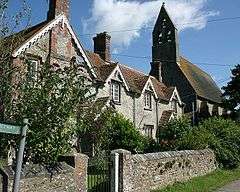
Part of the priory now serves as St Mary's Parish Church.[8] Although the original building dates from around 1200 it was altered in a transitional style in 1828, and then rebuilt and extended 1875 by William White in "Muscular Gothic" style. It has a three-bay nave and continuous one bay apsidal chancel, built of local limestone rubble, supported on each side by four massive flying buttresses. The plastered interior is entered through a Norman style doorway. Inside the church is a scraped octagonal font dating from around 1450. The Jacobean pulpit contains medieval work and there is a royal arms of 1660 at the west end. The stained glass windows contain fragments of medieval glass, with those in the south being made by Sir Ninian Comper. It has been designated by English Heritage as a Grade I listed building.[9]
The former Village Reading Rooms are in a thirteenth-century building which was once a dovecot associated with the Priory. They are grade II* listed building[10] but are included on Mendip District Council Historic Buildings at Risk Register.[11]
The village has older roots. A wealth of nearby tumuli is indicative of ancient human settlement. An archaeological dig in 1985 discovered a neolithic axe and a Roman road.[6] The village is mentioned in the Domesday Book when it supported 11 villagers.[6]
The former railway station at Witham was the end of a branch line through Shepton Mallet, Wells and Cheddar. The station closed in 1963 although the main line to Exeter remains open. The nearest railway station is Bruton. Part of the redundant line that ran to Shepton Mallet now forms the East Somerset Railway.[12]
Governance
The parish council has responsibility for local issues, including setting an annual precept (local rate) to cover the council’s operating costs and producing annual accounts for public scrutiny. The parish council evaluates local planning applications and works with the local police, district council officers, and neighbourhood watch groups on matters of crime, security, and traffic. The parish council's role also includes initiating projects for the maintenance and repair of parish facilities, as well as consulting with the district council on the maintenance, repair, and improvement of highways, drainage, footpaths, public transport, and street cleaning. Conservation matters (including trees and listed buildings) and environmental issues are also the responsibility of the council.
The village falls within the Non-metropolitan district of Mendip, which was formed on 1 April 1974 under the Local Government Act 1972, having previously been part of Frome Rural District,[13] which is responsible for local planning and building control, local roads, council housing, environmental health, markets and fairs, refuse collection and recycling, cemeteries and crematoria, leisure services, parks, and tourism.
Somerset County Council is responsible for running the largest and most expensive local services such as education, social services, libraries, main roads, public transport, policing and fire services, trading standards, waste disposal and strategic planning.
It is also part of the Somerton and Frome county constituency represented in the House of Commons of the Parliament of the United Kingdom. It elects one Member of Parliament (MP) by the first past the post system of election, and part of the South West England constituency of the European Parliament which elects seven MEPs using the d'Hondt method of party-list proportional representation.
Public House

The Seymour Arms is a traditional public house. Purpose-built along with farm buildings in 1866 or 1867 for the Duke of Somerset's estate, it takes its name from the family name of the Duke of Somerset.
The pub is noted by CAMRA because of its beautifully preserved interior, and is included in their National Inventory of Historic Pubs.[14]
Water Dispute
Since the 19th century, the village water supply has come from the estate of the Duke of Somerset rather than from a commercial water company. The estate's decision to terminate the supply is a cause for local concern.[15][16]
Geography and Geology
The village lies near the source of the River Frome and at 96 metres above sea level. There is a risk of flooding.[17] The underlying solid geology is Middle Jurassic Cornbrash.
Building the Dream
In 2004 the village hosted a reality television programme broadcast on Channel 4 called Building the Dream, hosted by Linda Barker. Couples competed to win a dream home in the village.[18] A local production company, Zeal, was responsible.[19]
References
- ↑ "Witham Friary Parish". Neighbourhood Statistics. Office for National Statistics. Retrieved 1 January 2014.
- ↑ "Somerset Hundreds". GENUKI. Retrieved 8 October 2011.
- ↑ "Witham Friary Somerset". A Vision of Britain through time. Retrieved 15 December 2015.
- 1 2 Reid, Robert Douglas (1979). Some buildings of Mendip. The Mendip Society. ISBN 0-905459-16-4.
- ↑ "Witham-Friary (St Mary)". British History Online. Retrieved 2 September 2007.
- 1 2 3 "Land adjoining Gramarye, Witham Friary, Somerset." (PDF). Context One Archaeological Services. Archived from the original (PDF) on 20 August 2007. Retrieved 2 September 2007.
- ↑ "Purchasing Power of British Pounds from 1264 to 2006". Measuring worth.com. Retrieved 2 September 2007.
- ↑ "Local History — Witham Friary". Somerset Larders.com. Retrieved 2 September 2007.
- ↑ "Church of St Mary". Images of England. Retrieved 2 September 2007.
- ↑ "Former Village Reading Room, Witham Friary". Images of England. Retrieved 5 September 2016.
- ↑ "Historic Buildings at Risk Register". Mendip District Council. p. Entry 44. Retrieved 5 September 2016.
- ↑ "History of the ESR". East Somerset Railway. Retrieved 2 September 2007.
- ↑ "Frome RD". A vision of Britain Through Time. University of Portsmouth. Retrieved 4 January 2014.
- ↑ "South West England". CAMRA National Inventory of Heritage Pubs. Retrieved 2 September 2007.
- ↑ Morris, Steven (31 May 2006). "Village left high and dry by lord of manor". The Guardian. Retrieved 2 September 2007.
- ↑ "Water Supply to the village of Witham Friary". Mendip District Council. Retrieved 2 September 2007.
- ↑ "Somerset Frome from Witham Friary to Frome". Environment Agency Flood Warning. Retrieved 4 October 2010.
- ↑ "UK Game Shows". Retrieved 28 August 2007.
- ↑ "Zeal TV". Retrieved 28 August 2007.
External links
| Wikimedia Commons has media related to Witham Friary. |