Rode, Somerset

Coordinates: 51°17′05″N 2°16′44″W / 51.2847°N 2.2789°W
Rode (formerly Road) is a village in Somerset, England located 5 miles (8.0 km) northeast of Frome and 5 miles (8.0 km) southwest of Trowbridge. The village was formerly in Wiltshire, before being transferred to neighbouring Somerset.
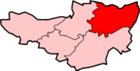
The village lies within a mile of the Wiltshire border and is the easternmost settlement in Somerset. The Wiltshire village of Southwick is only 2 miles (3 km) to the east.
Facilities in the village include a village school, pre-school, shop/post office, physiotherapy and acupuncture clinic and a cricket club, which was founded in about 1895.
There used to be several mills in the village, one of which has now been converted into The Mill pub. Other pubs in Rode are The Cross Keys[2][3] and The Bell.[4] Until 1962, the village was home to Fussell's Brewery, which grew up behind the Cross Keys Inn. It continued to be used a bottling plant and distribution depot by Bass until 1992.[5] The site was eventually sold off to a housing developer despite strong opposition from residents, as was the old site of Rode Tropical Bird Gardens, an animal sanctuary and small zoo, which closed its doors to the public in 2001.[6]
History
The village appears as "Rode" in the Domesday Book, but the spelling was labile from an early date: it is "Roda" in assize rolls of 1201, "la Rode" in a charter roll of 1230; by the 18th Century "Road" was regarded as the usual form. This was reverted to the older spelling "Rode" by Somerset County Council in 1919.[7] The name derives from the Anglo-Saxon rod, meaning a clearing.[8] The parish was part of the hundred of Frome.[9]
Rode rose to prominence as a trading centre on the ceremonial borders of Wiltshire and Somerset, and later became a market town. The old village was positioned around St Lawrence's church along the main thoroughfare (known as Rode Major; now on the ordnance map as "Church Row"). However, many parts of the old village were damaged in a fire and the ruins can be seen in the field adjoining the church.[10]
Rode's prominence was greatest during the 16th and 17th centuries, when the wool milling industry boomed in the South West; a success due largely to the meandering nature of its rivers, which afforded the space for the construction of mill ponds and streams, and because of its close proximity to the international port of Bristol. At one point Rode was home to four or five wool mills which created great wealth for the village and funded the construction of many large houses in the village, such as Rode Manor, Langham House, Milfield House and Southfield House. During the 16th, 17th and 18th centuries the village centre thrived enough for Rode to be known as a market town.[11]
Possibly the greatest single moment in the milling industry of Rode was during the 18th century when a consortium of Rode mills won a competition to make Queen Charlotte's dress. In winning the prize a mill in the village invented the dye Royal Blue and received a certificate to sell it under that name.[12]
By the middle to the end of the 19th century, the wool mills of Rode were struggling, like many in the South West region, as a result of both the industrial revolution and the invention of steam power, which caused mills to move to northern industrial centres.[13]
Rode is now largely a dormitory village, offering good access to Bristol, Bath, Trowbridge and Frome.[14]
The Murder at Road Hill House
Rode was the scene of one of the most infamous murders of the 19th century when Constance Kent was arrested by order of the town magistrates for the murder of her 3-year-old half-brother at Road Hill House (now Langham House). The case was investigated by Detective Inspector Jack Whicher. Although released at her committal hearing, Kent was later to confess, was charged and received the mandatory death sentence. This was commuted to life imprisonment, of which she served twenty years.[15][16]
Governance
The parish council has responsibility for local issues, including setting an annual precept (local rate) to cover the council’s operating costs and producing annual accounts for public scrutiny. The parish council evaluates local planning applications and works with the local police, district council officers, and neighbourhood watch groups on matters of crime, security, and traffic. The parish council's role also includes initiating projects for the maintenance and repair of parish facilities, as well as consulting with the district council on the maintenance, repair, and improvement of highways, drainage, footpaths, public transport, and street cleaning. Conservation matters (including trees and listed buildings) and environmental issues are also the responsibility of the council.
The village falls within the Non-metropolitan district of Mendip, which was formed on 1 April 1974 under the Local Government Act 1972, having previously been part of Frome Rural District,[17] which is responsible for local planning and building control, local roads, council housing, environmental health, markets and fairs, refuse collection and recycling, cemeteries and crematoria, leisure services, parks, and tourism.
Somerset County Council is responsible for running the largest and most expensive local services such as education, social services, libraries, main roads, public transport, policing and fire services, trading standards, waste disposal and strategic planning.
The village falls in the 'Rode and Norton St Philip' electoral ward. The ward has its northern edge in Norton St Philip, then it stretches south through Rode to Lullington. The total population of the ward taken at the 2011 census was 2,2227.[18]
It is also part of the Somerton and Frome county constituency represented in the House of Commons of the Parliament of the United Kingdom. It elects one Member of Parliament (MP) by the first past the post system of election, and part of the South West England constituency of the European Parliament which elects seven MEPs using the d'Hondt method of party-list proportional representation.
Religious sites
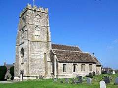
The Church of St Lawrence dates from the late 14th and early 15th century. It was restored in 1874 by Charles Edward Davis and is a Grade I listed building.[19] There is also a Baptist-Methodist chapel, dating from 1809, which has Grade II listed building status for the gates and walls.[20]
Christ Church at Rode Hill was built in 1824 but was declared redundant in 1995 and is now a house and violin shop.[21]
Landmarks
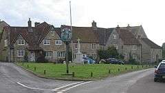
Rode is home to two village pumps,[22][23] a mounted plough, a wellhead pump,[24][25] an elaborate village sign,[26] a flagpole and a war memorial in the form of a cross.[27] The latter three are all placed on the village green.
A three arch packhorse bridge crosses the River Frome. It is 48 inches (1,200 mm) wide and has a total span of 63 feet (19 m).[28]
References
- ↑ "Rode Parish". Neighbourhood Statistics. Office for National Statistics. Retrieved 1 January 2014.
- ↑ "Cross Keys". Images of England. English Heritage. Retrieved 25 November 2006.
- ↑ "The Cross Keys Pub and Restaurant in Rode, Frome". crosskeysrode.co.uk.
- ↑ "The Bell Inn". Images of England. English Heritage. Retrieved 25 November 2006.
- ↑ Ely, S.; Jones, B. "Brewery History" (PDF). The Journal of the Brewery History Society. Retrieved 21 August 2011.
- ↑ "Tropical Bird Gardens, Rode". Zoos UK. Retrieved 21 August 2011.
- ↑ "Chronology of Rode". Rode History. Retrieved 13 June 2014.
- ↑ Ekwall, 1936/1984, The Concise Oxford Dictionary of English Place-Names, p. 389.
- ↑ "Somerset Hundreds". GENUKI. Retrieved 8 October 2011.
- ↑ "Church Row Farm, Frome Road, Rode, Somerset: An Archaeological Evaluation" (PDF). Thames Valley Archaeological Services. Retrieved 12 February 2011.
- ↑ "Rode". A Vision of Britain Through Time. University of Portsmouth. Retrieved 12 February 2011.
- ↑ "The Origin of Royal Blue". Rode History. Retrieved 12 February 2011.
- ↑ "Rode". Information Britain. Retrieved 12 February 2011.
- ↑ "Vision for Frome Baseline Study" (PDF). Vision for Frome. Retrieved 21 August 2011.
- ↑ Crittall, Elizabeth (1965). "North Bradley". British History Online. University of London and History of Parliament Trust. Retrieved 26 July 2008.
- ↑ Summerscale, Kate (2008). The Suspicions of Mr Whicher. London: Bloomsbury. ISBN 978-0-7475-8215-1.
- ↑ "Frome RD". A vision of Britain Through Time. University of Portsmouth. Retrieved 4 January 2014.
- ↑ "Rode and Norton St Philip ward 2011.Retrieved 7 March 2015".
- ↑ "Church of St Lawrence". Images of England. Retrieved 25 November 2006.
- ↑ "Methodist Church". Images of England. English Heritage. Retrieved 28 March 2011.
- ↑ "Christchurch House". Andrew Hooker Violins. Retrieved 30 October 2015.
- ↑ "rode pumps". villagepumps.org.uk.
- ↑ "The History of Rode, Somerset". rodevillage.com.
- ↑ MINUTES OF THE MEETING OF RODE PARISH COUNCIL HELD ON TUESDAY 5 FEBRUARY 2013
- ↑ Wellhead Pump in Rode, Somerset. UK. YouTube. 12 October 2013.
- ↑ Maurice Pullin. "2008 : Rode Village Sign (C) Maurice Pullin :: Geograph Britain and Ireland". geograph.org.uk.
- ↑ Good Stuff. "War Memorial - Rode - Somerset - England - British Listed Buildings". britishlistedbuildings.co.uk.
- ↑ Hinchliffe, Ernest (1994). Guide to the Packhorse Bridges of England. Cicerone. pp. 151–152. ISBN 978-1852841430.
External links
| Wikimedia Commons has media related to Rode, Somerset. |