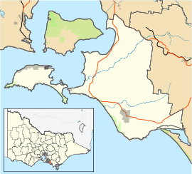
Wonthaggi
| Wonthaggi Victoria | |||||||
|---|---|---|---|---|---|---|---|
 Shopping Strip, McBride Avenue | |||||||
 Wonthaggi | |||||||
| Coordinates | 38°36′20″S 145°35′30″E / 38.60556°S 145.59167°ECoordinates: 38°36′20″S 145°35′30″E / 38.60556°S 145.59167°E | ||||||
| Population | 4,354 (2011 census)[1] | ||||||
| Postcode(s) | 3995 | ||||||
| Elevation | 52 m (171 ft) | ||||||
| Location | |||||||
| LGA(s) | Bass Coast Shire | ||||||
| State electorate(s) | Bass | ||||||
| Federal Division(s) | McMillan | ||||||
| |||||||
Wonthaggi /ˈwɒnθæɡi/ is a seaside[2] town located 132 kilometres (82 mi) south east of Melbourne via the South Gippsland and Bass Highways, in the Bass Coast Shire of Gippsland, Victoria, Australia. Known originally for its coal mining it is now the largest town in South Gippsland, a regional area with extensive tourism, beef and dairy industries. At the 2011 census, it had a population of 4,354.[1]
The name "Wonthaggi" is an Australian Aboriginal name meaning "home" from the Bunurong (south-central Kulin). It was used in the area some time before 1 August 1910 when the town was founded.[3]
History
The Bunurong aboriginal people were custodians of this stretch of coast for thousands of years prior to white settlement. The Boakoolawal clan lived in the Kilcunda area south of the Bass River, and the Yowenjerre were west of the Tarwin River along what is now the Bunurong Marine and Coastal Park. Middens containing charcoal and shellfish mark the location of their campsites along the coast.[4]
Coal was discovered by explorer William Hovell at Cape Paterson in 1826, and was subsequently mined from the Powlett River fields in the region, between 1859 and 1864. However transporting the coal by whale boat through the surf to larger ships anchored offshore proved costly and dangerous and mining activity was soon curtailed. The coastal sands off Wonthaggi occasionally uncover the remains of ships wrecked along the coast.[5]
A tent city was established adjacent to the Powlett River, on what were then known as the Powlett River Coalfields. The tent city had no permanent buildings and healthcare was provided by a Dr Sleeman, who was later instrumental in establishing a permanent hospital in the township of Wonthaggi, proclaimed in 1910.[5]
Much of the coal for the colony of Victoria was sourced from Newcastle and the Hunter Region in New South Wales, along with local supplies from private and co-operative coal mines at Outtrim, Jumbunna and Korumburra in Gippsland. After the 1909-1910 strike by coal miners in the Hunter Valley, the Victorian state government were determined to ensure stability in local supplies of coal. The State Coal Mine and the town of Wonthaggi came into being in 1910 to supply coal for the Victorian Railways.[6] It was one of the largest and most dangerous collieries in Australia.[7] At its peak in 1926 the mine produced 2,435 long tons (2,474 t) per day, with the Victorian Railways buying 90% of production.[8] In 1928, Wonthaggi coal accounted for around 60% of Victorian Railways coal consumption.[9]
A Post Office opened on 11 November 1887 in a nearby area. On 1 August 1910 this office was renamed St Clair and on the same day Powlett Coal Mine Post Office, opened earlier that year, was renamed Wonthaggi. That is when the town was given a permanent name.[10]
Wonthaggi Wind Farm


The Wonthaggi Wind Farm in Campbell Street was built in 2005. It is an environmentally friendly wind power station with six turbines.[11] The Bass Coast Shire Council was opposed to the wind farm along with some local residents. Protesters argued that it would taint the view of Cape Patterson on the trip from Anderson to Wonthaggi and would affect the "recreational tourism and landscape values of the coastline". By September 2005 the six towers had been built, but were themselves a tourist attraction, seen clearly as you drive down the hill towards Wonthaggi from Anderson.[12] The wind farm generates power up to 80% of the time, providing electricity for up to 6000 homes. It can be seen when visiting Williamsons Beach and the Victorian Desalination Plant.[13]
Recreation and tourism
The State Coal Mine in Wonthaggi was operational from 1910 to 1968 and is now operated by Parks Victoria as a tourist attraction and cafe.[14]
- Wonthaggi Golf Course - 18 hole, par 72, ACR 70, easy walk, McKenzie Street[15]
- Wonthaggi Museum [16]
Coastal attractions
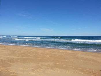
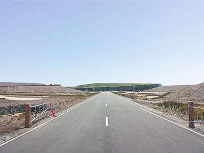
Williamsons Beach on Lower Powlett Road is located next to the Wonthaggi Wind Farm and the Victorian Desalination Plant. The Victorian Desalination Plant also has a 225-hectare park and 8 km of walking, riding and cycling tracks.[4] Seashell collecting is permitted on Wonthaggi Beaches.[17]
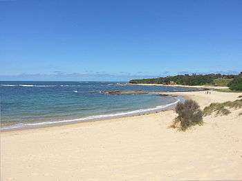
Safety Beach on Surf Beach Road Cape Paterson is a popular beach because it has a modified rockpool for swimming.[18] The rockpool was built by miners in the 1960s, at a time when the environment was less of a priority in Australia.[19]
Harmers Haven and Wreck Beach on Berrys Road are popular for surf and rock fishing. Williamsons Beach and Baxters Beach are popular for fishing day and night, catching mostly Salmon and Mullet. Powlett River mouth is popular for catching Bream, Perch, Salmon and Mullet.[4]
Walking, cycling and horse trotting is the modern use of the old Wonthaggi railway line all year round. The Bass Coast Rail Trail is very flat and begins at the mine whistle airshaft tower in the centre of town and it ends at the roundabout to Phillip Island. Victoria’s only coastal rail trail, it stretches 16 kilometres from Wonthaggi to Anderson.
- Bunurong Marine Park - explore/snorkel, Surf Beach Road, Cape Paterson[20]
- Bunurong Marine National Park - protected state park, explore/snorkel, Inverloch-Cape Paterson Road[20]
Climate
Wonthaggi's location on the north shore of Bass Strait gives it an oceanic climate, with the moderating effect of the ocean allowing a narrower temperature range throughout the year compared to other regions in Victoria. Average daily maximum temperatures range from 23.5 °C in summer to 13.5 in winter. Frost is rare, occurring on average 6 mornings a year.[21]
Education
Wonthaggi has three primary schools and one secondary college. Also Chisholm TAFE,[22] Bass Coast Specialist School,[23] Bass Coast Adult Education Centre,[24] University of the Third Age (U3A) retirees education centre,[25] and Connecting Skills Australia (CSA) specialist developmental school, support and employment services/training.[26] Plans are underway for a new tertiary education facility.[27]
Facilities
In 1911, miners formed the Wonthaggi Co-operative Workmen's Club. The Wonthaggi Workmens Club entity still exists today on Graham Street, run as a family bistro, pub and functions/events venue. Miners were also prominent in establishing the local hospital, friendly society dispensary, trade union theatre, and a co-operative store, and in supporting miners in New Zealand in the 1912 Waihi miners' strike. The Union theatre slowly fell into disrepair following the closure of the mines, and in 1980 it was destroyed by fire.[4] It was one of the last buildings associated with the mining era in the town. The Miners' Union donated the land where the Union Theatre had stood to the council, on the condition that any building erected on the site should perpetually bear the name "Union". It is now the site for the Wonthaggi Union Community Arts Centre.
The town has many large chain stores; RACV Inverloch Resort (accommodation choices & restaurant/Sunday buffet), four major supermarkets, cafes, restaurants, pubs, clubs, a hospital hotels and markets.[28]
Notable people
- James Phelan (author)
- Ian Harvey (Australian cricketer)
- Darren Berry (Victorian cricketer)
- Jarryd Blair (Collingwood footballer)
- Trent West (Former Geelong footballer current Brisbane footballer)
- Angus McLaren (actor)
- James Mollison (acting director National Gallery of Australia/Commonwealth Art Advisor)
References
- 1 2 Australian Bureau of Statistics (31 October 2012). "Wonthaggi (State Suburb)". 2011 Census QuickStats. Retrieved 2013-11-13.
- ↑ Google Maps, retrieved 2014-03-21
- ↑ Wonthaggi Community Profile, retrieved 2013-11-03
- 1 2 3 4 Bass Coast Information Centres, retrieved 2013-10-28
- 1 2 "Wonthaggi Coal Mines". Victorian Railways. Museum Victoria. Retrieved 2013-07-14.
- ↑ "Wonthaggi Coal Mines". Victorian Railways. Museum Victoria. Retrieved 2013-07-14.
- ↑ Wonthaggi History Check
|url=value (help), retrieved 2013-11-17 - ↑ Lee, Robert (2007). The Railways of Victoria 1854-2004. Melbourne University Publishing Ltd. p. 132. ISBN 978-0-522-85134-2.
- ↑ "Railways Administration.". The Argus (Melbourne, Vic. : 1848 - 1956). Melbourne, Vic.: National Library of Australia. 13 July 1928. p. 13. Retrieved 3 January 2013.
- ↑ "Post Office List". Premier Postal History. Retrieved 27 October 2013.
- ↑ Wonthaggi Wind Farm, Clean Energy Council, retrieved 2013-10-28
- ↑ Council admits defeat in wind turbine fight. 06/09/2005. ABC News Online
- ↑ Victorian Desalination Plant, retrieved 2013-11-04
- ↑ Parks Victoria, retrieved 2013-10-27
- ↑ Wonthaggi Golf Club, retrieved 2013-11-11
- ↑ Wonthaggi Historical Society, retrieved 2013-11-11
- ↑ Department Of Environment And Primary Industries, retrieved 2013-11-03
- ↑ CPCP, retrieved 2013-11-14
- ↑ Terry Gitcham Allen. Powlett Tent Town. p. 63. Retrieved 13 December 2013.
- 1 2 Parks Victoria, retrieved 2013-11-13
- ↑ "Australian Weather News". Retrieved 2010-02-11.
- ↑ Chisholm TAFE, retrieved 2013-10-28
- ↑ Bass Coast Specialist School, retrieved 2013-10-28
- ↑ Bass Coast Adult Education Centre, retrieved 2013-10-28
- ↑ University Of The Third Age (U3A), retrieved 2013-10-28
- ↑ Connecting Skills Australia, retrieved 2013-11-06
- ↑ Bass Coast Shire, retrieved 2013-11-11
- ↑ Street Advisor, retrieved 2013-10-28
External links
![]() Media related to Wonthaggi, Victoria at Wikimedia Commons
Media related to Wonthaggi, Victoria at Wikimedia Commons
| Wikivoyage has a travel guide for Wonthaggi. |