Yeşilırmak (river)
| Yeşilırmak River | |
|---|---|
 Yeşilırmak | |
| Country | Turkey |
| Basin | |
| Main source | Sivas |
| River mouth |
Black Sea 0 m (0 ft) |
| Physical characteristics | |
| Length | 418 km (260 mi) |
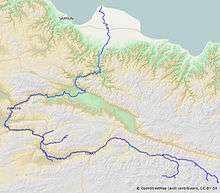
The Yeşilırmak (Turkish: Yeşilırmak, "Green River"; classical Greek: Ίρις, Iris) is a river in northern Turkey. From its source north-east of Sivas, it flows past Tokat and Amasya, and reaches the Black Sea at Samsun after 418 km (260 mi).
Its tributaries include the Çekerek (ancient Scylax) and the Kelkit (ancient Lycus).
Strabo's Geographica describes it as flowing through Comana Pontica, the plain of Dazimonitis (Kaşova) (40°17′41″N 36°17′48″E / 40.2947808°N 36.296736°E), and Gaziura (probably modern Turhal)[1] before receiving the waters (40°33′42″N 35°45′34″E / 40.5615797°N 35.7595217°E) of the Scylax, then flowing through Amaseia (Amasya) before reaching the valley of Phanaroea.[2]
Notes
- ↑ Phytoplankton and seasonal variations of the River Yeşilırmak, Amasya, Turkey (9 May 2003)
- ↑ Strabo 12:3:15 at Perseus
| Wikimedia Commons has media related to Yeşilırmak River. |
Coordinates: 41°22′54″N 36°39′37″E / 41.3816°N 36.6603°E