Yengisar County
| Yengisar County 英吉沙县 • يېڭىسار ناھىيىسى | |
|---|---|
| County | |
.png) Location of the county | |
| Country | China |
| Province | Xinjiang |
| Prefecture-level divisions | Kashgar Prefecture |
| Time zone | China Standard (UTC+8) |
| Yangihissar | |||||||||
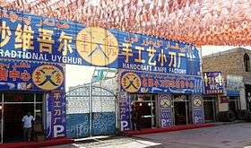
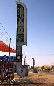 Signs advertising Yengisar's famous knives. | |||||||||
| Chinese name | |||||||||
|---|---|---|---|---|---|---|---|---|---|
| Traditional Chinese | 英吉沙縣 | ||||||||
| Simplified Chinese | 英吉沙县 | ||||||||
| |||||||||
| Uyghur name | |||||||||
| Uyghur |
يېڭىسار ناھىيىسى | ||||||||
| |||||||||
Yengisar County is a county in the Xinjiang Uyghur Autonomous Region in northwestern China. It is under the administration of the Kashgar Prefecture. It contains an area of 3,373 km2. As of the 2002 census, it had a population of 230,000.
The county seat is the city of Yengisar, a town that is best known among the local Uyghurs for its handmade knives. The finely-tuned skill of knife making used to be passed down among generations in Yengisar[1] but is slowly dying due to China's strict response to deadly clashes in the Xinjiang region.[2]
Yengisar was also historically known as Yangi Hissar.
History
The Battle of Yangi Hissar took place there, In April 1934, Ma Zhancang led the Chinese Muslim 36th division to attack the Turkic Muslim Uighur forces at Yangi Hissar, wiping out the entire Uighur force of 500, and killing the Emir Nur Ahmad Jan Bughra.[3][4]
Wildlife
The city of Yengisar gave its name to a lizard species, Yangihissar gecko (Cyrtopodion elongatum), which occurs throughout eastern Central Asia, including Xinjiang and Gansu Province.
Transportation
Yengisar is served by China National Highway 315 and the Southern Xinjiang Railway.
See also
References
- ↑ Summers, Josh. "The Uyghur Knife and My Visit to Yengisar". FarWestChina.com. Retrieved June 16, 2016.
- ↑ Makinen, Julie (September 17, 2014). "For China's Uighurs, Knifings Taint an Ancient Craft". Los Angeles Times. Retrieved June 17, 2016.
- ↑ "Fighting Continues Tungan Troops Still Active in Chinese Turkestan". The Montreal Gazette. 10 May 1934.
- ↑ Andrew D. W. Forbes (1986). Warlords and Muslims in Chinese Central Asia: a political history of Republican Sinkiang 1911-1949. Cambridge, England: CUP Archive. p. 123. ISBN 0-521-25514-7. Retrieved 2010-06-28.
Coordinates: 38°55′33″N 76°10′17″E / 38.92583°N 76.17139°E