Yukuhashi, Fukuoka
| Yukuhashi 行橋市 | |
|---|---|
| City | |
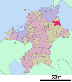
 Location of Yukuhashi in Fukuoka Prefecture | |
 Yukuhashi Location in Japan | |
| Coordinates: 33°44′N 130°59′E / 33.733°N 130.983°ECoordinates: 33°44′N 130°59′E / 33.733°N 130.983°E | |
| Country | Japan |
| Region | Kyushu |
| Prefecture | Fukuoka Prefecture |
| Area | |
| • Total | 69.83 km2 (26.96 sq mi) |
| Population (June 30, 2005) | |
| • Total | 72,005 |
| • Density | 1,000/km2 (2,700/sq mi) |
| Time zone | Japan Standard Time (UTC+9) |
| Website |
www |
Yukuhashi (行橋市 Yukuhashi-shi) is a satellite city located in Fukuoka Prefecture, Japan, about 25 kilometers southeast of Kitakyushu. The city was founded on October 10, 1954.
As of June 30, 2005, the city has a population of 72,005 (according to the city's official home page) and a population density of 1,002.43 persons per km². The total area is 69.83 km².
History
The hamlet of Maeda in Yukuhashi was the birthplace of Suematsu Kencho.
Transportation
- Air
- Train
- JR Kyushu
- Heisei Chikuhō Railway
- Tagawa Line
- Yukuhashi Station - Miyako-Izumi Station - Imagawa-Kappa Station - Toyotsu Station
- Road
- Expressways
- Higashikyushu Expressway
- Yukuhashi Interchange - Imagawa Interchange/Service Area
- Higashikyushu Expressway
- National highways:
See also
External links
 Media related to Yukuhashi, Fukuoka at Wikimedia Commons
- Yukuhashi City official website (Japanese)
This article is issued from Wikipedia - version of the 6/24/2016. The text is available under the Creative Commons Attribution/Share Alike but additional terms may apply for the media files.