Canton of Zürich
| Kanton Zürich | ||
|---|---|---|
| Canton of Switzerland | ||
| ||
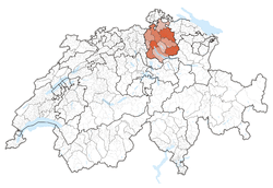 Location in Switzerland | ||
|
Map of Zürich 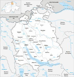 | ||
| Coordinates: 47°22′N 8°33′E / 47.367°N 8.550°ECoordinates: 47°22′N 8°33′E / 47.367°N 8.550°E | ||
| Capital | Zurich | |
| Subdivisions | 169 municipalities, 12 districts | |
| Government | ||
| • Executive | Regierungsrat (7) | |
| • Legislative | Cantonal Council (180) | |
| Area[1] | ||
| • Total | 1,729 km2 (668 sq mi) | |
| Population (12/2015)[2] | ||
| • Total | 1,463,459 | |
| • Density | 850/km2 (2,200/sq mi) | |
| ISO 3166 code | CH-ZH | |
| Highest point | 1,292 m (4,239 ft): Schnebelhorn | |
| Lowest point | 332 m (1,089 ft): Rhine at the border in Weiach | |
| Joined | 1351 | |
| Languages | German | |
| Website | ZH.ch | |

The Canton of Zürich (German: Kanton ![]() Zürich ) has a population (as of 31 December 2015) of 1,463,459.[2] The canton is located in the northeast of Switzerland and the city of Zürich is the capital of the canton. The official language is German. The local Swiss German dialect called Züritüütsch is commonly spoken. In English the name of the canton is often written without an umlaut.
Zürich ) has a population (as of 31 December 2015) of 1,463,459.[2] The canton is located in the northeast of Switzerland and the city of Zürich is the capital of the canton. The official language is German. The local Swiss German dialect called Züritüütsch is commonly spoken. In English the name of the canton is often written without an umlaut.
History
The Prehistoric pile dwellings around Zürichsee comprises 11 of total 56 Prehistoric pile dwellings around the Alps in Switzerland, that are located around Zürichsee in the cantons of Schwyz, St. Gallen and Zürich.[3][4] Located on Zürichsee lakeshore, there are Freienbach–Hurden Rosshorn, Freienbach–Hurden Seefeld, Rapperswil-Jona/Hombrechtikon–Feldbach, Rapperswil-Jona–Technikum, Erlenbach–Winkel, Meilen–Rorenhaab, Wädenswil–Vorder Au, Zürich–Enge Alpenquai, Grosser Hafner and Kleiner Hafner. Because the lake has grown in size over time, the original piles are now around 4 metres (13 ft) to 7 metres (23 ft) under the water level of 406 metres (1,332 ft). Also on the small area of about 40 square kilometres (15 sq mi) around Zürichsee, there also the settlements Greifensee–Storen/Wildsberg on Greifensee and Wetzikon–Robenhausen on Pfäffikersee lakeshore. As well as being part of the 56 Swiss sites of the UNESCO World Heritage Site, each of these 11 prehistoric pile dwellings is also listed as a Class object in the Swiss inventory of cultural property of national and regional significance.[5]
The canton of Zürich consists of lands acquired by the capital Zürich after it became reichsfrei in 1218, especially after the revolution of the guilds in 1336. Zürich joined the Swiss Confederacy in 1351. The lower part of the canton was added to the territories of Zürich in 1362. Zürich claimed and lost the Toggenburg in the Old Zürich War of the 1440s. The northern parts up to the river Rhine came to the canton after the city of Zürich purchased Winterthur from the Habsburgs in 1468. Possessions to the west gained independence from Zürich as parts of the Canton of Aargau in 1803. In 1804 the Kantonspolizei Zürich was established as Landjäger-Corps des Kantons Zürich.[6]
A cantonal constitution was drawn up in 1814 and replaced in 1831 by a radical-liberal constitution. The Züriputsch, an armed uprising of the conservative rural population against the radical-liberal order, led to the dissolution of the cantonal government, and a provisional conservative government was installed by colonel Paul Carl Eduard Ziegler. Under the threat of intervention of the other radical-liberal cantons of the Confederacy, the provisional government declared that the 1831 constitution would remain in effect. In a tumultuous session on 9 September 1839, the cantonal parliament declared its dissolution In the so-called Septemberregime, the newly elected cantonal government replaced all cantonal officials with conservatives, but it was again ousted by a radical-liberal election victory in 1844. Alfred Escher was a member of the new cantonal parliament of 1844; he was elected to the cantonal government in 1848 and later in the same year into the first National Council under the new federal constitution. The radical-liberal era of 1844–1868 was dominated by the so-called System Escher, a network of liberal politicians and industrialists built by Alfred Escher. Escher governed the canton almost in monarchical fashion, and was popularly dubbed Alfred I. or Tsar of All Zürich. Escher controlled all cantonal institutions, at first with very little political opposition, expunging all trace of the conservative takeover of 1839. Under Escher, the city of Zürich rose to the status of economic and financial center it still retains. Opposition against the dominance of Sytstem Escher increased after 1863. The cantonal government was accused to continue the system of aristocratic rule liberalism had claimed to abolish. The oppositional Democratic Movement was centered in Winterthur, led by mayor Johann Jakob Sulzer and publicist Salomon Bleuler. They succeeded in imposing the introduction of the direct democratic instrument of the popular initiative in 1865, which precipitated a revision of the cantonal constitution. In April 1869, a new cantonal constitution was adopted by popular vote, introducing additional direct democratic elements and the popular election of both the cantonal government and the cantonal representatives in the federal Council of States. The new constitution also abolished the death penalty (the last execution by hanging in Zürich took place in 1810, the last public execution by guilloutine in 1865), guaranteed freedom of religion and freedom of association and introduced progressive taxes. The Cantonal Bank was established in 1870 to regulate cantonal loans at fixed interest rates to farms and businesses. A law of proportional representation was passed in 1916, favouring the rise of the Social Democrats. A proposal for the introduction of female suffrage was rejected in 1920; female suffrage was introduced on the municipal level in 1969 and on the cantonal level in 1970, shortly before its imposition by federal law, passed in 1971.
Economic growth continued in the 20th century. A first airport was built at Dübendorf in 1910, replaced by the international airport at Kloten in 1948. Rapid urbanisation expanded throughout the canton and beyond in the final decades of the 20th century, further accelerated by the S-Bahn from 1990, with only a few municipalities in Weinland, Knonaueramt and Oberland remaining out of easy commuting distance to the city Zürich.
The current constitution replaced the one of 1869 in January 2006.
The Antiquarische Gesellschaft in Zürich is an organization devoted to preserving the canton's history, the Staatsarchiv Zürich houses the state archives.
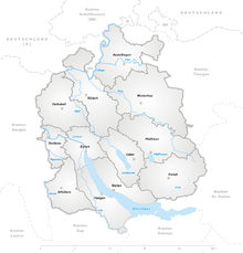
Geography

The canton of Zürich is situated in the eastern part of the Swiss plateau. It is entirely within the drainage basin of the High Rhine. It is characterized by Glacial landform and traversed by a series of rivers generally flowing south-east to north-west, listed west to east: Reuss, Reppisch, Sihl, Linth-Limmat (forming Lake Zürich), Glatt, Töss and Thur. The main lakes are the Lake Zürich (Linth-Limmat, 88 km2), Greifensee (Glatt, 8.4 km2) and Pfäffikersee (Glatt, 3.3 km2). Minor lakes include Türlersee (Limmat), Katzensee (Glatt), Hüttnersee (Sihl), Lützelsee (Limmat).
Its neighbouring cantons are Schaffhausen to the north, Aargau to the west, the cantons of Zug and Schwyz to the south and the cantons of Thurgau and St. Gallen to the east. It also borders the German districts of Waldshut and (albeit only for 460 m (1,510 ft)) Konstanz, Baden-Württemberg.
The canton can be roughly divided into the city and lake, the Unterland in the northwest, the Oberland in the southeast, the Weinland and Winterthur in the northeast, and the Knonaueramt southwest of the Albis. The Greater Zürich Area extends beyond the cantonal borders.
Zürich has an area, as of 2011, of 1,728.8 square kilometers (667.5 sq mi). Of this area, 43.4% is used for agricultural purposes, while 30.7% is forested. Of the rest of the land, 20.1% is settled (buildings or roads) and 5.8% is unproductive land.[7]
Most of the canton consists of shallow river valleys which drain towards the High Rhine to the north. Rafzerfeld is a territory north of the Rhine acquired by the canton in 1651. In the northwest and southeast of the canton the territory rises towards the Jura and Alps, respectively. The valley of the river Linth leads into the Lake Zürich and continues as the Limmat river. This valley is the most significant valley of the canton of Zürich. The valley of the Glatt river originates in the Greifensee and is separated from the Limmat by ridges. The valley of the river Töss is gorge-like. It is located in the east of the canton and is separated from the Toggenburg area in the Canton of St. Gallen by a mountainous area. The Hörnli (1133 m) is the highest elevation of this mountain ridge. The valley of the river Sihl is located in the west of the canton. In confluences with the river Limmat in the city of Zürich. The river Sihl is separated from the lake of Zürich by the Albis Range. The Albishorn (915 m (3,002 ft)) is the highest elevation of this range. The Schnebelhorn is a mountain located near Fischenthal in the Töss Valley, between the cantons of Zürich (west) and St. Gallen (east). It is the highest summit (1,292 m (4,239 ft)) of the canton of Zürich. The Uetliberg is part of the Albis Range. This mountain is popular with the population of the city of Zürich for recreation.
Coat of arms
The blazon of the coat of arms is Per bend azure and argent.[8]
Government
Legislative power
The Cantonal Council (Kantonsrat) has 180 members elected every four years.
Executive power
The canton is governed by a seven-member council (Regierungsrat). On 3 April 2011, the following were elected for four years:[9]
- Ursula Gut (FDP)
- Martin Graf (Green Party of Switzerland)
- Thomas Heiniger (FDP)
- Mario Fehr (SP)
- Regine Aeppli (SP)
- Markus Kägi (SVP)
- Ernst Stocker (SVP)
Political subdivisions
Districts
The Canton is divided into 12 districts (German: Bezirke):
- Zürich comprises the city of Zürich
- Affoltern with capital Affoltern am Albis
- Andelfingen with capital Andelfingen
- Bülach with capital Bülach
- Dielsdorf with capital Dielsdorf
- Dietikon with capital Dietikon
- Hinwil with capital Hinwil
- Horgen with capital Horgen
- Meilen with capital Meilen
- Pfäffikon with capital Pfäffikon
- Uster with capital Uster
- Winterthur with capital Winterthur
Municipalities
There are as of December 2014 169 municipalities in the canton (Politische Gemeinden).
Merger of municipalities
There were no changes between 1934 and 2013, but as of December 2014 occurred in all two merger as per 1 January 2014 and 1 January 2015.
- 2014: Bertschikon bei Attikon and Wiesendangen → Wiesendangen[10][11]
- 2015: Bauma and Sternenberg → Bauma[12][13]
Politics
In the 2011 federal election the most popular party was the SVP which received 29.8% of the vote. The next three most popular parties were the SP (19.3%), the FDP (11.6%) and the glp (11.5%).[14]
The SVP received about the same percentage of the vote as they did in the 2007 Federal election (33.9% in 2007 vs 29.8% in 2011). The SPS retained about the same popularity (19.8% in 2007), as well as the FDP (13.2% in 2007), while the glp was the big winner of the election (7.0% in 2007).[15]
Federal election results
| Percentage of the total vote per party in the canton in the Federal Elections 1971-2015[16] | ||||||||||||||
|---|---|---|---|---|---|---|---|---|---|---|---|---|---|---|
| Party | Ideology | 1971 | 1975 | 1979 | 1983 | 1987 | 1991 | 1995 | 1999 | 2003 | 2007 | 2011 | 2015 | |
| FDP.The Liberalsa | Classical liberalism | 16.8 | 18.5 | 22.4 | 21.8 | 20.3 | 18.7 | 18.1 | 17.8 | 16.2 | 13.2 | 11.6 | 15.3 | |
| CVP/PDC/PPD/PCD | Christian democracy | 9.5 | 9.4 | 9.7 | 9.1 | 7.1 | 5.9 | 4.9 | 5.1 | 5.4 | 7.6 | 5.0 | 4.2 | |
| SP/PS | Social democracy | 20.9 | 23.9 | 26.5 | 23.0 | 17.4 | 18.8 | 23.1 | 25.6 | 25.7 | 19.8 | 19.3 | 21.4 | |
| SVP/UDC | Swiss nationalism | 12.2 | 11.3 | 14.5 | 13.8 | 15.2 | 20.2 | 25.5 | 32.5 | 33.4 | 33.9 | 29.8 | 30.7 | |
| LPS/PLS | Swiss Liberal | * b | * | * | * | * | * | 0.5 | 0.2 | * | * | * | * | |
| Ring of Independents | 16.5 | 15.6 | 11.2 | 9.9 | 11.6 | 6.1 | 5.3 | 2.1 | * | * | * | * | ||
| EVP/PEV | Christian democracy | 5.2 | 5.4 | 5.7 | 5.4 | 4.4 | 4.8 | 3.7 | 3.4 | 4.1 | 3.7 | 3.1 | 3.1 | |
| CSP/PCS | Christian socialism | * | * | * | * | * | * | 0.2 | 0.2 | * | 0.1 | 0.2 | * | |
| GLP/PVL | Green liberalism | * | * | * | * | * | * | * | * | * | 7.0 | 11.5 | 8.2 | |
| BDP/PBD | Conservatism | * | * | * | * | * | * | * | * | * | * | 5.3 | 3.6 | |
| PdA/PST-POP/PC/PSL | Socialism | 1.6 | 1.1 | 1.2 | 0.3 | 0.3 | * | * | * | * | 0.2 | 0.2 | 0.2 | |
| POCH | * | 1.5 | 2.3 | 3.8 | 3.8 | e | * | * | * | * | * | * | ||
| GPS/PES | Green politics | * | * | 1.3 | 4.2 | 8.0 | 7.0 | 6.5 | 4.1 | 8.5 | 10.4 | 8.4 | 6.9 | |
| FGA | * | * | * | 0.6 | c | 2.4 | 2.7 | 1.8 | 1.4 | 1.1 | d | d | ||
| SD/DS | National conservatism | 5.0 | 4.4 | 2.5 | 5.9 | 5.0 | 5.2 | 3.3 | 1.5 | 0.9 | 0.5 | 0.3 | 0.2 | |
| Rep. | 10.4 | 6.2 | 0.9 | 0.0 | 0.5 | 0.0 | 0.0 | 0.0 | 0.0 | 0.0 | 0.0 | 0.0 | ||
| EDU/UDF | Christian right | * | 0.5 | 0.4 | 0.6 | 1.8 | 1.8 | 1.9 | 1.8 | 2.1 | 2.1 | 2.2 | 2.1 | |
| FPS/PSL | Right-wing populism | * | * | * | * | 3.8 | 5.9 | 3.5 | 0.8 | 0.1 | 0.1 | * | * | |
| Other | 2.0 | 2.2 | 1.6 | 1.5 | 0.8 | 3.3 | 0.9 | 3.0 | 2.2 | 0.3 | 3.1 | 4.2 | ||
| Voter participation % | 57.8 | 50.4 | 46.4 | 46.9 | 47.5 | 46.3 | 43.0 | 45.1 | 45.1 | 49.0 | 46.8 | 47.2 | ||
- ^a FDP before 2009, FDP.The Liberals after 2009
- ^b "*" indicates that the party was not on the ballot in this canton.
- ^c Part of a coalition with the POCH
- ^d Part of a coalition with the parties listed under Other
- ^e Party fragmented, part remained in a coalition with the FGA and the remainder joining the Green Party
Demographics
Zürich has a population (as of December 2015) of 1,463,459.[2] As of 2010, 23.7% of the population are resident foreign nationals. Over the last 10 years (2000–2010) the population has changed at a rate of 12.7%. Migration accounted for 10.3%, while births and deaths accounted for 2.6%.[7]
Most of the population (as of 2000) speaks German (1,040,168 or 83.4%) as their first language, Italian is the second most common (49,750 or 4.0%) and Serbo-Croatian is the third (21,334 or 1.7%). There are 17,685 people who speak French and 2,606 people who speak Romansh.[17]
Of the population in the canton, 314,394 or about 25.2% were born in Zürich and lived there in 2000. There were 291,631 or 23.4% who were born in the same canton, while 284,461 or 22.8% were born somewhere else in Switzerland, and 310,532 or 24.9% were born outside of Switzerland.[17]
As of 2000, children and teenagers (0–17 years old) make up 20.5% of the population, while adults (18–64 years old) make up 64.4% and seniors (over 64 years old) make up 15%.[7] As of 2000, there were 531,094 people who were single and never married in the canton. There were 566,636 married individuals, 66,012 widows or widowers and 84,164 individuals who are divorced.[17]
As of 2000, there were 567,573 private households in the canton, and an average of 2.1 persons per household.[7] There were 223,869 households that consist of only one person and 27,935 households with five or more people. As of 2009, the construction rate of new housing units was 5.3 new units per 1000 residents.[7] As of 2003 the average price to rent an average apartment in the city of Zürich was 1288.84 Swiss francs (CHF) per month (US$1030, £580, €820 approx. exchange rate from 2003). The average rate for a one-room apartment was 733.01 CHF (US$590, £330, €470), a two-room apartment was about 1009.94 CHF (US$810, £450, €650), a three-room apartment was about 1192.66 CHF (US$950, £540, €760) and a six or more room apartment cost an average of 2550.35 CHF (US$2040, £1150, €1630). The average apartment price in the city of Zürich was 115.5% of the national average of 1116 CHF.[18]
The vacancy rate for the canton, in 2010, was 0.63%.[7]
Historical population
The historical population is given in the following chart:[19]

Religion
In 1519, Huldrych Zwingli became the pastor of the Grossmünster in Zürich, and soon thereafter Zürich became a reformed or Protestant canton. Even though Zwingli died in battle in 1531, the canton remained a stronghold of the Swiss Reformed Church over the following centuries. While a plurality of the population is Protestant (43%), 31% of the population was Roman Catholic in 2004,[20] a legacy of considerable immigration from Southern Europe.
From the 2000 census, 497,986 or 39.9% belonged to the Swiss Reformed Church, while 380,440 or 30.5% were Roman Catholic. Of the rest of the population, there were 29,592 members of an Orthodox church (or about 2.37% of the population), there were 1,435 individuals (or about 0.11% of the population) who belonged to the Christian Catholic Church, and there were 70,897 individuals (or about 5.68% of the population) who belonged to another Christian church. There were 6,461 individuals (or about 0.52% of the population) who were Jewish, and 66,520 (or about 5.33% of the population) who were Islamic. There were 5,878 individuals who were Buddhist, 6,024 individuals who were Hindu and 1,456 individuals who belonged to another church. 165,324 (or about 13.25% of the population) belonged to no church, are agnostic or atheist, and 50,090 individuals (or about 4.01% of the population) did not answer the question.[17]
Economy
Most of the land is cultivated, but the canton of Zürich is not considered as an agricultural area. The lands to the north and east are more agricultural, but in every part of the canton manufacturing predominates. The canton of Zürich is noted for machinery. Silk and cotton weaving were important in the past, but have now ceased to be of importance. There is a large paper industry. Small and middle sized companies are important contributors to the economy of the canton of Zürich. The city of Zürich is a major banking centre, and insurance is also of importance.
As of 2010, Zürich had an unemployment rate of 3.9%. As of 2008, there were 12,507 people employed in the primary economic sector and about 4,227 businesses involved in this sector. 143,231 people were employed in the secondary sector and there were 11,383 businesses in this sector. 655,848 people were employed in the tertiary sector, with 58,796 businesses in this sector.[7]
In 2008 the total number of full-time equivalent jobs was 678,306. The number of jobs in the primary sector was 8,120, of which 7,771 were in agriculture, 320 were in forestry or lumber production and 29 were in fishing or fisheries. The number of jobs in the secondary sector was 133,723 of which 81,212 or (60.7%) were in manufacturing, 774 or (0.6%) were in mining and 47,014 (35.2%) were in construction.
The number of jobs in the tertiary sector was 536,463. In the tertiary sector; 105,226 or 19.6% were in the sale or repair of motor vehicles, 38,005 or 7.1% were in the movement and storage of goods, 33,417 or 6.2% were in a hotel or restaurant, 35,571 or 6.6% were in the information industry, 81,163 or 15.1% were the insurance or financial industry, 65,139 or 12.1% were technical professionals or scientists, 36,792 or 6.9% were in education and 63,800 or 11.9% were in health care.[21]
Of the working population, 37.4% used public transportation to get to work, and 41.8% used a private car.[7]
Transport
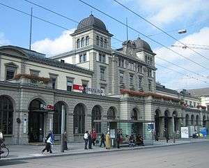
Railways in standard gauge run through all major valleys in the canton. The centre for transport is Zürich, where a great number of local railways connect to national and international rail links. The railway station of the city of Zürich, Zürich Hauptbahnhof, is one of the busiest in Europe, counting the number of arriving and departing trains. Zürich is well connected to other European cities using rail links. The major trains ICE, TGV and Cisalpino connect to Zürich.
The first Swiss railway ran in the Limmat valley in 1847, connecting Zürich to Baden.
The major airport of Switzerland Zürich Airport is located in Zürich-Kloten, a mere 12 kilometres (7.5 miles) from the city centre of Zürich. It is home to Swiss International Air Lines.
The A1, A3 and A4 motorways run through the canton. Other motorways and expressways which also run through the canton include the A7, the A51, the A52 and the A53. Major hubs are Zürich and Winterthur.
Education
In Zürich about 493,209 or (39.5%) of the population have completed non-mandatory upper secondary education, and 212,154 or (17.0%) have completed additional higher education (either university or a Fachhochschule). Of the 212,154 who completed tertiary schooling, 55.8% were Swiss men, 25.5% were Swiss women, 11.6% were non-Swiss men and 7.1% were non-Swiss women.[17]
Notes and references
- ↑ Arealstatistik Standard - Kantonsdaten nach 4 Hauptbereichen
- 1 2 3 Canton of Zurich Statistical Office (German) accessed 27 April 2016
- ↑ "Prehistoric Pile Dwellings in Switzerland". Swiss Coordination Group UNESCO Palafittes (palafittes.org). Retrieved 2014-12-07.
- ↑ "World Heritage". palafittes.org. Retrieved 2014-12-10.
- ↑ "A-Objekte KGS-Inventar". Schweizerische Eidgenossenschaft, Amt für Bevölkerungsschutz. 2009. Archived from the original on 28 June 2010. Retrieved 2014-12-10.
- ↑ Christoph Ebnöther (2010-09-28). "Polizei" (in German). HDS. Retrieved 2015-01-17.
- 1 2 3 4 5 6 7 8 Swiss Federal Statistical Office accessed 5 January 2012
- ↑ Flags of the World.com accessed 5 January 2012
- ↑ "Klare bürgerliche Mehrheit im Regierungsrat" , Neue Zürcher Zeitung, April 16, 2007.
- ↑ Bertschikon and Wiesendangen merged to Wiesendangen on 1 January 2014.
- ↑ "Bertschikon" (in German). Zürcher Oberländer. Retrieved 2015-01-03.
- ↑ Bauma and Sternenberg merged to Bauma on 1 January 2015.
- ↑ "Dossier Sternenberg" (in German). Zürcher Oberländer. Retrieved 2015-01-03.
- ↑ Swiss Federal Statistical Office, Elections in Switzerland (German) accessed 5 January 2012
- ↑ Swiss Federal Statistical Office, Nationalratswahlen 2007: Stärke der Parteien und Wahlbeteiligung, nach Gemeinden/Bezirk/Canton Archived 14 May 2015 at the Wayback Machine. (German) accessed 28 May 2010
- ↑ Nationalratswahlen: Stärke der Parteien nach Kantonen (Schweiz = 100%) (Report). Swiss Federal Statistical Office. 2015.
- 1 2 3 4 5 STAT-TAB Datenwürfel für Thema 40.3 - 2000 Archived 9 April 2014 at the Wayback Machine. (German) accessed 2 February 2011
- ↑ Swiss Federal Statistical Office-Rental prices 2003 data (German) accessed 26 May 2010
- ↑ Swiss Federal Statistical Office STAT-TAB Bevölkerungsentwicklung nach Region, 1850-2000 Archived 30 September 2014 at the Wayback Machine. (German) accessed 29 January 2011
- ↑ Federal Department of Statistics (2004). "Wohnbevölkerung nach Religion" (Interactive Map). Retrieved 2009-01-15.
- ↑ Swiss Federal Statistical Office STAT-TAB Betriebszählung: Arbeitsstätten nach Gemeinde und NOGA 2008 (Abschnitte), Sektoren 1-3 Archived 25 December 2014 at the Wayback Machine. (German) accessed 28 January 2011
External links
| Wikimedia Commons has media related to Canton of Zürich. |
| ||||||||
| ||||||||
| Settlements | 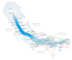 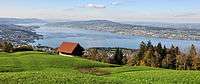 | |
|---|---|---|
| Islands | ||
| Rivers | ||
| Valleys | ||
| Mountains | ||
| Landmarks | ||
| Transportation |
| |
| People | ||