Ōtsuki, Yamanashi
| Ōtsuki 大月市 | |||
|---|---|---|---|
| City | |||
|
Ōtsuki City Hall | |||
| |||
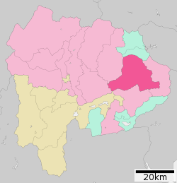 Location of Ōtsuki in Yamanashi Prefecture | |||
 Ōtsuki
| |||
| Coordinates: 35°36′38″N 138°56′24″E / 35.61056°N 138.94000°ECoordinates: 35°36′38″N 138°56′24″E / 35.61056°N 138.94000°E | |||
| Country | Japan | ||
| Region | Chūbu | ||
| Prefecture | Yamanashi Prefecture | ||
| Area | |||
| • Total | 280.25 km2 (108.21 sq mi) | ||
| Population (November 1, 2015) | |||
| • Total | 25,352 | ||
| • Density | 90.5/km2 (234/sq mi) | ||
| Time zone | Japan Standard Time (UTC+9) | ||
| - Tree | Yaezakura (Prunus lannesiana) | ||
| - Flower | Lilium auratum | ||
| Phone number | 0554-22-2111 | ||
| Address | 2-6-20 Ōtsuki, Ōtsuki-shi, Yamanashi-ken 401-8601 | ||
| Website |
www | ||


Ōtsuki (大月市 Ōtsuki-shi) is a city located in eastern Yamanashi Prefecture, Japan.
As of November 2015, the city had an estimated population of 25,252 and a population density of 90.5 persons per km². The total area was 380.25 square kilometres (146.82 sq mi).
Geography
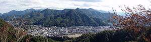
Ōtsuki is located in eastern Yamanashi Prefecture, approximately 80 kilometers from Tokyo.
Surrounding municipalities
Yamanashi Prefecture
History
Located in the headwaters of the Sagami River, the area around present-day Ōtsuki was heavily settled in the Jōmon period, and over 80 Jōmon sites have been found within city limits. However, there are fewer Yayoi period sites. During the Nara period ritsuryo organization of Kai Province, the area came under Tsuru County. From the middle of the Kamakura period, much of the province came under the control of the Takeda clan.
During the Edo period, all of Kai Province was tenryō territory under direct control of the Tokugawa shogunate, although the portion around modern day Ōtsuki was part of the short-lived Tamimura Domain, which was suppressed in 1704. Also during the Edo period, the Kōshū Kaidō, one of the Edo Five Routes, passed through Ōtsuki, which with 12 of the 45 post stations has more post stations than any other municipality in Japan. The eleven post stations spread from Shimotorisawa-shuku to Kuronoda-shuku.
During the cadastral reform of the early Meiji period in July 1, 1889, the village of Hirosato was created within Kitatsuru District, Yamanashi Prefecture. On April 1, 1933 the village was raised to town status, and renamed Ōtsuki. The town was bombed by the United States on August 13, 1945, only two days before the end of World War II. The town was elevated to city status on August 8, 1954.
Education
- Ohtsuki City College
- Ōtsuki has eight elementary schools, four middle schools and two high schools.
Transportation
Railway
Highway
Sister city relations
 Fraser Coast, Queensland, Australia [1]
Local attractions
- Saruhashi - A famous historical bridge. ja:猿橋
- Yatsuzawa Power Station
Noted people
- Masanori Murakami – former professional baseball player
- Masahide Kobayashi – former professional baseball player
References
- ↑ "International Exchange". List of Affiliation Partners within Prefectures. Council of Local Authorities for International Relations (CLAIR). Retrieved 21 November 2015.
External links
| Wikimedia Commons has media related to Ōtsuki, Yamanashi. |
| Wikivoyage has a travel guide for Otsuki. |
- Official website (Japanese)
| Special city | ||
|---|---|---|
| Cities | ||
| Kitatsuru District | ||
| Minamikoma District | ||
| Minamitsuru District | ||
| Nakakoma District | ||
| Nishiyatsushiro District | ||