162nd meridian east

162°
162nd meridian east

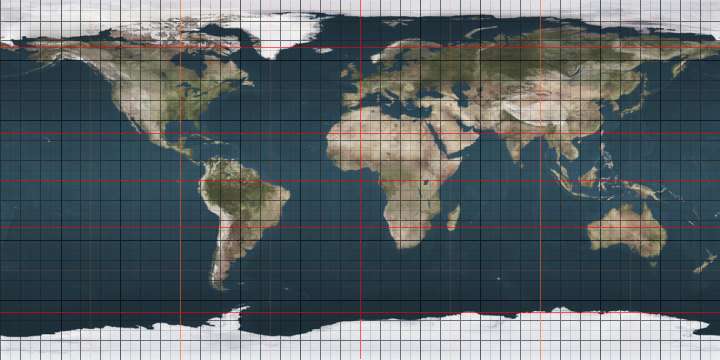
The meridian 162° east of Greenwich is a line of longitude that extends from the North Pole across the Arctic Ocean, Asia, the Pacific Ocean, the Southern Ocean, and Antarctica to the South Pole.

The 162nd meridian east forms a great circle with the 18th meridian west.

From Pole to Pole

Starting at the North Pole and heading south to the South Pole, the 162nd meridian east passes through:

Co-ordinates Country, territory or sea Notes
90°0′N 162°0′E / 90.000°N 162.000°E / 90.000; 162.000 (Arctic Ocean) Arctic Ocean
75°51′N 162°0′E / 75.850°N 162.000°E / 75.850; 162.000 (East Siberian Sea) East Siberian Sea Passing between the Medvyezhi Islands, Sakha Republic,  Russia (at 70°40′N 162°0′E / 70.667°N 162.000°E / 70.667; 162.000 (Medvyezhi Islands))
69°33′N 162°0′E / 69.550°N 162.000°E / 69.550; 162.000 (Russia)  Russia Sakha Republic
Chukotka Autonomous Okrug — from 68°21′N 162°0′E / 68.350°N 162.000°E / 68.350; 162.000 (Chukotka Autonomous Okrug)
Magadan Oblast — from 64°48′N 162°0′E / 64.800°N 162.000°E / 64.800; 162.000 (Magadan Oblast)
61°22′N 162°0′E / 61.367°N 162.000°E / 61.367; 162.000 (Sea of Okhotsk) Sea of Okhotsk Penzhin Bay
60°26′N 162°0′E / 60.433°N 162.000°E / 60.433; 162.000 (Russia)  Russia Kamchatka KraiKamchatka Peninsula
55°55′N 162°0′E / 55.917°N 162.000°E / 55.917; 162.000 (Pacific Ocean) Pacific Ocean
54°58′N 162°0′E / 54.967°N 162.000°E / 54.967; 162.000 (Russia)  Russia Kamchatka KraiKamchatka Peninsula
54°42′N 162°0′E / 54.700°N 162.000°E / 54.700; 162.000 (Pacific Ocean) Pacific Ocean Passing just west of Enewetak atoll,  Marshall Islands (at 11°30′N 162°5′E / 11.500°N 162.083°E / 11.500; 162.083 (Enewetak))
Passing just east of the island of Ulawa,  Solomon Islands (at 9°42′S 161°59′E / 9.700°S 161.983°E / -9.700; 161.983 (Ulawa))
Passing just east of the island of Malaupaina,  Solomon Islands (at 10°14′S 161°59′E / 10.233°S 161.983°E / -10.233; 161.983 (Malaupaina))
10°29′S 162°0′E / 10.483°S 162.000°E / -10.483; 162.000 (Solomon Islands)  Solomon Islands Island of Makira
10°48′S 162°0′E / 10.800°S 162.000°E / -10.800; 162.000 (Coral Sea) Coral Sea
27°28′S 162°0′E / 27.467°S 162.000°E / -27.467; 162.000 (Pacific Ocean) Pacific Ocean
60°0′S 162°0′E / 60.000°S 162.000°E / -60.000; 162.000 (Pacific Ocean) Southern Ocean Passing just west of Young Island, Balleny Islands, claimed by  New Zealand (at 66°20′S 162°7′E / 66.333°S 162.117°E / -66.333; 162.117 (Malaupaina))
70°23′S 162°0′E / 70.383°S 162.000°E / -70.383; 162.000 (Antarctica) Antarctica Ross Dependency, claimed by  New Zealand

See also

This article is issued from Wikipedia - version of the 12/21/2014. The text is available under the Creative Commons Attribution/Share Alike but additional terms may apply for the media files.