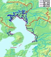
1792 Unzen earthquake and tsunami
  | |
| Date | May 21, 1792 |
|---|---|
| Magnitude | 6.4 Ms[1] |
| Epicenter | 32°48′N 130°18′E / 32.8°N 130.3°ECoordinates: 32°48′N 130°18′E / 32.8°N 130.3°E |
| Areas affected | Japan: Kyushu, Shimabara, Nagasaki |
| Tsunami | Yes |
| Casualties | 15,000 deaths from landslide and tsunami |
The 1792 Unzen earthquake and tsunami resulted from the volcanic activities of Mount Unzen (in the Shimabara Peninsula of Nagasaki Prefecture, Japan) on 21 May. This caused the collapse of the southern flank of the Mayuyama dome in front of Mount Unzen, resulting in a tremendous tsunami, killing 15,000 people altogether. It was also called, Shimabara erupted, Higo affected (島原大変肥後迷惑), (Shimabara means the central mountain of the Shimabara Peninsula) since many people were killed by this tsunami in Higo (Kumamoto Prefecture, situated 20 km away across the Ariake Sea).
Volcanic activities
Towards the end of 1791, a series of earthquakes occurred on the western flank of Mount Unzen which gradually moved towards Fugen-dake (one of the Mount Unzen's peaks). In February 1792, Fugen-dake started to erupt, triggering a lava flow which continued for two months. Meanwhile, the earthquakes continued, shifting nearer to the city of Shimabara. On the night of 21 May, two large earthquakes were followed by a collapse of the eastern flank of Mount Unzen's Mayuyama dome, causing a landslide which swept through the city of Shimabara and into Ariake Bay, triggering a great tsunami.
-
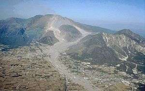
Mount Unzen (center) and Mayuyama (right) showing the destruction, recent photo
-
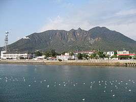
Mayuyama of Shimabara Peninsula, from the sea of Shimabara City
Tsunami
It is not known to this day whether the collapse occurred as a result of an eruption of the dome or as a result of the earthquakes. The tsunami struck Higo Province on the other side of Ariake Bay before bouncing back and hitting Shimabara again. Out of an estimated total of 15,000 fatalities, around 5,000 are thought to have been killed by the landslide, around 5,000 by the tsunami across the bay in Higo Province, and a further 5,000 by the tsunami returning to strike Shimabara. The waves reached a height of 33–66 ft (10–20 m), classing this tsunami as a small megatsunami. At the Osaki-bana point Futsu town, the waves locally grew to a height of 187 ft (57m) due to the effect of sea bottom topography.
Monuments
As of July, 1991, the following monuments have been found.[2]
| Kind of Monument | Kumamoto Prefecture | Nagasaki Prefecture | Total |
|---|---|---|---|
| Memorial monument | 43 | 41 | 84 |
| Tsunami border monument | 5 | 0 | 5 |
| Graves | 16 | 90 | 106 |
| Simple monument | 1 | 0 | 1 |
| Others | 9 | 3 | 12 |
| Total | 74 | 134 | 208 |
Lake Shirachi
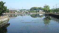
Lake Shirachi is a pond in Shimabara city, Nagasaki Prefecture which was created after the landslide at Mayuyama created by the inpouring of underground water. Its size was first 1 km (south-north) and 300m 400m (east to west), but the production of a water exit river made it smaller and it is now 200 m by 70 m.
Tsukumojima (99 Islets)
As a result of the destruction, Tsukumojima or 99 islets or rocks were distributed near Shimabara city. In the same Nagasaki Prefecture, there are 99 islands or Kujūkushima distributed from Sasebo city to Hirado city. These islands are different from Tsukumojima.
See also
References
- ↑ National Geophysical Data Center. "Comments for the Significant Earthquake". Retrieved 22 July 2011.
- ↑ 200 Years after the Kansei Great Tsunami, Symposium and Exhibition of Unzen Disaster Booklet published by Newspaper Museum, Yoyasu Machi, Kumamoto-shi, 1991