1813 crossing of the Blue Mountains
|
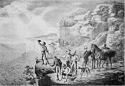
Earliest pictorial representation of the crossing from the Sydney Mail, 25 December 1880 | |
| Duration | 27 days |
|---|---|
| Date | 11 May 1813 – 6 June 1813[1] |
| Location | Blaxland's Farm - Blue Mountains - Mt Blaxland |
| Organised by | Gregory Blaxland |
| Participants | |
| Awards | Land Grants |
The 1813 crossing of the Blue Mountains was the expedition led by Gregory Blaxland, William Lawson and William Charles Wentworth, which became the first successful crossing of the Blue Mountains in New South Wales by European settlers.[2] The crossing enabled the settlers to access and use the land west of the mountains for farming, and made possible the establishment of Australia's first inland settlement at Bathurst.[3]
Background
The European settlement at Sydney Cove, established in 1788 after the arrival of the First Fleet, grew rapidly.[4] By the early 19th century, the Blue Mountains had become a barrier to the expansion of the colony, which required more farming land to meet its needs, particularly after the droughts of 1812 and 1813.[4][5][6] The local Indigenous people knew at least two routes by which to cross the mountains.[7] The first was along Bilpin Ridge, later followed by Archibald Bell with the assistance of the local Darug people (now the location of Bells Line of Road),[8] and the second was along Coxs River.[9] Until 1813 however, the settlers remained unaware of how to cross the mountains despite several attempts, including two by Blaxland himself.[4][10] Early in 1813 Blaxland, who wanted more grazing land, obtained the approval of Governor Lachlan Macquarie and approached Lawson and Wentworth to secure their participation in a new exploratory expedition following the mountain ridges.[4][11][12]
The crossing
On Tuesday, May 11, 1813, Mr. Gregory Blaxland, Mr. William Wentworth, and Lieutenant Lawson, attended by four servants, with five dogs, and four horses laden with provisions, ammunition, and other necessities, left Mr. Blaxland's farm at South Creek, for the purpose of endeavouring to effect a passage over the Blue Mountains, between the Western River, and the River Grose.
Gregory Blaxland[10]

Blaxland, Wentworth and Lawson led an expedition party, which included four servants, four pack horses and five dogs.[5] Two of the four men who assisted the party have been identified as James Burne (or Burnes), a guide and kangaroo hunter, and Samuel Fairs, a convict who arrived in Australia in 1810. The two others, also thought to be convicts, remain unidentified.[13]
The party left from Blaxland's South Creek farm[14] near the modern suburb of St Marys in western Sydney, on 11 May 1813 and crossed the Nepean River later that day.[15] They made their way over the mountains, following the ridges, and completed the crossing in 21 days.[15] The explorers' success has been attributed to their methodical approach[6] and decision to travel on the ridges instead of through the valleys.[12] The three explorers and two of their servants would set out each day, leaving the other two men at their campsite, and mark out a trail, before turning back later in the day to cut a path for the horses and allow the rest of the party to progress.[6]
The party first saw the plains beyond the mountains from Mount York.[12] They continued on to Mount Blaxland 25 km south of the site of Lithgow, on the western side of the mountains.[6] From this point Blaxland declared there was enough forest or grassland "to support the stock of the colony for thirty years",[10] while Lawson called it "the best watered Country of any I have seen in the Colony".[1] The party then turned back, making the return journey in six days.[6]
-
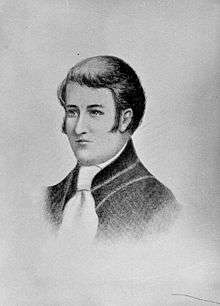
Gregory Blaxland
-
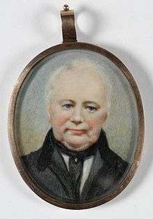
William Lawson
-
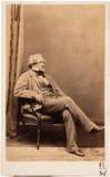
William Charles Wentworth
Journals
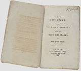
All three explorers wrote an account of their expedition. Blaxland was the only one to publish his account, Journal of a Tour of Discovery Across the Blue Mountains, which he did in 1823 during a return visit to England.[12] His journal, written in the third person, records their progress in detail, including their reasons for believing they had achieved their goals and deciding to turn back:
They now conceived that they had sufficiently accomplished the design of their undertaking, having surmounted all the difficulties which had prevented hitherto the interior of the country from being explored, and the colony from being extended. ... Their provisions were nearly expended, their clothes and shoes were in very bad condition, and the whole party were ill with bowel complaints. These considerations determine them, therefore, to return home.
Gregory Blaxland[10]
Wentworth's journal indicates his inspired impressions of the landscape:
A country of so singular a description could in my opinion only have been produced by some Mighty convulsion in Nature – Those immense unconnected perpendicular Masses of Mountain which are to be seen towards its Eastern Extremity towering above the Country around, seem to indicate that the whole of this tract has been formed out of the Materials of the primitive mountains of which these masses are the only parts that have withstood the violence of the concussion.
William Wentworth[16]
Lawson, as a trained surveyor,[17] kept detailed notes about the route itself including the distances covered each day, as well as his impressions of the landscape. He recorded on 22 May:
Reached the summit of the Highest land we have yet been, ... and Encamped by a fine stream of water. Here we had a fine view of all our Settlements, our progress was here stoped by an impassable Clift from going either South or West- Mr. Blaxland Wentworth and Self left our Camp with a determination to get down some parts of this broken land. But found it impracticable in some places 500 feet perpendicular here we saw the course of the Western River and that broken Country at Natai the back of the Cow pasters. No doubt this is the Remnant of some dreadful Earthquake
William Lawson, 22 May 1813[1]
-
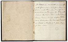
Blaxland's journal
-
Lawson's journal
-

Wentworth's journal
Afterwards
In recognition of the successful crossing, all three explorers were rewarded by Macquarie with a grant of 1000 acres of land west of the mountains.[17][18] Blaxland later claimed to have led the expedition, however records from the time of the crossing imply that they were joint leaders.[12]
Surveyor-General George William Evans was dispatched by Macquarie in November 1813 to follow the path taken and travel further to determine the best route to access the arable farmland.[19] Evans continued past Mount Blaxland to the Macquarie and Lachlan Rivers and the site of modern Bathurst.[19] Upon his return, he was rewarded with 1000 acres of land in Tasmania.[20] Macquarie then commissioned William Cox in July 1814 to construct a road, following the path taken by the three explorers and extended by Evans.[21] Cox's team of convict workers completed the job in six months and Cox was rewarded by Macquarie with a grant of 2000 acres of land near the site chosen by Macquarie for Bathurst.[21][22] Macquarie travelled along the new road, naming it the Great Western Road, in 1815.[19] Artist John Lewin accompanied Macquarie on the tour.[23]
The colonial expansion into the lands of the Wiradjui nation, west of the Blue Mountains, led to the Bathurst war.
-
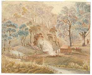
Watercolour painting of Campbells River, by John Lewin (1815)
-
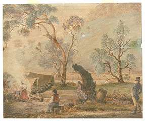
Watercolour painting of Cox's Pass, by John Lewin (1815)
Commemorations
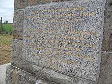
_Blaxland_Lawson_Wentworth_Memorial.JPG)
The crossing and the three explorers have been commemorated in a number of ways, including:
- Several memorials to the explorers have been erected along the route they followed.
- Events to mark the centenary included a luncheon at Mount Victoria.[24]
- Frank Walker, then President of the Royal Australian Historical Society,[25] published a compilation of articles about the crossing and photographs of the Blue Mountains in time for the centenary[26]
- Three suburbs in the Blue Mountains are named after the explorers: Blaxland, Lawson, and Wentworth Falls.
- Three Federal electorates were named after the explorers: Division of Blaxland, Division of Lawson (abolished in 1968), and Division of Wentworth.
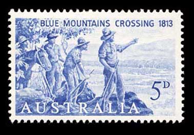
- For the 150th anniversary, a 1963 postage stamp featured an image of the expedition.[27]
- Events to mark the bicentenary in 2013 included the Blue Mountains Blue Wave walking party following the route taken by the expedition,[28] a flyover involving 70 aircraft,[29] a silver coin issued by the Royal Australian Mint,[30] and performances of a play written by a descendant of Blaxland.[31]
It has been claimed that Blaxland, Wentworth and Lawson may have carved their initials into the tree now referred to as the Explorers tree, located about 5 kilometres west of Katoomba.[32] This claim is not universally supported[33] and the tree is not specifically mentioned in the journals kept by the explorers, although they did mark trees to record their route.[34]
Locations
- South Creek Farm – 33°48′21″S 150°45′56″E / 33.805847°S 150.765587°E
- Caley's Repulse 33°43′05″S 150°29′42″E / 33.71795°S 150.49513°E
- Mount York – 33°33′12″S 150°13′11″E / 33.5533°S 150.21966°E
- Mount Blaxland – 33°32′51″S 150°06′20″E / 33.54750°S 150.10556°E
- Wentworth's Sugarloaf – 33°32′33″S 150°06′30″E / 33.54250°S 150.10833°E
- Lawson's Sugarloaf – 33°32′27″S 150°06′36″E / 33.54083°S 150.11000°E
See also
References
- 1 2 3 Lawson, William (1774-1850). "Lawson's journal". State Library of NSW. Retrieved 28 May 2013.
- ↑ "Lawson, William". Dictionary of Sydney. Retrieved 27 May 2013.
- ↑ "History – general history". Blue Mountains Crossings Bicentenary. Retrieved 28 May 2013.
- 1 2 3 4 "History since colonisation". Blue Mountains National Park. NSW Parks and Wildlife Service. Retrieved 27 May 2013.
- 1 2 "History in Detail". Blue Mountains Australia. Retrieved 27 May 2013.
- 1 2 3 4 5 "Crossing the Blue Mountains". Discover Collections. State Library of NSW. Retrieved 27 May 2013.
- ↑ "Myths and Mysteries of the crossing of the Blue Mountains (pdf)" (PDF). National Museum of Australia. Retrieved 29 May 2013.
- ↑ "Hawkesbury Valley". Greater Blue Mountains Drive. Retrieved 29 May 2013.
- ↑ "The Arms Chronicle". The Arms of Australia Inn Museum. Retrieved 29 May 2013.
- 1 2 3 4 Blaxland, Gregory (1778-1853); Walker, Frank (2002), A journal of a tour of discovery across the Blue mountains, New South Wales, in the year 1813, The University of Adelaide Library, retrieved 18 May 2016
- ↑ A History of Australia, Vol. 1, C.M.H.Clark (Melbourne University Press) 1962, p. 277
- 1 2 3 4 5 "Gregory Blaxland". Australian Dictionary of Biography. Retrieved 27 May 2013.
- ↑ Cunningham-Lewis, Brenda (10 April 2013). "Research 'hunch' reveals identity of convict from Blue Mountains crossing By t". Blue Mountains Gazette. Retrieved 27 May 2013.
- ↑ "History – the three explorers". Blue Mountains crossing bicentenary. Archived from the original on 23 March 2014. Retrieved 27 May 2013.
- 1 2 Flannery, Tim (2010). The Explorers. Melbourne: The Text Publishing House. ISBN 9781876485221.
- ↑ Wentworth, Charles (1790-1872). Wentworth's journal. Discover Collections. State Library of NSW.
- 1 2 "William Lawson". Australian Dictionary of Biography. Retrieved 27 May 2013.
- ↑ Crossing of the Blue mountains, Boardman (Scholastic Australia) 1997, pp.29–30
- 1 2 3 "Macquarie's crossing". Discover Collections. State Library of NSW. Retrieved 27 May 2013.
- ↑ "George William Evans". Australian Dictionary of Biography. Retrieved 28 May 2013.
- 1 2 "William Cox". Australian Dictionary of Biography. Retrieved 28 May 2013.
- ↑ Cox, William (1888), A narrative of proceedings of William Cox, Esq., of Clarendon, lately holding a commission in the New South Wales Corps or 102nd Regiment, in constructing a road from Capt. Woodriffe's farm on the Nepean River, opposite Emu Plains, over the Blue Mountains, and from thence to Bathurst Plains, on the banks of the Macquarie River, in the years 1814 & 1815, s.n.], retrieved 11 May 2016
- ↑ "John William Lewin". Australian Dictionary of Biography. Retrieved 30 May 2013.
- ↑ "CROSSING THE BLUE MOUNTAINS.". Singleton Argus (NSW : 1880 - 1954) . NSW: National Library of Australia. 31 May 1913. p. 1. Retrieved 31 May 2013.
- ↑ "Frank Walker Crossings". Royal Australian Historical Society. Retrieved 11 July 2013.
- ↑ "The first crossing of the Blue Mountains : [newspaper extracts, manuscript notes, maps, photographs, etc.] / illustrated by Frank Walker.". SLNSW Catalogue. State Library of NSW. Retrieved 11 July 2013.
- ↑ "First Crossing of Blue Mountains, 150 years". Australian Stamp. Retrieved 28 May 2013.
- ↑ "Heading west: trip taps pioneer spirit". Sydney Morning Herald. 2013-03-26. Retrieved 27 May 2013.
- ↑ "Flyover Magic". St Marys-Mount Druitt Star. Fairfax Regional Media. Retrieved 27 May 2013.
- ↑ "First Crossing of Blue Mountains, 200 years". Allnumis News. Retrieved 31 May 2013.
- ↑ Ashworth, Len (11 May 2013). "Descendant launches her play on explorers' crossing". The Lithgow Mercury. Fairfax Regional Media. Retrieved 31 May 2013.
- ↑ "Katoomba". Blue Mountains Australia. Retrieved 28 May 2013.
- ↑ "Explorers Tree". Blue Mountains City Council. Retrieved 28 May 2013.
- ↑ Low, John. "The Marked Explorer's Tree". Six Foot Track Marathon. Retrieved 28 May 2013.
External links
- Blaxland's journal - record at the State Library of NSW
- Blaxland's journal images of published journal (1870) - at the State Library of NSW
- Blaxland's journal (digitised) at the University of Sydney
- Blaxland's journal (digitised) at the University of Adelaide
- Lawson's journal (original) (digitised) at the State Library of NSW
- Lawson's journal (html)(digitised) at Gutenberg
- Wentworth's journal (digitised) at the State Library of NSW
- Journal of Gregory Blaxland, edited by Frank Walker in 1913 at Project Gutenberg Australia
- Blue Mountains Blue Wave "Celebration of Mountain Life" 200th Bicentenary celebrations
- Blue Mountains Local History blog