Mount Victoria, New South Wales
| Mount Victoria New South Wales | |||||||||||||
|---|---|---|---|---|---|---|---|---|---|---|---|---|---|
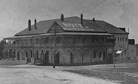 Mount Victoria Hotel in the 1920s | |||||||||||||
|
Mount Victoria | |||||||||||||
| Coordinates | 33°35′S 150°15′E / 33.583°S 150.250°ECoordinates: 33°35′S 150°15′E / 33.583°S 150.250°E | ||||||||||||
| Population | 823 (2011 census)[1] | ||||||||||||
| Established | 1866[2] | ||||||||||||
| Postcode(s) | 2786 | ||||||||||||
| Elevation | 1,052 m (3,451 ft)[3] | ||||||||||||
| Location |
| ||||||||||||
| LGA(s) | City of Blue Mountains[4] | ||||||||||||
| County | Cook[4] | ||||||||||||
| Parish | Hartley[4] | ||||||||||||
| State electorate(s) | Blue Mountains[5] | ||||||||||||
| Federal Division(s) | Macquarie[6] | ||||||||||||
| |||||||||||||
| |||||||||||||
Mount Victoria (postcode: 2786) is a small township in the Blue Mountains of New South Wales, Australia. It is the westernmost village in the City of Blue Mountains, located about 120 kilometres (75 mi) by road from the Sydney central business district and at an altitude of about 1,052 metres (3,451 ft) AHD .[8] The settlement had a population of 823 people at the 2011 Census.[1]
History
.jpg)
Mount Victoria is located on an escarpment plateau extension of Mount York, the site of a camp on the original Blaxland, Wentworth and Lawson crossing of the Blue Mountains in 1813. The area was originally marked as One Tree Hill on an early map dating from 1834 by the Surveyor General, Sir Thomas Mitchell.[8] This is why when the township was established in 1866 it was known as One Tree Hill.[2]
After the road across the Blue Mountains was constructed a toll bar was opened about 1 kilometre (0.62 mi) east from the present township in 1849 and the area was also known as Broughton's Waterhole Toll Bar.[9] Coaches were charged at the toll according to how well sprung they were, ones without springs were not charged as it was believed they would help crush the road surface.[8]
After the railway station, marking the termination of the Main Western railway line, was opened in 1869 the town also became known as Mount Victoria.[9][10] The town's name was officially changed after the first Post Office was built in 1876.[8]
By the late 19th century, the town had become a prosperous settlement and many private schools, including The School, Mount Victoria, were founded in the area, which become somewhat of a hill station retreat for wealthy Sydney families.[8]
Asgard Swamp Coal Mine
Asgard_Swamp_coal_mine-2.jpg)
To the south-east of Mount Victoria lies the Asgard Swamp area, now part of the Blue Mountains National Park. The area is the site of a coal mine that was developed in the nineteenth century, but which was ultimately unsuccessful. Six adits were driven into the coal seam by Walter Mackenzie and Thomas Garret, circa 1881. A coke oven was built and it was also proposed to build a tramline from Mount Victoria, but it is not known if this ever happened. The leases changed hands a few times over the years, but no work was done after 1908.[11] Around the south and east edges of Asgard Swamp, there are the remains of huts used by the people who worked the mines.
Mount Victoria Cemetery
Mount_Victoria_Cemetery-1.jpg)
Mount Victoria Cemetery, located one and a half kilometres south-east of the township, was established in 1881. Notable internees include John Berghofer, the builder of Berghofer's Pass at Mount York. (The pass, no longer used for vehicular traffic, has since been included in a network of walking tracks at Mount York. The Mount York area is now heritage-listed.)[12]
Other internees include members of the Lanfranchi family, owners of Marthaville, a heritage-listed house on the Great Western Highway.[13]
Present day
Today, Mount Victoria is a small township with a large number of historic buildings and a few attractions including the Post Office, a Hall which is used as a cinema, the Imperial Hotel, the Toll Keepers Cottage and a museum at the railway station.[8]
The town is the starting point for many bushwalks and features several lookouts over the Kanimbla Valley including the lookout from Mount Piddington.[8]
The railway station, along with Lithgow, is the terminus for the Blue Mountains Line. The town is located at the junction of the Great Western Highway and the Darling Causeway to Bell. The Roads and Maritime Services is at present researching a major upgrade to the Great Western Highway with the view to bypass the township and the steep Victoria Pass down to Little Hartley to the west.[14]
Heritage Buildings
Mount Victoria contains a number of buildings with historic significance.
- Imperial Hotel: The Imperial Hotel was constructed in 1878 and is significant for being the only hotel in the Blue Mountains to trade continuously under its own name.[15]
- St Peter's Anglican Church: Designed by architect David Macbeath and built of sandstone in 1874-1875 by contractor Alexander Armstrong, this is the oldest Christian Church in the Blue Mountains.[16]
- Toll House: Constructed in 1849 the Toll House is one of only two surviving toll houses in New South Wales, the second oldest building in the Blue Mountains and one of only two surviving pre 1950s cottages in the Blue Mountains.[17]
- Mount Victoria Post Office: A federation style building constructed in 1896-1897.[18]
- Gatekeeper's Cottage: Constructed in 1868 this is one of only six remaining of twelve original gatekeeper's cottages in the Blue Mountains.[19]
- Mount Victoria Public School: Completed in 1877 it is possibly the oldest public school in the Blue Mountains. The building is currently operating as a child care centre.[20]
References
- 1 2 Australian Bureau of Statistics (31 October 2012). "Mount Victoria (L) (Urban Centre/Locality)". 2011 Census QuickStats. Retrieved 24 June 2013.
- 1 2 Isles, Ebena (1988). Mount Victoria. Blue Mountains City Library: Mount Victoria & District Historical Society. pp. Preface, 1.
- ↑ http://www.altitude.nu/ Elevation at any place.
- 1 2 3 "Mount Victoria". Geographical Names Register (GNR) of NSW. Geographical Names Board of New South Wales. Retrieved 15 April 2009.
- ↑ "Blue Mountains". NSW Electoral Commission. Retrieved 15 April 2009.
- ↑ "Macquarie". Australian Electoral Commission. Retrieved 15 April 2009.
- ↑ "Summary statistics MOUNT VICTORIA (SELSDON STR)". Climate statistics for Australian locations. Bureau of Meteorology. Retrieved 15 April 2009.
- 1 2 3 4 5 6 7 "Mount Victoria - New South Wales". The Age. Australia. 8 February 2004. Retrieved 16 April 2009.
- 1 2 "Mount Victoria, New South Wales". About Australia. Retrieved 16 April 2009.
- ↑ "Mount Victoria Station". NSWRail.net. Retrieved 16 April 2009.
- ↑ Mount Wilson.com.au
- ↑ State Heritage Register
- ↑ State Heritage Register
- ↑ "Mount Victoria to Lithgow - upgrade of the Great Western Highway". Roads and Traffic Authority. Retrieved 15 April 2009.
- ↑ "Mv006 : Hotel Imperial". NSW Government Environment & Heritage. NSW Government Environment & Heritage. Retrieved 6 February 2015.
- ↑ "Mv007 : St Peter's Anglican Church". NSW Government Environment & Heritage. NSW Government Environment & Heritage. Retrieved 6 February 2015.
- ↑ "Mv008 : Toll House". NSW Government Environment & Heritage. NSW Government Environment & Heritage. Retrieved 6 February 2015.
- ↑ "Mv010 : Old Vic Post Office Gallery". NSW Government Environment & Heritage. Retrieved 6 February 2015.
- ↑ "Mv013 : Gatekeeper's Cottage". 6 February 2015. NSW Government Environment & Heritage.
- ↑ "Mv014 : Mount Victoria Public School". NSW Government Environment & Heritage. Retrieved 6 February 2015.
External links
| Wikimedia Commons has media related to Mount Victoria, New South Wales. |
| Wikimedia Commons has media related to Asgard Swamp. |
| Wikivoyage has a travel guide for Mount_Victoria. |