Springwood, New South Wales
| Springwood New South Wales | |||||||||||||
|---|---|---|---|---|---|---|---|---|---|---|---|---|---|
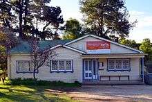
Braemar.jpg) Braemar (1892) | |||||||||||||
|
Springwood | |||||||||||||
| Coordinates | 33°42′0″S 150°33′0″E / 33.70000°S 150.55000°ECoordinates: 33°42′0″S 150°33′0″E / 33.70000°S 150.55000°E | ||||||||||||
| Population | 8,437 (2011 census) | ||||||||||||
| Established | circa 1815 | ||||||||||||
| Postcode(s) | 2777 | ||||||||||||
| Elevation | 371 m (1,217 ft) | ||||||||||||
| Location | 72 km (45 mi) west of Sydney | ||||||||||||
| LGA(s) | City of Blue Mountains | ||||||||||||
| State electorate(s) | Blue Mountains | ||||||||||||
| Federal Division(s) | Macquarie | ||||||||||||
| |||||||||||||
| |||||||||||||
Springwood is a town in the Blue Mountains, New South Wales, Australia. Springwood is located 72 kilometres west of Sydney in the local government area of the City of Blue Mountains. At the 2011 census, Springwood had a population of 8,437 people.[1]
Springwood is near the Blue Mountains National Park and the Greater Blue Mountains Area World Heritage Site. It is 371 metres above sea level and, like most of the towns in the vicinity, is located on a narrow ridge between two gorges. Winmalee is to the north. Springwood railway station sits between Valley Heights and Faulconbridge on the Blue Mountains railway line.
History
The Springwood area was first occupied by the Oryang-Ora aboriginal clan belonging to the wider Darug aboriginal tribe of the wider Sydney region. Their existence in the area dates back to approx 40,000 years of settlement with many rock carvings & art sites in the area. At the time of settlement the Chief of the clan was Oryang Jack who was drawn by French Artist Pellier (Ref Mitchell Library) Oryang-Ora was also the reference to the area that marked the dividing ridge line between the Darug tribes of the north and the Gundungurra tribes to the south in the Blue Mountains area.
In 1815, Governor Lachlan Macquarie and his wife stopped by what Macquarie called a spring. The place was later named Springwood: "Spring" from the springs in the area, and "wood" from the local Mountain Blue Gums (Eucalyptus deanei) of the area.[2] As a town developed, the main street was named Macquarie Road, after Governor Macquarie.
The first railway line was put through the Blue Mountains in 1867, and the Springwood station was built in 1868. This station was replaced by a more substantial building in the Victorian Gothic style, constructed in 1884 under the direction of John Whitton, Chief Engineer of NSW Railways; a porter's cottage was constructed just west of the station. Springwood Station is the second-oldest surviving station in the Blue Mountains. It is listed on the Register of the National Estate[3] as well as having a New South Wales heritage listing.[4]
In 1892, James Hunter Lawson built Braemar, a large, single-storey house situated on a sixty-acre property on Macquarie Road. Braemar started as a family residence, but later became a convalescent home, a boarding house, a private home again and a guesthouse. It was acquired by the Blue Mountains City Council in 1974, restored as a Bicentennial project and reopened in 1988. It serves as a community gallery and centre, staffed by volunteers. The local library is housed in a new building behind Braemar.[5]
Christ Church Anglican Church was built on the Great Western Highway from 1888-89, with extensions in the 1960s and 1980s. It was designed by the architect Sir John Sulman, who had a holiday residence at Lawson. Designed in the Victorian Academic Gothic style, the church is the oldest Anglican church building in the Blue Mountains and is heritage-listed.[6] The original vicarage, now a private residence known as Southall, is also heritage-listed.[7]
The Presbyterian Church building, a sandstone Gothic building located on Macquarie Road, was built in 1895. The Catholic community was originally part of the Penrith parish, but were given their own building in 1892: St Thomas Aquinas Church. The church has since relocated to St Columba's grounds, Winmalee.
October 2013 bushfires
A small part of Springwood, along with larger parts of the adjacent town of Winmalee and nearby village of Yellow Rock were badly affected by bushfires in October 2013. 193 residential properties were destroyed, and 109 damaged in those localities.[8]
Commercial area and transport

Springwood's commercial area centres around Macquarie Road which runs parallel to the Great Western Highway and the railway line. Springwood railway station is on the Blue Mountains Line of the NSW TrainLink intercity network. Blue Mountains Bus Company also makes daily trips through Springwood from Penrith & Katoomba, and also various bus routes depart Springwood for Burns Road, Springwood Hospital, Hazelbrook, Winmalee and Yellow Rock.[9]
Education
The town is serviced by three high schools, Springwood High School, Winmalee High School and St. Columba's High School, as well as private and selective high schools in other suburbs. Springwood is also serviced by five primary schools: Ellison Public School, Faulconbridge Public School, Winmalee Public School, Springwood Public School and St Thomas Aquinas Primary School.
Churches
Christ_Church_Springwood-1.jpg)
- Christ Church Anglican Church (1888)[10]
- Springwood Baptist[11]
- Springwood Presbyterian[12] meeting at Frazer Presbyterian Church (1895)
- Springwood Salvation Army[13]
- Springwood Uniting Church[14]
- St. Thomas Aquinas Catholic Church
- Lutheran Springwood[15]
- Springwood Family Church [16]
Climate
Springwood generally has mild winters and mild summers, but can suffer bushfire damage during the spring and summer months. It has a rainfall of approximately 1175 mm per year.[17] The mean annual maximum temperature is 22 °C with the mean maximum in January approximately 28 °C and 18 °C in July. The mean minimum temperature is 9 °C (Bureau of Meteorology).[18]
Celebrations and events
The town's annual celebration, Foundation Day, occurs in late March to early April.[19]
Springwood is also the site of a notable ANZAC Day Parade.
The Blue Mountains Vietnam Veterans' Association conducts the largest annual parade and Memorial Service for Vietnam veterans in Australasia[20] at Springwood, on the third Sunday of August, to coincide with the anniversary of the Battle of Long Tan.
Springwood Australia Day Festival, conducted by Lower Mountains Fundraising Events Inc., is held in the grounds of Springwood Public School and involves local entertainers on 2 stages, Food and Market Stalls and Amusement Rides.[21]
Springwood Springtopia Festival is held on the first Saturday of September with a similar format to Australia Day.[22]
Parks and recreation
Springwood has some parklands with bushwalks often leading into wilderness areas. Fairy Dell is located immediately south of the township and has some tracks leading into the Blue Mountains World Heritage area. The Deanei Reserve is another bushland area which is located east of the township and hosts the threatened and endangered Blue Mountains Shalecap Forest. There are also bushland walks in this bushland Reserve.
Buttenshaw Park is also a recreational area which hosts an arboretum, play structures and the Springwood Pool.
Summerhayes Park is a public reserve located in Winmalee, which is used for sport and recreational activities. Its facilities include tennis and netball courts, a newly built skate park and fields for Football (soccer) both local (NDSFA) and Representative (FNSW) all year round. It is the home of Springwood United Football Club (formerly Springwood Soccer & Sports Club) [8] and Springwood Netball Club. Summerhayes Park has diverse native flora and fauna and contains many threatened/endangered species and ecological communities. It is also a bushwalking area with many tracks, vistas and aboriginal archeological sites.
Tourist attractions
Valley Heights Locomotive Depot Heritage Museum is the home of the oldest remaining roundhouse in New South Wales, located 500 m from the eastern Springwood town boundary.
Population
Springwood is the largest town in the lower Blue Mountains. According to the 2011 Census, there were 8437 people living in Springwood including 3909 males (46.3%) and 4528 females (53.7%). The majority (80.9%) were born in Australia. The indigenous populace of Springwood is 146 or 1.7% of the total population. The most common responses for religion were No Religion 25.1%, Catholic 23.6%, Anglican 22.5%, Presbyterian and Reformed 4.6% and Baptist 4.1%.[23]
See also
References
- ↑ "Springwood (State Suburb' 2011 Census QuickStats)". abs.com.au. Australian Bureau of Statistics. 30 October 2012. Retrieved 16 January 2013.
- ↑ Blue Mountains City Council website: Origin of Blue Mountains Town Names
- ↑ The Heritage of Australia, Macmillan Company, 1981, p.2/13
- ↑ NSW Heritage Office database: Springwood Railway Station Group
- ↑ Braemar Gallery website
- ↑ NSW Government Heritage site
- ↑ State Heritage Register
- ↑ "Watch and Act - Linksview Road Fire, Springwood (Blue Mountains) 19/10/13 11:40". New South Wales Rural Fire Service. 19 October 2013. Retrieved 19 October 2013.
- ↑ Blue Mountains Bus Company
- ↑ http://springwoodanglican.org.au/ Anglican Churches Springwood
- ↑ http://www.springwoodbaptist.org.au/ Springwood Baptist Church
- ↑ http://www.springwoodchurch.org.au/ Springwood Winmalee Presbyterian Church
- ↑ http://www.salvos.com/springwood/ Springwood Salvation Army
- ↑ http://springwood.unitingchurch.org.au/ Springwood Uniting Church
- ↑ http://www.lca.org.au/search/church/cong.cfm?orgcode=springwood Lutheran Church of Our Saviour - Springwood
- ↑ http://www.acctv.com.au/church_view.asp?intid=3080 Springwood Family Church
- ↑ Blue Mountains City Council: Weddings in the City of the Blue Mountains
- ↑ Blue Mountains City Council: Jackson Park Draft Plan of Management (2005) -- 4km west of Springwood
- ↑ http://www.foundationday.org.au
- ↑ Blue Mountains Vietnam Veterans website
- ↑ LMFE Inc. http://www.lmfe.org.au
- ↑ LMFE Inc. http://www.lmfe.org.au
- ↑ "Springwood (State Suburb' 2011 Census QuickStats)". abs.com.au. Australian Bureau of Statistics. 30 October 2012. Retrieved 16 January 2013.
| Wikivoyage has a travel guide for Springwood (New South Wales). |
| Wikimedia Commons has media related to Springwood, New South Wales. |