Narrow Neck Plateau
| Narrow Neck Plateau | |
|---|---|
|
Narrow Neck Plateau in the rain at sunset, Blue Mountains National Park. | |
| Highest point | |
| Elevation | 1,000 m (3,300 ft) |
| Coordinates | 33°45′37″S 150°15′55″E / 33.76028°S 150.26528°ECoordinates: 33°45′37″S 150°15′55″E / 33.76028°S 150.26528°E |
| Geography | |
 Narrow Neck Plateau Location of the Narrow Neck Plateau | |
| Location | Blue Mountains, New South Wales, Australia |
| Parent range | Blue Mountains |
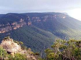
The Narrow Neck Plateau, an eroded remnant of a sandstone layer situated at an elevation of 1,000 metres (3,300 ft) above sea level that is part of the Blue Mountains Range which is a spur line off the Great Dividing Range, is situated immediately south-west of Katoomba in New South Wales, Australia, located within the Blue Mountains National Park. The neck separates the Jamison Valley (to the east) from the Megalong Valley (to the west).
Description
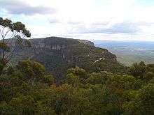
From Cliff Drive, Katoomba, the Narrow Neck is accessed via a dirt road called Glenraphael Drive suitable for most two-wheel drive vehicles, subject to good weather conditions, as far as a locked gate. It is a popular walking, bike riding and climbing location and offers several walking descent routes to the adjacent valleys. Beyond the gate is walking/bicycle access only for the general public. One of the most popular walks is the Golden Stairs, a rough descent of approximately 200 metres (660 ft) to join the Federal Pass. This opens up the Jamison Valley for popular day walks to sites such as Mount Solitary and the Ruined Castle. The neck juts southwards from Katoomba for a distance of some 10 kilometres (6.2 mi) and ends at Clear Hill, overlooking the Wild Dog Mountains. Castle Head promontory points towards the Ruined Castle, a small rock formation between Castle Head and Mount Solitary.[1] Arguably one of the best views on the eastern seaboard of NSW is from Narrow Neck Fire Tower. On a day of high visibility it is possible to see from Mittagong in the south to Toronto in the north and a number of peak landforms in between. It also has excellent views back towards the escarpment at Katoomba.
Missing person
A nineteen-year-old British backpacker Jamie Neale was found after twelve days lost in the Blue Mountains. Two bushwalkers alerted emergency services who were conducting an extensive search using the Police Rescue Squad, police dogs, State Emergency Service and Rural Fire Service.[2]
Fauna
Upland swamps on Narrow Neck Plateau have been identified as potential habitats for the rare Blue Mountain Water Skink.[3]
Points of Interest
- Cahill's Lookout – 33°43′16″S 150°17′09″E / 33.721130°S 150.285934°E
- Carlons Head
- Locked Gate – 33°44′27″S 150°16′48″E / 33.740755°S 150.280110°E
- Malaita Point – 33°44′04″S 150°17′55″E / 33.734543°S 150.298510°E
- Golden Staircase – 33°44′07″S 150°16′57″E / 33.73526°S 150.28259°E
- Castle Head – 33°45′21″S 150°17′14″E / 33.75585°S 150.287223°E
- Fire Tower – 33°47′16″S 150°15′38″E / 33.787783°S 150.260528°E
- Ruined Castle – 33°45′48″S 150°17′38″E / 33.76338°S 150.29397°E
- Clear Hill – 33°48′40″S 150°15′55″E / 33.811090°S 150.265273°E
- Tarro's Ladders
See also
References
- ↑ Paton, Neil (2004). Sydney and Blue Mountains Bushwalks. Kangaroo Press. pp. 222–228.
- ↑ "Missing for 12 days: backpacker Jamie Neale found". The Sydney Morning Herald. 15 July 2009. Retrieved 28 May 2014.
- ↑ "Reptiles" (PDF). Terrestrial Vertebrate Fauna of the Greater Southern Sydney Region - Fauna of Conservation Concern & Priority Pest Species. Environmental and Heritage. Retrieved 28 May 2014.
External links
| Wikimedia Commons has media related to Blue Mountains, New South Wales. |
- Blue Mountains, NSW, Australia Aerial video footage of Narrow neck and the area around Katoomba.
- "Blue Mountains Wilderness", by Harry Loots. From the April 1997 issue of the newsletter of the Harbourside Group of SGAP.