2009 Papua earthquakes
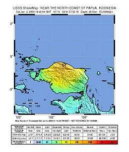 | |
| Date | January 3, 2009 at 19:43:54 UTC [1] |
|---|---|
| Magnitude | 7.6 Mw [1] |
| Depth | 30 km (19 mi) [1] |
| Epicenter | 0°30′S 132°44′E / .5°S 132.74°ECoordinates: 0°30′S 132°44′E / .5°S 132.74°E [1] |
| Type | Thrust [2] |
| Areas affected | Indonesia |
| Max. intensity |
19:43 – VI (Strong) [3] 22:33 – VIII (Severe) [4] |
| Tsunami | 1.8 m (5 ft 11 in) [2] |
| Aftershocks | 7.4 Mw January 3 at 22:33 [4] |
| Casualties | 4 dead, dozens injured |
The 2009 Papua earthquakes occurred on January 4 local time in Indonesia's West Papua province. The very large earthquake doublet comprised a magnitude 7.6 initial shock that had a maximum Mercalli intensity of VI (Strong) and a second very large event that had a moment magnitude of 7.4 and a maximum Mercalli intensity of VIII (Severe). The events took place less than three hours apart to the east-northeast of Sorong on the Bird's Head Peninsula and left at least four people dead and dozens injured.
An official of World Vision International, a humanitarian aid organization, said ten buildings had been totally destroyed, including several hotels and the house of a government official. Officials said three people, who had been staying at the Mutiara hotel in the city of Manokwari, were pulled alive from the rubble and taken to a hospital. Two hotels collapsed in the quake. There have been twenty-three aftershocks above magnitude 5.0 and another at magnitude 6.0. The earthquakes were also felt in nearby Papua New Guinea and Darwin, Australia.[5][6][7]
See also
References
- 1 2 3 4 ISC (2015), ISC-GEM Global Instrumental Earthquake Catalogue (1900–2009), Version 2.0, International Seismological Centre
- 1 2 Poiata, N.; Koketsu, K.; Miyake, H. (2010), "Source processes of the 2009 Irian Jaya, Indonesia, earthquake doublet" (PDF), Earth, Planets and Space, Springer, 62: 475
- ↑ USGS. "M7.7 - near the north coast of Papua, Indonesia". United States Geological Survey.
- 1 2 USGS. "M7.4 - near the north coast of Papua, Indonesia". United States Geological Survey.
- ↑ BBC News - Strong earthquake rocks Indonesia Retrieved on January 4, 2009
- ↑ Indonesia earthquake kills at least four CNN. Retrieved on January 4, 2009
- ↑ Quake hits Indonesia's Papua island, four dead Reuters. Retrieved on January 4, 2009