2012 Indian Ocean earthquakes
 | |
| Date | 11 April 2012 |
|---|---|
| Origin time | 08:38:36 [1] |
| Magnitude | 8.6 Mw [1] |
| Epicenter | 2°18′40″N 93°03′47″E / 2.311°N 93.063°ECoordinates: 2°18′40″N 93°03′47″E / 2.311°N 93.063°E [2] |
| Type | Strike-slip – Intraplate [3] |
| Areas affected | Indonesia |
| Max. intensity | VII (Very strong) [4] |
| Tsunami | Yes |
| Foreshocks | 7.2 Mw Jan 10 at 18:36 [1] |
| Aftershocks | 8.2 Mw April 11 at 10:43 [1] |
| Casualties |
10 dead [4] 12 injured [4] |
The 2012 Indian Ocean earthquakes were magnitude 8.6 and 8.2 Mw undersea earthquakes that struck near the Indonesian province of Aceh on 11 April at 15:38 local time. Initially, authorities feared that the initial earthquake would cause a tsunami and warnings were issued across the Indian Ocean; however, these warnings were subsequently cancelled.[5][6] The earthquake was the 13th strongest earthquake since 1900,[7] an unusually strong intraplate earthquake, and the largest strike-slip earthquake ever recorded.[3]
Tectonic setting
The 2012 earthquake's epicenter was located within the Indo-Australian Plate, which is divided into two sub- or proto-plates: the Indian, and Australian. At their boundary, the Indian and Australian Plates converge at 11 mm (0.4 in) per year in a NNW–SSE direction. This convergence is accommodated by a broad zone of diffuse deformation. As part of that intraplate deformation, north–south trending fracture zones have been reactivated from the Ninety East Ridge as far east as 97°E.[8]
The Indo–Australian Plate was formed after the amalgamation of the Indian Plate and the Australian Plate some 45 million years ago.[9] However, there is a relative movement between the Indian Plate and the Australian Plate. A process which would eventually split the Indo-Australian Plate in two probably have started 8 to 10 millions ago and is still taking place. Because of the deformation, fracture zones have been reactivated. The 2012 Indian Ocean earthquake is associated to the reactivation of the NNE-striking sea floor fabric.[10][11]
Earthquake
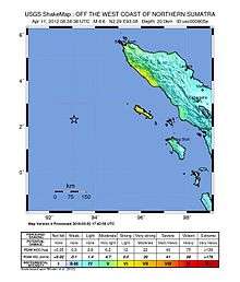
The magnitude 8.6 (Mw) earthquake occurred about 610 km (379 mi) southwest of Banda Aceh, Indonesia at 08:38 UTC on 11 April 2012. The earthquake occurred at a depth of 22.9 km (14.2 mi), which is considered relatively shallow according to the scale used by the United States Geological Survey (USGS).[2] The quake was originally reported as a magnitude 8.9, but was later downgraded to 8.6. It was felt as far away as Malaysia, the Maldives and in India.[12] The earthquake was caused by a strike-slip motion. The earthquake and the largest aftershock had a fault displacement of 21.3 m (70 ft).[7] The strike-slip nature of the earthquake meant that the movement displaced relatively little seawater and was less likely to cause a tsunami.[13]
Both the initial earthquake and the magnitude 8.2 aftershock were classified (based on their focal mechanisms) as strike-slip earthquakes, meaning that the crust on either side shifted against each other horizontally, rather than vertically. Since 2006 there have been three other earthquakes in the area with a similar faulting style. All these earthquakes were consistent with either left-lateral slip on SSW–NNE orientated strike-slip faults, or right-lateral slip on WNW–ESE orientated strike-slip faults, both compatible with the direction of convergence.[14] A back projection analysis of data collected by Hi-net, an observation network in Japan, found a complex pattern of four conjugate faults. There was a strong correlation between the fault rupture pattern and the distribution of the aftershocks.[15]
These earthquakes have a complex rupture process. The rupture of these earthquakes occurred on multiple, almost orthogonal faults. This is rare in a single earthquake. This earthquake had an overall relatively slow rupture speed, although the speed was above the S-wave velocity in some fault segments.[15][16] The rupture may have affected the crust and the upper mantle according to the kinematic source inversion.[17] The rupture was caused by ductile shear heating instability which is different from frictional failure and operates between 600–800 °C (1,112–1,472 °F), which corresponds to about the depths of 40–60 km (25–37 mi). The serpentinization of oceanic lithosphere can lead to a low friction coefficient, but the reaction is possible only up to 400–500 °C (752–932 °F), which corresponds to the depth of about 25 km (16 mi). A single dynamic weakening mechanism which can work over the whole range of slip of this earthquake is still to be identified.[16][18]
Damage
Four people in their 60s and 70s in Banda Aceh, and a 39-year-old man in Lhokseumawe died from heart attacks or shock. Injuries were reported in Aceh Singkil, including a child who was critically injured by a falling tree.[19] The quake prompted people in Indonesia, Thailand and India to leave their homes and offices in fear of tsunamis.[20] People headed for higher ground in parts of Indonesia and Malaysia.[12][21] In Aceh, where 31,000 people were killed in the 2004 Indian Ocean earthquake and tsunami, people were reported weeping.[22] Some people used cars and motorcycles to reach higher ground. Patients were reportedly wheeled out of hospitals, some with drips attached to their arms. One hotel guest was slightly injured when he jumped out of his window.[23]
The earthquake was felt over a large area, including Indonesia, the Maldives, Sri Lanka, India, Nepal, Bhutan, China, Bangladesh, Burma, Thailand, Malaysia, Laos, Cambodia, Singapore, and Vietnam.[24][25][26] The quake was felt across the eastern coast of India including Chennai, Bangalore, Kochi, Bhubaneswar, Vizag and Kolkata. The Metro Rail services were suspended in Kolkata, and passengers were asked to leave stations.[27] In peninsular Malaysia, shaking was felt in Penang and Kuala Lumpur.[28] The tremor was felt in Colombo, Sri Lanka, where people in some high-rise buildings were evacuated.[29] In China, the earthquake was felt in Tibet. However, it was not reported to be felt in places closer to the epicenter such as Yunnan and Guangxi.[30]
Aftershocks
A magnitude 8.2 aftershock struck at a depth of 16.4 kilometres (10.2 mi) about 430 km (267 mi) southwest of Banda Aceh at 10:43 UTC, two hours after the initial earthquake.[31] Many aftershocks with magnitude readings between 5.0 and 6.0 were recorded for several hours after the initial earthquake which hit the west coast of northern Sumatra.[32][33] Since the initial magnitude 8.6 earthquake, there have been 111 aftershocks over magnitude 4.0 according to USGS, including a magnitude 6.2 on April 15, 2012.[34][35]
Tsunami warnings

Three hours after the initial quake it was still unclear whether a tsunami had been generated or if a tsunami had done any significant damage. A geophysicist from the Pacific Tsunami Warning Center (PTWC) stated that a gauge closest to the epicenter recorded a wave peak of about 1 m (3 ft).[36] The Pacific Tsunami Warning Center said that at 10:14 UTC that a tsunami was generated and may have already caused some coastal destruction.[37] A seismologist from the British Geological Survey[38] said that the "tearing earthquake" displaced relatively little water and was therefore unlikely to cause a significant tsunami.[24] Indonesian authorities also issued a statement saying that the likelihood of a tsunami was low.[39]
Tsunami warnings were issued in the following countries: Indonesia, Australia, Cambodia, Malaysia, Singapore, Thailand, Myanmar, Bangladesh, India, Sri Lanka, Maldives, Pakistan, Iran, United Arab Emirates, Oman, Yemen, Somalia, Kenya, Tanzania, Seychelles, Mozambique, Mauritius, Comoros, Madagascar, South Africa and the dependencies of Diego Garcia as part of the British Indian Ocean Territories, Crozet Islands, Réunion and Kerguelen Islands. Projected tsunami landfall times in GMT were: 8:38 for Indonesia, 11:38 for Sri Lanka, 14:38 for the Seychelles, 17:38 for Madagascar and 20:38 for South Africa.[12]
India
After the earthquake, the Indian National Centre for Ocean Information Services (INCOIS) issued a high-level tsunami warning for the Andaman and Nicobar Islands.[40] Authorities told civilians to move away from the coast and towards higher ground.[41] Areas subject to warnings included Tamil Nadu, Andhra Pradesh and the Union Territory of Andaman and Nicobar Islands.[42] Prabkhakar Rao of the disaster control room in Port Blair said that there could be tsunamis as high as 1.5 m (4.9 ft) at Port Blair and 3.9 m (12.8 ft) at Campbell Bay.[12]
In Kolkata, underground Metro Railways services were stopped and tall office buildings and shopping malls were evacuated. Navy warships were put on high alert. The Indian Air Force dispatched two C-130s and one Il-76 aircraft to the Andaman islands.[43]
Sri Lanka
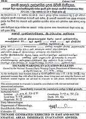
The Ministry of Disaster Management and Human Rights (DMC) authorised an evacuation order[44] at 9:08 UTC advising people living near coastal regions to move to higher ground. The initial quake was not expected to affect Sri Lanka, but aftershocks were being monitored.[45] Deputy Director M. D. Dayananda said that a tsunami could hit Trincomalee.[12]
As part of a risk mitigation measure, the Ceylon Electricity Board disconnected power supplies to coastal areas and railway control rooms. Coastal train services were suspended.[46] The Road Development Authority removed toll charges from the Southern Sri Lanka Distributor to aid the evacuation.[47] Coastal bus services were temporarily re-routed.[48]
Thailand
Six Andaman coast provinces urged people to go to high ground and stay away from areas that could be affected. Phuket International Airport was closed.[12] The alerts caused panic as people fled buildings and made for high ground.
During the initial earthquake and for more than two hours after none of Thailand's free television stations reported the earthquake or tsunami warnings, preferring to continue a live broadcast of a royal family ceremony, despite the National Broadcasting and Telecommunications Commission (NBTC)'s urgent order directing the emergency information to be broadcast instead without delay.[49] This caused criticism on the internet, although it was muted by a lèse majesté law.[50] The Television Pool of Thailand defended their actions, saying that running texts about the warnings were displayed onscreen during the broadcast.[50]
Tsunami
Small 0.5 m (20 in) waves, within regular tide limits, were reported in the Campbell Bay area of Great Nicobar Island,[12] and 10 cm (4 in) waves were reported in Thailand.[51][52] The Indonesian Agency for Meteorology, Climatology and Geophysics said three small tsunamis struck the Aceh coast. The highest was 80 cm (31 in), at Meulaboh.[53] After the sea was seen receding about 10 metres (33 ft) at Simeulue, a 1 m (3 ft) wave was observed. Simeulue is an island of fishing villages 150 km (93 mi) off the west coast of Sumatra.[54]
See also
References
- 1 2 3 4 Wei, S.; Helberger, D.; Avounac, J-P. (2013), "Modeling the 2012 Wharton Basin earthquakes off-Sumatra: Complete Lithospheric failure" (PDF), Journal of Geophysical Research, American Geophysical Union , 118 (7): 3595, Bibcode:2013JGRB..118.3592W, doi:10.1002/jgrb.50267
- 1 2 "Magnitude 8.6 – OFF THE WEST COAST OF NORTHERN SUMATRA". United States Geological Survey. 11 April 2012. Retrieved 11 April 2012.
- 1 2 Prasad, R. (12 April 2012). "Why April 11 quake was caused by a strike-slip fault". Chennai, India: The Hindu. Retrieved 13 April 2012.
- 1 2 3 USGS. "M8.6 - off the west coast of northern Sumatra". United States Geological Survey.
- ↑ NewsCore (11 April 2012). "Indian Ocean tsunami alert cancelled after two strong quakes hit off Sumatra, Indonesia". Herald Sun. Retrieved 11 April 2012.
- ↑ "Huge quake strikes off Indonesia, tsunami warning issued". Reuters. 11 April 2012. Retrieved 11 April 2012.
- 1 2 "Scientists: Magnitude-8.6 Indonesia jolt was unusually large for a strike-slip quake; Winnipeg Free Press". Canadian Press. 11 April 2012. Retrieved 11 April 2012.
- ↑ Kreemer, C.; Holt W.E. & Haines A.J.; Haines, A. John (2003). "An integrated global model of present-day plate motions and plate boundary deformation" (PDF). Geophysical Journal International. Royal Astronomical Society. 154: 8–34. Bibcode:2003GeoJI.154....8K. doi:10.1046/j.1365-246X.2003.01917.x. Retrieved 12 April 2012.
- ↑ Sanford, M.; Coblentz, D.D.; Richardson, R.M. (1995), "Ridge torques and continental collision in the Indian-Australian plate" (PDF), Geology, Geological Society of America , 23 (7): 653–656, Bibcode:1995Geo....23..653S, doi:10.1130/0091-7613(1995)023<0653:RTACCI>2.3.CO;2
- ↑ "April Sumatra quakes signal Indian ocean plate break-up". BBC News. 26 September 2012.
- ↑ "The 2012 Mw 8.6 Sumatra earthquake: Evidence of westward sequential seismic ruptures associated to the reactivation of a N-S ocean fabric" by C. Satriano, E. Kiraly, P. Bernard, and J.-P. Vilotte
- 1 2 3 4 5 6 7 "Indian Ocean on tsunami alert after quakes". Al Jazeera. 11 April 2012. Retrieved 11 April 2012.
- ↑ "Explained: What is a slip-strike quake, and why there was no tsunami - World - DNA". Dnaindia.com. 2012-04-11. Retrieved 2012-08-13.
- ↑ United States Geological Survey (11 April 2012). "Poster of the M8.6 Northern Sumatra, Earthquake of 11 April 2012" (PDF). Retrieved 12 April 2012.
- 1 2 Wang, D.; Mori, J.; Uchide, T. (2012). "Supershear rupture on multiple faults for the Mw 8.6 Off Northern Sumatra, Indonesia earthquake of April 11, 2012". Geophysical Research Letters. American Geophysical Union. 39 (21): n/a. Bibcode:2012GeoRL..3921307W. doi:10.1029/2012GL053622.
- 1 2 Meng L., L.; Ampuero, J.-P.; Stock, J.; Duputel, Z.; Luo, Y.; Tsai, V.C. (2012). "Earthquake in a Maze: Compressional Rupture Branching During the 2012 Mw 8.6 Sumatra Earthquake" (PDF). Science. American Association for the Advancement of Science. 337 (6095): 724–726. Bibcode:2012Sci...337..724M. doi:10.1126/science.1224030.
- ↑ "Séismes au large de Sumatra mercredi 11 avril 2012" (in French). Institut de Physique du Globe de Paris. Retrieved February 9, 2013.
- ↑ McGuire, J.; Beroza, G.C. (2012). "A Rogue Earthquake Off Sumatra" (PDF). Science. American Association for the Advancement of Science. 336 (6085): 1118–1119. Bibcode:2012Sci...336.1118M. doi:10.1126/science.1223983.
- ↑ Jakarta BNPB
- ↑ Reuters (11 April 2012). "Massive earthquake strikes Indonesia, tremors felt in India". The Times of India. Retrieved 11 April 2012.
- ↑ "Massive earthquake off Indonesia". TVNZ. 11 April 2012. Retrieved 11 April 2012.
- ↑ NDTV News. "Strong Indonesian quakes cause panic, not tsunami". Associated Press. Retrieved 12 April 2012.
Women and children cried in Aceh, where memories of a 2004 tsunami that killed 170,000 people in that province alone are still raw. Others screamed "God is great" as they poured from their homes or searched frantically for separated family members
- ↑ NDTV News. "Strong Indonesian quakes cause panic, not tsunami". Associated Press. Retrieved 12 April 2012.
- 1 2 "Indian Ocean tsunami alert lifted after Aceh quake". BBC News. 11 April 2012. Retrieved 11 April 2012.
- ↑ "Strong earthquake in Sumatra slightly felt in Yangon – Xinhua | English.news.cn". News.xinhuanet.com. Retrieved 12 April 2012.
- ↑ The Brief » Blog Archive » Tremors felt. Nepali Times. Retrieved on 13 April 2012.
- ↑ PTI (11 April 2012). "News : Tremors across eastern coast; people evacuated from Andamans". Chennai, India: The Hindu. Retrieved 11 April 2012.
- ↑ "8.6 earthquake hits Aceh, tsunami alert issued (Update) | theSundaily". Thesundaily.my. 11 April 2012. Retrieved 11 April 2012.
- ↑ "Large Aceh quake triggers Indian Ocean tsunami warning – Tremor felt in Colombo | Independent Television Network News". Itnnews.lk. 11 April 2012. Retrieved 11 April 2012.
- ↑ 专家表示:印尼地震造成我国西藏地区有震感属正常 – 新华社会 – 新华网. News.xinhuanet.com. Retrieved on 13 April 2012.
- ↑ "8.2-magnitude aftershock hits off Sumatra". US Geological Survey (USGS). 11 April 2012. Retrieved 11 April 2012.
- ↑ "M8.2 – off the west coast of northern Sumatra". United States Geological Survey. 11 April 2012. Retrieved 11 April 2012.
- ↑ "Latest Earthquakes M5.0+ in the World – Past 7 days". Earthquake.usgs.gov. 11 April 2012. Retrieved 11 April 2012.
- ↑ "10-degree Map Centered at 0°N,90°E". U.S. Geological Survey. 16 April 2012. Retrieved 16 April 2012.
- ↑ "Magnitude 6.2 - off the West Coast of Northern Sumatra". U.S. Geological Survery. 15 April 2012. Retrieved 16 April 2012.
- ↑ "Indonesia earthquake: No damage to ocean basin, India withdraws tsunami warning". The Indian Express. 11 April 2012. Retrieved 11 April 2012.
- ↑ "Pacific Tsunami Warning Center/NOAA/NWS: Tsunami bulletin number 003". PTWC. 11 April 2012. Retrieved 11 April 2012.
- ↑ "Staff Profile of Dr Roger Musson | British Geological Survey". BGS. Retrieved 12 April 2012.
- ↑ "Watch: Indonesia Reacts to 8.7 Magnitude Earthquake". TIMES. 11 April 2012. Retrieved 11 April 2012.
- ↑ AFP (11 April 2012). "Indonesia earthquake: India issues tsunami warning for Andaman and Nicobars". The Times of India. Retrieved 11 April 2012.
- ↑ "Earthquake in Indonesia: How India responded". NDTV. 11 April 2012. Retrieved 11 April 2012.
- ↑ "Earthquake in Indonesia: India withdraws tsunami warning". NDTV. 11 April 2012. Retrieved 11 April 2012.
- ↑ TOI, Times of India (12 April 2012). "8.6 magnitude quake in Aceh triggers tsunami fears in India". Times Group.
- ↑ "Tsunami warning in South and East | Top Story". Daily Mirror. 11 April 2012. Retrieved 11 April 2012.
- ↑ "Tsunami Warning Evacuation Bulletin". 11 April 2012. Retrieved 11 April 2012.
- ↑ "Trains stopped, power to be disconnected | Breaking News". Daily Mirror. 11 April 2012. Retrieved 11 April 2012.
- ↑ "Expressway free of charge | Breaking News". Daily Mirror. 11 April 2012. Retrieved 11 April 2012.
- ↑ "Private buses stop in coastal areas | Breaking News". Daily Mirror. 11 April 2012. Retrieved 11 April 2012.
- ↑ "สุภิญญา"ชี้แจง "กสทช."ร่อนจดหมายด่วนฟรีทีวีทุกช่อง "นำเสนอข่าวแผ่นดินไหว-สึนามิ" [Suphinya shows up the NBTC letter ordering every free television channel to present earthquake-tsunami news] (in Thai). Matichon. 11 April 2012.
- 1 2 "ทีวีพูล"แผ่นดินไหวช่วงพระราชพิธี [TV Pools, Earthquake and Royal Ceremony] (in Thai). ThaiPBS. 12 April 2012.
- ↑ "Small tsunami reaches Thailand after huge quake". The Daily Star. 11 April 2012. Retrieved 11 April 2012.
- ↑ "Strong Indonesian quakes cause panic across Asia, not tsunami". Emirates 24/7. 11 April 2012. Retrieved 11 April 2012.
- ↑ "Update: Indonesia Lifts Tsunami Warning, Residents Return Home". Jakarta Globe. 11 April 2012. Retrieved 11 April 2012.
- ↑ "Terrified Indonesian island survives quake – Yahoo!7". Au.news.yahoo.com. Archived from the original on 13 April 2012. Retrieved 12 April 2012.
- Sources
- Pollitz, F.F.; Bürgmann, R.; Stein, R.S.; Sevilgen, W. (2014), "The Profound Reach of the 11 April 2012 M8.6 Indian Ocean Earthquake: Short-Term Global Triggering Followed by a Longer-Term Global Shadow" (PDF), Bulletin of the Seismological Society of America, Seismological Society of America, 104 (2): 972–984, Bibcode:2014BuSSA.104..972P, doi:10.1785/0120130078
External links
| Wikinews has related news: Massive earthquake hits Indonesia, no tsunami risk |
-
 Media related to 2012 Indian Ocean earthquake at Wikimedia Commons
 - Satellite View at Wikimapia.org
- Preliminary source parameters obtained by automatic analysis - 2012/04/11 08:38 Off West Coast of Northern Sumatra – International seismic network, NIED, Japan
- After major earthquake, silence: Dynamic stressing of a global system of faults results in rare seismic silence – Science Daily
- Rare great earthquake in April triggers large aftershocks all over the globe – Science Daily