2012 Guerrero–Oaxaca earthquake
 | |
| Date | 20 March 2012 |
|---|---|
| Origin time | 12:02 |
| Duration | 40–300 seconds[1] |
| Magnitude | 7.4 MW[2][3] |
| Depth | 15[3] or 20 km[2] |
| Epicenter | 16°25′N 98°22′W / 16.42°N 98.36°WCoordinates: 16°25′N 98°22′W / 16.42°N 98.36°W |
| Type | Thrust |
| Areas affected | Mexico |
| Total damage | Some rural areas affected.[1] Over 30,000 houses damaged or destroyed.[4][5][6] |
| Max. intensity | VII (Very strong) |
| Aftershocks | 6.0 MW March 2 at 15:36[7] |
| Casualties | 2 deaths,[8][9] 11 people injured.[6][10] |
The 2012 Guerrero–Oaxaca earthquake struck southern Mexico with a moment magnitude of 7.4 at 12:02 local time on Tuesday, 20 March. Its epicenter was near Ometepec, in the border between the states of Guerrero and Oaxaca. With a shallow focus of 15 to 20 km, the earthquake caused strong shaking over a large area along the Oaxaca–Guerrero border and the adjacent Pacific coastline. Significant tremors were felt in areas up to several hundred kilometers away, including Mexico City and also in Guatemala. Two people were killed and over 30,000 houses were damaged or destroyed.
Tectonic setting
The states of Guerrero and Oaxaca lie above the convergent boundary where the Cocos Plate is being subducted below the North American Plate at a rate of 6.4 cm/yr (2.5 in/yr). The dip of the subducting slab is about 15° as defined by focal mechanisms and hypocenters of previous earthquakes. Seismicity in this area is characterized by regular megathrust earthquakes along the plate interface. In addition, there have been a series of historic normal fault events within the subducting slab.[11]
Earthquake
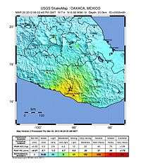
According to the National Seismological Service (NSS) of Mexico, the epicenter was located in the Oaxaca-Guerrero border, about 30 km south of Ometepec and 8 km southeast of Cuajinicuilapa.[3] The United States Geological Survey (USGS) reported the epicenter in the state of Oaxaca, about 23 km east of Ometepec and 6 km northwest of San Juan Cacahuatepec.[2] The depth was reported as 15 km by NSS[3] and 20 km by the USGS.[2] The slip of the earthquake was compactly distributed in an area of about 30 km × 30 km.[12]
The focal mechanism and depth of the earthquake indicate that it was a result of thrust faulting along or close to the plate interface. Similar earthquakes have struck the area before, including the 1932 Jalisco earthquake, the 1985 Mexico City earthquake, the 1995 Colima–Jalisco earthquake and the 2003 Colima earthquake.[2]
The earthquake coincided with an earthquake drill in Chiapas. The earthquake drill, simulating an earthquake of magnitude 7.9 on the Richter scale, was implemented by the Protección Civil of Chiapas on 20 March. The earthquake drill started at 12:00, and the real earthquake occurred just minutes later.[13]
Damage
The airport of Mexico City was closed for a short time and reopened after no damage had been observed.[14] The trading of Mexican Stock Exchange (BMV) was suspended.[15] The earthquake caused power outage in central and eastern Mexico and affected 2.5 million users according to Comisión Federal de Electricidad (CFE).[16] On 22 March it was announced that two people were killed in Cuajinicuilapa because of the earthquake, one direct and one indirect. The first died due to the injuries caused after a wall collapsed on him in El Tamale community, while the second suffered a heart attack, in San Nicolás.[8]
Intensity
The earthquake struck during the midday in a moderately populated region, with a mix of earthquake-resistant and vulnerable structures.[17] The strongest ground motions registered at very strong (MM VII) on the Mercalli intensity scale, affecting smaller cities and towns near the epicenter such as San Juan Cacahuatepec, Cuajinicuilapa, Ometepec and Pinotepa Nacional. Many other areas in the states of Guerrero and Oaxaca experienced strong (MM VI) shaking, while larger cities — such as Huajuapan de León, Oaxaca, Tehuacán, Puebla, and Acapulco, Guerrero — experienced moderate (MM V) tremors. Lighter ground motions (MM IV–III) spread through much of south-central Mexico.[17] The earthquake could be felt in the federal entities of Guerrero, Mexico City, State of Mexico, Morelos, Querétaro, Michoacán, Puebla, Tabasco, Tlaxcala, Hidalgo, Oaxaca, Chiapas, Veracruz, Colima, Jalisco, San Luís Potosí, Guanajuato, Campeche, and Sinaloa of Mexico, and also in Guatemala.[15][18][19][20][21][22][23][24][25] The intensity in Mexico City was MM VI-VII, which was stronger than the surrounding area because of local topography and soil conditions.[26] Part of a pedestrian bridge collapsed on a small passenger bus in Azcapotzalco, Mexico City, with no injuries reported.[18][27] The service of Mexico City Metro Line A was interrupted because of track damage.[28]
Aftershocks
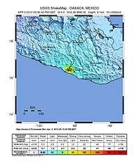
Multiple aftershocks have been reported in the Guerrero–Oaxaca region. According to the NSS, 828 aftershocks have occurred,[29] the strongest of them was felt on 2 April 2012. It was a magnitude 6.0 MW earthquake that struck at 12:36 local time (18:36 UTC).[30][31]
Aftermath
According to Asociación Mexicana de Instituciones de Seguros (AMIS), it was estimated that insurance companies would have to pay 2070 million pesos due to this earthquake. 80% of the loss was concentrated in Guerrero, followed by Mexico City, Oaxaca, and Puebla.[32]
References
- 1 2 "México: Evento de Terremoto duró al menos 5 minutos o más, opinion" [Mexico: Earthquake's duration of 5 minutes or more, Excélsior]. Excélsior (in Spanish). Grupo Imágen. 20 March 2012. Retrieved 20 March 2012.
- 1 2 3 4 5 "Magnitude 7.4 – OAXACA, MEXICO". United States Geological Survey (USGS). 20 March 2012. Retrieved 20 March 2012.
- 1 2 3 4 "Cálculo de la Magnitud Definitiva para el Sismo del 20 Marzo de 2012 en Ometepec, Guerrero." (PDF). Servicio Sismológico Nacional. National Autonomous University of Mexico. 21 March 2012. Retrieved 21 March 2012.
- ↑ "Daña miles de casas" [Damaged thousands of homes]. Diario de Yucatán (in Spanish). Grupo Megamedia. 22 March 2012. Retrieved 22 March 2012.
- ↑ Ayala, Lolita (22 March 2012). El noticiero con Lolita Ayala (in Spanish). Mexico City. Televisa. XEW-TV.
- 1 2 Vervaeck, Armand; Daniell, James (22 March 2012). "Earthquake in Guerrero – Oaxaca, Mexico – at least 32000 houses damaged in Guerrero, 11 injured". SOS Earthquakes. Retrieved 22 March 2012.
- ↑ USGS, M6.0 - Oaxaca, Mexico, United States Geological Survey
- 1 2 "Anuncian que dos personas murieron por el terremoto del martes en México" [Announced that two people were killed by the earthquake on Tuesday in Mexico] (in Spanish). BBC News. BBC. Retrieved 23 March 2012.
- ↑ "Two die of injuries suffered in Mexico quake". The New Zealand Herald. APN News & Media. 23 March 2012. Retrieved 23 March 2012.
- ↑ "Nación – De 7.93 grados, el sismo en México, rectifica el SSN" [Nation – From 7.93 degrees, the earthquake in Mexico, corrected the NSS]. El Universal (in Spanish). El Universal Compañía Periodística Nacional S.A. de C.V. 20 March 2012. Retrieved 20 March 2012.
- ↑ Singh, S.K.; M. Ordaz; L. Alcantara; N. Shapiro; V. Kostoglodov; J. F. Pacheco; S. Alcocer; C. Gutierrez; R. Quaas; T. Mikumo; E. Ovando; J. Aguirre; D. Almora; J. G. Anderson; M. Ayala; C. Javier; G. Castro; R. Duran; G. Espitia; J. Estrada; E. Guevara; J. Lermo; B. Lopez; O. Lopez; M. Macias; E. Mena; M. Ortega; C. Perez; J. Perez; M. Romo; M. Ramirez; C. Reyes; R. Ruiz; H. Sandoval; M. Torres; E. Vazquez; R. Vazquez; J. M. Velasco & J. Ylizaturri. "The Oaxaca earthquake of 30 September 1999 (MW = 7.5)" (PDF). Seismological Research Letters. 71 (1): 67–78. doi:10.1785/gssrl.71.1.67. Retrieved 20 March 2012.
- ↑ http://www.tectonics.caltech.edu/slip_history/2012_Mexico/index.html
- ↑ http://www.nortedigital.mx/article.php?id=6881
- ↑ http://www.ledevoir.com/international/actualites-internationales/345491/un-seisme-de-magnitude-7-9-frappe-le-mexique
- 1 2 http://eleconomista.com.mx/sociedad/2012/03/21/oficinas-gobierno-solicitan-indemnizacion-su-aseguradora
- ↑ http://eleconomista.com.mx/sociedad/2012/03/21/casi-100-restauracion-servicio-cfe-tras-sismo
- 1 2 "PAGER – M 7.4 – Oaxaca, Mexico". United States Geological Survey (USGS). 20 March 2012. Retrieved 20 March 2012.
- 1 2 Pérez, Diane; Carlos Loret de Mola (20 March 2012). El noticiero con Diane Pérez 11:30 (in Spanish). Mexico City. Televisa. FOROtv.
- ↑ Graham, Dave (20 March 2012). "Big earthquake hits Mexico, no major damage reported". Reuters. Retrieved 20 March 2012.
- ↑ http://www.excelsior.com.mx/index.php?m=nota&seccion=seccion-nacional&cat=1&id_nota=820177
- ↑ http://www.televisa.com/programas/tv-abierta-local/guadalajara/noticias/419394/en-diez-municipios-de-jalisco-se-sinti%C3%B3-el-sismo-de-7.8-grados-richter
- ↑ http://tamaulipas.milenio.com/cdb/doc/noticias2011/304c59eb3e4fec5985b35a584e0a1483
- ↑ http://elexpres.com/noticias/news-display.php?story_id=26156
- ↑ http://www.elsur.mx/noticia/17252/sin-afectaciones-en-campeche-por-sismo-informa-cenecam
- ↑ http://www.milenio.com/cdb/doc/noticias2011/304c59eb3e4fec5985b35a584e445cbe
- ↑ http://www.eeri.org/wp-content/uploads/Ometepec-2012-eq-report.pdf
- ↑ "Cae puente peatonal a microbús en Azcapotzalco" [Pedestrian bridge collapses on a minibus in Azcapotzalco] (in Spanish). Terra Networks. 20 March 2012. Retrieved 20 March 2012.
- ↑ http://www.milenio.com/cdb/doc/noticias2011/304c59eb3e4fec5985b35a584e78ddc3
- ↑ "Servicio Sismológico Nacional" [National Seismological Service] (in Spanish). National Seismological Service. National Autonomous University of Mexico. 12 July 2012. Retrieved 14 July 2012.
- ↑ "Sismo de este lunes, otra réplica: SSN" [Monday's earthquake, another aftershock: NSS] (in Spanish). Mexico: W Radio. Televisa Radio. 2 April 2012. Retrieved 2 April 2012.
- ↑ "Nuevo temblor en la Ciudad de México; 6.0 grados" [New earthquake in Mexico City; 6.0 degrees]. Milenio (in Spanish). Grupo Multimedios. 2 April 2012. Retrieved 2 April 2012.
- ↑ http://eleconomista.com.mx/sistema-financiero/2012/03/23/sismo-costara-las-aseguradoras-56-mdp-amis
External links
| Wikimedia Commons has media related to March 2012 Guerrero–Oaxaca earthquake. |