59th Street (BMT Fourth Avenue Line)
| 59th Street | |||||||||||
|---|---|---|---|---|---|---|---|---|---|---|---|
| New York City Subway rapid transit station | |||||||||||
 | |||||||||||
| Station statistics | |||||||||||
| Address |
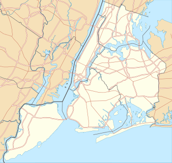
59th Street & Fourth Avenue Brooklyn, NY 11220 | ||||||||||
| Borough | Brooklyn | ||||||||||
| Locale | Sunset Park | ||||||||||
| Coordinates | 40°38′27.88″N 74°1′5.45″W / 40.6410778°N 74.0181806°WCoordinates: 40°38′27.88″N 74°1′5.45″W / 40.6410778°N 74.0181806°W | ||||||||||
| Division | B (BMT) | ||||||||||
| Line | BMT Fourth Avenue Line | ||||||||||
| Services |
N R | ||||||||||
| Transit connections |
| ||||||||||
| Structure | Underground | ||||||||||
| Platforms |
2 island platforms cross-platform interchange | ||||||||||
| Tracks | 4 | ||||||||||
| Other information | |||||||||||
| Opened | June 22, 1915[1] | ||||||||||
| Other entrances/ exits | Fourth Avenue & 60th Street, Fourth Ave & 59th Street | ||||||||||
| Traffic | |||||||||||
| Passengers (2015) |
4,158,863[2] | ||||||||||
| Rank | 120 out of 422 | ||||||||||
| Station succession | |||||||||||
| Next north |
53rd Street (local): N 36th Street (express): N | ||||||||||
| Next south |
Bay Ridge Avenue: R Eighth Avenue (Sea Beach local): N Coney Island–Stillwell Avenue (Sea Beach express): no regular service | ||||||||||
| |||||||||||
| |||||||||||


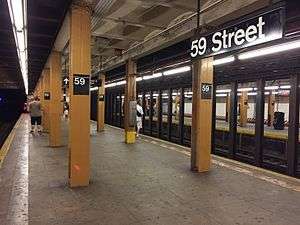
59th Street is an express station on the BMT Fourth Avenue Line of the New York City Subway. Located at 59th Street and Fourth Avenue in the Brooklyn neighborhood of Sunset Park, it is served by the N and R trains at all times.
Station layout
| G | Street Level | Exit/Entrance |
| M | Mezzanine | Fare control, station agent |
| B | Northbound local | ← ← |
| Island platform, doors will open on the left, right | ||
| Northbound express | ← | |
| Southbound express | → (No service: Coney Island–Stillwell Avenue) | |
| Island platform, doors will open on the left, right | ||
| Southbound local | → → | |
This station opened on June 22, 1915.[1] This is the southernmost four-track express station with two island platforms. The outer local tracks continue along Fourth Avenue to Bay Ridge–95th Street while the center express tracks turn east to become the BMT Sea Beach Line. South of the station are two diamond crossovers, allowing trains to cross from the outer track to the center track or vice versa.[3]
The street-level entrances are at the southern end of the station, with one entrance along either side of Fourth Avenue between 60th and 61st Streets. There are also four exits to Fourth Avenue and 59th Street, with two each to either northern corner, at the north end of the station. This station was overhauled in the late 1970s.
The Basilica of Our Lady of Perpetual Help, a major architectural landmark of Brooklyn, is nearby.
Provisions for proposed extensions
Immediately south of the station, one can see tunnel stub headings running straight from the local tracks. They run for about 150 feet and would have been for a line to Staten Island via the Staten Island Tunnel under The Narrows, which was aborted by Mayor Hylan before it was completed.[4][5] There is a Maintenance of Way shed that was built on the southbound trackway.[6] The northbound trackway is unobstructed, albeit much darker.[7] The northbound trackway ends on a brick wall, with evidence of some sort of space beyond. South of this station, the bridge over the LIRR Bay Ridge Branch has four trackways, with the outer tracks occupying the two western ones. The tracks of the BMT Fourth Avenue Line are under the western half of Fourth Avenue at this point so that two additional tracks could be laid in the future if traffic ever warranted it.
Portions of what was to be two additional tracks for the Fourth Avenue subway south of this station were constructed by the then Brooklyn Edison Company initially for use as circuit breaker chambers.
References
- 1 2 "Through Tube to Coney, 48 Minutes: First Train on Fourth Avenue Route Beats West End Line Eleven Minutes". Brooklyn Daily Eagle. June 22, 1915. Retrieved 29 June 2015 – via Newspapers.com.
- ↑ "Facts and Figures: Annual Subway Ridership". New York: Metropolitan Transportation Authority. Retrieved 2016-04-19.
- ↑ Marrero, Robert (2015-09-13). "469 Stations, 846 Miles" (PDF). B24 Blog, via Dropbox. Retrieved 2015-10-09.
- ↑ Staten Island Rapid Transit; The Essential History, by Irvin Leigh and Paul Matus; Page 9 (The Third Rail Online)
- ↑ Taft, Lyman W. (October 13, 1954). "Finds Many Unused Subway Tunnels Under City Streets". Brooklyn Daily Eagle. p. 24. Retrieved 16 September 2015 – via Newspapers.com.
- ↑ https://www.youtube.com/watch?v=FtHPwSuJwHE&feature=related The Maintenance of Way shed can be seen at the 8:55 mark in the video, just after the train leaves the 59th Street station.
- ↑ https://www.youtube.com/watch?v=g5SnwVwN0KM The northbound trackway can be seen at the right, at the 5:58 mark into the video, just before the train approaches the 59th Street station.
External links
| Wikimedia Commons has media related to 59th Street (BMT Fourth Avenue Line). |
- nycsubway.org – BMT 4th Avenue Line: 59th Street
- Station Reporter — N Train
- Station Reporter — R Train
- The Subway Nut — 59th Street Pictures
- 59th Street entrance from Google Maps Street View
- Fourth Avenue entrance, midblock between 60th and 61st Streets, from Google Maps Street View
- Platforms from Google Maps Street View