BMT Fourth Avenue Line
| BMT Fourth Avenue Line | |
|---|---|
|
| |
| Overview | |
| Type | Rapid transit line |
| System | New York City Subway |
| Status | Operational |
| Locale | Brooklyn, New York City, NY |
| Termini |
Court Street Bay Ridge–95th Street |
| Stations | 16 |
| Services | 3 |
| Operation | |
| Opened | 1915-1925 |
| Owner | New York City |
| Operator(s) | New York City Transit Authority |
| Character | Underground |
| Technical | |
| Number of tracks | 2-6 |
| Track gauge | 1,435 mm (4 ft 8 1⁄2 in) |
| Electrification | 600V DC third rail |

The Fourth Avenue Line is a rapid transit line of the BMT division of the New York City Subway, mainly running under Fourth Avenue in Brooklyn. Fourth Avenue never had a streetcar line or elevated railway due to the provisions of the assessment charged to neighboring property owners when the street was widened.[1] The line is served by the D, N, and R. One station, Myrtle Avenue, was abandoned in 1956.
Route
Coming south from DeKalb Avenue and off of Fulton Street, the four-track line runs entirely under Fourth Avenue to just past 59th Street. South of 36th Street, the West End Line (formerly the New Utrecht Avenue elevated line) branches off eastwards, running to its terminus at Coney Island – Stillwell Avenue. Until 1954, the BMT Culver Line also branched off from here, replaced by the Culver Shuttle until 1975. South of 59th Street, after the Sea Beach Line branches off eastwards towards Coney Island via an open-cut right-of-way, the line becomes two-tracked and continues under Fourth Avenue to its terminus at Bay Ridge – 95th Street.[2] While this section of the line was built with two tracks, there were provisions to add two additional express tracks between 59th and 85th Streets if the need was ever to arise.[3]
In its upper section, the line serves Brooklyn Heights and Downtown Brooklyn. The central section serves Park Slope east of Fourth Avenue, on the west side, Boerum Hill then Gowanus; and Sunset Park. In its lower section, it serves the community of Bay Ridge.
Services
The following services use the Fourth Avenue Line:
| Route | Stops | ||||||
|---|---|---|---|---|---|---|---|
| Time period | West of Court St | Between Court St and DeKalb Ave |
DeKalb Ave | Between Atlantic Ave and 36 St |
Between 36 St and 59th Street |
Between 59 St and 95 St | |
| All except nights | no service | express | no service | ||||
| Nights | no service | local | no service | ||||
| All except nights | no service | express | no service | ||||
| Nights | local | no service | |||||
| All times | local | ||||||
The line normally carries the Fourth Avenue R service on the local tracks and the Sea Beach N and West End D services on the express tracks. Manhattan-bound from DeKalb Avenue, the local tracks run via the Montague Street Tunnel to Lower Manhattan, serving either Whitehall Street on the BMT Broadway Line (N, R, W) or Broad Street on the BMT Nassau Street Line (no service; the last service to use these tracks was the M, rerouted in 2010). The express tracks go to Manhattan via the Manhattan Bridge to either the BMT Broadway Line's Canal Street express station (N) or the IND Sixth Avenue Line's Grand Street station (D).[2]
History
The Fourth Avenue Line was built as part of the Dual Contracts. It replaced the parallel elements of an old, now long-ago-demolished elevated system running above Fifth Avenue and Third Avenue.[3]
Groundbreaking for the first section of the subway, between DeKalb Avenue and 43rd Street (ending at 36th Street), took place in November 1909 at DeKalb and Flatbush Avenue.[4] Construction on the southernmost section of the line to 89th Street, just south of the 86th Street station, began in late October 1912.[3][5] The lower section of the line was constructed along with several branch lines, which replaced former surface railroads. These lines are the BMT West End Line splitting south of 36th Street, and the BMT Sea Beach Line leaving south of 59th Street.[3] In anticipation of the opening of the subway, several housing and development booms occurred along Fourth Avenue, particularly in Bay Ridge.[6]
The line opened from 59th Street to 86th Street on January 15, 1916.[7][8][9][10] The final extension to 95th Street opened on October 31, 1925.[11][12]
The line was planned to be connected via one of two tunnels to Staten Island and the Staten Island Railway. The first would be in Bay Ridge, south of the 59th Street station, connecting to both SIR branches near the Tompkinsville station. The other would have been south of 95th Street in Fort Hamilton, following the current routing of the Verrazano–Narrows Bridge. Construction on the first plan, known as the Staten Island Tunnel was started in 1923 but soon halted. Later proposals called for connecting the line and the SIR via the Verrazano Bridge, though the bridge was built with no railroad provisions.[3][13][14][15][16][17][18]
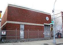
The Myrtle Avenue station closed on July 16, 1956 for the reconstruction of the flying junction north of DeKalb Avenue to increase capacity for the entire BMT Division.[19] The Brooklyn-bound platform was removed completely, but the Manhattan-bound platform still exists.[20]
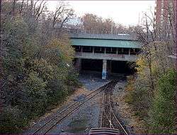
Formerly, the Fourth Avenue Line served trains from the BMT Culver Line, which connected to the 36th Street station via the lower level of the Ninth Avenue station south of Green-Wood Cemetery from a now-demolished elevated structure.[3] Following the connection of the Culver Line to the South Brooklyn Line of the IND in 1954, the only access to the line from the 4th Avenue subway was via the Culver Shuttle at Ninth Avenue. Shuttle service ended in 1975, with homes and housing developments erected over the right-of-way of the two demolished stations in the 1980s and again in the 2010s. The barest stub of the old elevated line is still visible at Ditmas Avenue.[21][22]
Chaining information
The Fourth Avenue Line is chained BMT F.
Station listing
| Station service legend | |
|---|---|
| |
Stops all times |
| |
Stops all times except late nights |
| |
Stops late nights only |
| |
Stops late nights and weekends only |
| |
Stops weekdays only |
| |
Stops rush hours only |
| Time period details | |
| Neighborhood (approximate) |
Station | Tracks | Services | Opened | Transfers and notes | |
|---|---|---|---|---|---|---|
| Montague Street Tunnel branch (N | ||||||
| Downtown Brooklyn | Court Street | local | N |
August 1, 1920 | 2 4 | |
| Jay Street–MetroTech | local | N |
June 11, 1924 | formerly Lawrence Street A F | ||
| Manhattan Bridge branch (B | ||||||
| Myrtle Avenue | local | June 22, 1915 | Closed on July 16, 1956; only Manhattan-bound platform remains | |||
| Tunnel and Bridge tracks merge | ||||||
| DeKalb Avenue | bridge, tunnel | B |
June 22, 1915 | 6 tracks; tunnel tracks and one set of bridge tracks stop at station; the other set of bridge tracks bypass through the middle | ||
| bridge & tunnel tracks stopping at DeKalb Avenue split to the BMT Brighton Line (B | ||||||
| Atlantic Avenue–Barclays Center | all | D |
June 22, 1915 | 2 B Connection to LIRR at Atlantic Terminal; Originally named "Pacific Street" | ||
| Park Slope | Union Street | local | D |
June 22, 1915 | ||
| Ninth Street | local | D |
June 22, 1915 | F | ||
| Prospect Avenue | local | D |
June 22, 1915 | |||
| Greenwood Heights | 25th Street | local | D |
June 22, 1915 | ||
| Sunset Park | 36th Street | all | D |
June 22, 1915 | ||
| split with BMT West End Line (D | ||||||
| 45th Street | local | N |
June 22, 1915 | |||
| 53rd Street | local | N |
June 22, 1915 | |||
| 59th Street | all | N |
June 22, 1915 | |||
| express tracks become BMT Sea Beach Line (N | ||||||
| Bay Ridge | Bay Ridge Avenue | local | R |
January 15, 1916[7] | ||
| 77th Street | local | R |
January 15, 1916[7] | |||
| 86th Street | local | R |
January 15, 1916[7] | |||
| Fort Hamilton | Bay Ridge–95th Street | local | R |
October 31, 1925[11][12] | ||
References
- ↑ ‹The template Cite BDE is being considered for deletion.› "Bold Schemes". Brooklyn Daily Eagle. Brooklyn, NY. June 4, 1892.
- 1 2 Marrero, Robert (2015-09-13). "469 Stations, 846 Miles" (PDF). B24 Blog, via Dropbox. Retrieved 2015-10-09.
- 1 2 3 4 5 6 "Brooklyn Subway Extension Plan: Fourth Ave. Line to 86th St., Tunnel to Staten Island, and Eventually a Through Route to Coney Island". nytimes.com. The New York Times. February 16, 1912. Retrieved 28 June 2015.
- ↑ "Fourth Ave. Subway Dirt Begins to Fly". nytimes.com. The New York Times. November 14, 1909. Retrieved 28 June 2015.
- ↑ "Bay Ridge Turns Out For Start of Subway". nytimes.com. The New York Times. October 27, 1912. Retrieved 28 June 2015.
- ↑ "Two Subway Branches Open Up New Era of Prosperity for Brooklyn and Queens". nytimes.com. The New York Times. June 27, 1915. Retrieved 28 June 2015.
- 1 2 3 4 Senate, New York (State) Legislature (1917-01-01). Documents of the Senate of the State of New York.
- ↑ Senate, New York (State) Legislature (1917-01-01). Documents of the Senate of the State of New York.
- ↑ "Public Service Commission Promises To Complete Contract Awards This Year". Brooklyn Daily Eagle. January 16, 1916. Retrieved November 5, 2016 – via Nespapers.com.
- ↑ "Subway Running To Eighty–Sixth Street Starts Building Boom In Bay Ridge". Brooklyn Daily Eagle. January 15, 1916. Retrieved November 5, 2016 – via Newspapers.com.
- 1 2 "Subway Bids Announced: For 95th Street Terminal, Brooklyn, and Corona Yard". nytimes.com. The New York Times. March 1, 1925. Retrieved 28 June 2015.
- 1 2 "95th St. Subway Extension Opened At 2 P. M. Today". Brooklyn Daily Eagle. October 31, 1925. Retrieved 29 June 2015 – via Newspapers.com.
- ↑ "To Extend Subway to Fort Hamilton". nytimes.com. The New York Times. August 26, 1922. Retrieved 27 June 2015.
- ↑ "To Act This Year on the Richmond Tube: Route Approved in 1912 Still Alive-May Soon Be Adopted Anew or Amended". nytimes.com. The New York Times. February 13, 1919. Retrieved 27 June 2015.
- ↑ Martin, Douglas (November 17, 1996). "Subway Planners' Lofty Ambitions Are Buried as Dead-End Curiosities". nytimes.com. The New York Times. Retrieved 27 June 2015.
- ↑ Staten Island Rapid Transit; The Essential History, by Irvin Leigh and Paul Matus; Page 9 (The Third Rail Online)
- ↑ Levine, Richard (December 22, 1986). "S.I. TRAINS UNDERGOING RENOVATION". nytimes.com. The New York Times. Retrieved 27 June 2015.
- ↑ "Annual Report of the Brooklyn Rapid Transit Co. for The Year Ending June 30, 1912" (PDF). bmt-lines.com. Brooklyn Rapid Transit Company. June 30, 1912. Retrieved 4 March 2016.
- ↑ Joseph Brennan (2002). "Abandoned Stations : Myrtle Avenue". Retrieved 2010-09-09.
- ↑ "BMT Fourth Avenue Line - Myrtle Avenue". nycsubway.org. Retrieved 2010-09-09.
- ↑ Klein, Helen (July 6, 2010). "Board backs housing on former Culver Shuttle land". nypost.com. New York Post. Retrieved 28 June 2015.
- ↑ Daley, Jessica (June 13, 2012). "The Culver Shuttle: Lost Beneath Borough Park for 40 Years". ny.curbed.com. Curbed. Retrieved 28 June 2015.
| Services |
|      | ||||||
|---|---|---|---|---|---|---|---|---|
| Stations | ||||||||
| Divisions | ||||||||
| Other lists | ||||||||
| Expansion | ||||||||
| History | ||||||||
| Infrastructure | ||||||||
| Arts and culture | ||||||||
| Miscellaneous | ||||||||
| Other rapid transit in NYC | ||||||||