Fourth Avenue (Brooklyn)
| Location | Brooklyn |
|---|---|
| north end | Flatbush Avenue in Downtown Brooklyn |
| Major junctions |
|
| south end |
|

Fourth Avenue is a major thoroughfare in the New York City borough of Brooklyn. It stretches for 6 miles (9.7 km) south from Times Plaza, which is the triangle intersection created by Atlantic and Flatbush Avenues in Downtown Brooklyn, to Shore Road and the Belt Parkway in Bay Ridge.
While southwestern Brooklyn is well served by expressways, Fourth Avenue provides an alternate for local traffic as it directly links the neighborhoods of Park Slope, Sunset Park and Bay Ridge with Downtown Brooklyn. Traffic signals along the avenue are coordinated for green wave in the peak direction.
The avenue was paved in the 1890s as a grand parkway resembling the later Park Avenue in Manhattan, and rebuilt after 1910 for more traffic. [1]
North to south
Fourth Avenue begins at Times Plaza, the triangle intersection it forms with Flatbush and Atlantic Avenues at the foot of the Williamsburgh Savings Bank Tower and Atlantic Terminal in Downtown Brooklyn. The avenue extends south with three traffic lanes in each direction and a one-lane-wide concrete divider that provides a left-turn lane. The concrete divider is actually part of the ventilation system for the BMT Fourth Avenue Line, which lies directly underneath. While six lanes are provided, only four lanes get full use, since the outer two are used by double-parked vehicles and as a right-turn lane.[2]
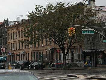
On its course through Park Slope, Fourth Avenue is home to several condominiums and homes but is dominated by service stations and automotive repair centers.
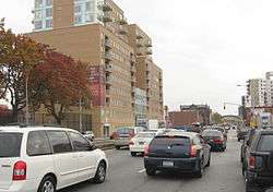
Upon entering Sunset Park, Fourth Avenue passes under the Prospect Expressway (NY 27) and offers indirect access to it through local side streets. The avenue continues to serve the automotive trade as far as the street numbered in the low 40s, where it becomes flanked by large wall-to-wall apartment buildings.[2]
After crossing under the Gowanus Expressway viaduct into Bay Ridge, the arterial boulevard gives way to a four-lane street bordered by four- to five- story apartment buildings until it reaches Shore Road and the Belt Parkway under the Verrazano Narrows Bridge.[2]
Churches

The borough has a thoroughfare named Church Avenue (named for an 18th century church), which, contrary to its name, does not rival the large number of later churches located along Fourth Avenue. At Fourth Avenue's intersection with 54th Street in Sunset Park, there are four houses of worship either directly at the corner of the intersection or within a building of it. Two of the churches stand side by side.[3]
Public transportation
As stated, the BMT Fourth Avenue Line (D N R trains) of the New York City Subway runs the length of Fourth Avenue. Stations are located at Atlantic Avenue, Union Street, Ninth Street, Prospect Avenue, 25th Street, 36th Street, 45th Street, 53rd Street, 59th Street, Bay Ridge Avenue, 77th Street, 86th Street, and 95th Street, with express stations at Atlantic Avenue, 36th Street, and 59th Street.[4]
MTA Regional Bus Operations operates several routes, none of which serve the avenue significantly. The B103 Limited route has the longest stretch, traveling southbound on 4th Avenue from Atlantic Avenue to Prospect Expressway. The B4, B9, B11, and B70 also use the avenue for short stretches. B1, B8, B16, B37, B63, S53, S79 SBS, and S93 buses also stop at the south end of the avenue.[5]
References
| Wikimedia Commons has media related to 4th Avenue (Brooklyn). |
- ↑ "From Grand Parkway to Canyon of Mediocrity, the Story of Brooklyn's Fourth Avenue". Curbed NY. Retrieved 2015-10-30.
- 1 2 3 Cartography from Google Maps
- ↑ Going Fourth, Forgotten NY
- ↑ "Subway Map" (PDF). Metropolitan Transportation Authority. November 2016. Retrieved 2016-11-07.
- ↑ Brooklyn bus map
Coordinates: 40°39′00″N 74°00′32″W / 40.65000°N 74.00889°W