Adams Township, Warren County, Indiana
| Adams Township | |
|---|---|
| Township | |
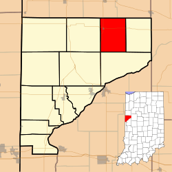 Location of Adams Township in Warren County | |
 Location of Indiana in the United States | |
| Coordinates: 40°26′28″N 87°14′41″W / 40.44111°N 87.24472°WCoordinates: 40°26′28″N 87°14′41″W / 40.44111°N 87.24472°W | |
| Country | United States |
| State | Indiana |
| County | Warren |
| Named for | John Quincy Adams |
| Government | |
| • Type | Indiana township |
| Area | |
| • Total | 26.99 sq mi (69.9 km2) |
| • Land | 26.99 sq mi (69.9 km2) |
| • Water | 0 sq mi (0 km2) |
| Elevation | 715 ft (218 m) |
| Population (2010) | |
| • Total | 512 |
| • Density | 19/sq mi (7/km2) |
| Time zone | Eastern (EST) (UTC-5) |
| • Summer (DST) | EDT (UTC-4) |
| GNIS feature ID | 453082 |
Adams Township is one of twelve townships in Warren County, Indiana. According to the 2010 census, its population was 512 and it contained 250 housing units.[1]
History
Adams Township was formed in 1848 and was named after the sixth president of the United States, John Quincy Adams.[2]
Geography
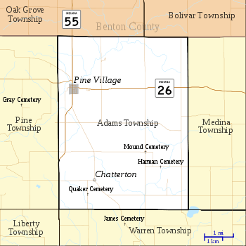
According to the 2010 census, the township has a total area of 26.99 square miles (69.9 km2), all land.[1] Its only town is Pine Village in the northwest part of the township, though a tiny hamlet named Chatterton stood southeast of Pine Village in the early part of the 20th century.[3]
Big Pine Creek enters the township from Benton County to the north and passes just to the northwest of Pine Village and continues southwest, emptying into the Wabash River near Attica.[4]
Cemeteries
The township contains three cemeteries. Mound (or Round) Cemetery is about 4 miles southeast of Pine Village and is in the form of a mound about 30 feet (9.1 m) high; county roads 700 N and 600 E intersect here and form a circle around the mound.[5] Harman Cemetery is less than a mile further to the southeast.[6] Quaker Cemetery is southwest of Chatterton.[7][8]
Transportation
Two highways, Indiana State Road 26 and Indiana State Road 55, intersect in Pine Village; State Road 26 begins at the Illinois border and continues east to Lafayette in Tippecanoe County,[9] while State Road 55 enters from Attica to the south and continues north to Oxford in neighboring Benton County.[10]
Education
Adams Township is part of the Metropolitan School District of Warren County. It contains one of the three elementary schools in the county, located in Pine Village.[11]
Government
Adams Township has a trustee who administers rural fire protection and ambulance service, provides relief to the poor, manages cemetery care, and performs farm assessment, among other duties. The trustee is assisted in these duties by a three-member township board. The trustees and board members are elected to four-year terms.[12]
Adams Township is part of Indiana's 8th congressional district, Indiana House of Representatives District 26,[13] and Indiana State Senate District 38.[14]
References
- 1 2 "Population, Housing Units, Area, and Density: 2010 - County -- County Subdivision and Place -- 2010 Census Summary File 1". United States Census. Retrieved 2013-05-10.
- ↑ Warren County Historical Society 1966, p. 17.
- ↑ Warren County Historical Society 1966, pp. 17–18.
- ↑ "Big Pine Creek". Indiana Department of Natural Resources. Archived from the original on 15 October 2010. Retrieved 2010-10-30.
- ↑ "Mound Cemetery". Geographic Names Information System. United States Geological Survey. Retrieved 2011-01-27.
- ↑ "Harman Cemetery". Geographic Names Information System. United States Geological Survey. Retrieved 2011-01-27.
- ↑ "Quaker Cemetery". Geographic Names Information System. United States Geological Survey. Retrieved 2011-01-27.
- ↑ Warren County Historical Society 1966, p. 21.
- ↑ "State Road 26". Highway Explorer. Retrieved 2010-09-21.
- ↑ "State Road 55". Highway Explorer. Retrieved 2010-09-21.
- ↑ "Corporation Snapshot, M S D Warren County #8115". Indiana Department of Education. Retrieved 2011-01-27.
- ↑ "Government". United Township Association of Indiana. Retrieved 2011-01-06.
- ↑ "Indiana Senate" (PDF). State of Indiana. Retrieved 2013-12-02.
- ↑ "Indiana House Districts" (PDF). State of Indiana. Retrieved 2013-12-02.
- "Adams Township, Warren County, Indiana". Geographic Names Information System. United States Geological Survey. Retrieved 2009-09-24.
- United States Census Bureau TIGER/Line Shapefiles
Bibliography
- Goodspeed, Weston A. (1883). "Part II. History of Warren County". Counties of Warren, Benton, Jasper and Newton, Indiana. Chicago: F. A. Battey and Company. pp. 31–156. Retrieved 2010-09-19.
- Clifton, Thomas, ed. (1913). Past and Present of Fountain and Warren Counties Indiana. Indianapolis: B. F. Bowen and Company. pp. 201–335. Retrieved 2010-09-19.
- Warren County Historical Society (1966). A History of Warren County, Indiana. Williamsport, Indiana.
- Warren County Historical Society (2002). A History of Warren County, Indiana (175th Anniversary Edition). Williamsport, Indiana.
External links
 |
Oak Grove Township, Benton County | |
Bolivar Township, Benton County | |
| Pine Township | |
Medina Township | ||
| ||||
| | ||||
| Liberty Township | Warren Township |
Municipalities and communities of Warren County, Indiana, United States | ||
|---|---|---|
| Towns | ||
| Townships | ||
| Unincorporated communities | ||
| Ghost towns | ||