Medina Township, Warren County, Indiana
| Medina Township | |
|---|---|
| Township | |
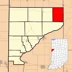 Location of Medina Township in Warren County | |
 Location of Indiana in the United States | |
| Coordinates: 40°26′12″N 87°08′27″W / 40.43667°N 87.14083°WCoordinates: 40°26′12″N 87°08′27″W / 40.43667°N 87.14083°W | |
| Country | United States |
| State | Indiana |
| County | Warren |
| Government | |
| • Type | Indiana township |
| Area | |
| • Total | 27.07 sq mi (70.1 km2) |
| • Land | 26.84 sq mi (69.5 km2) |
| • Water | 0.23 sq mi (0.6 km2) 0.85% |
| Elevation | 699 ft (213 m) |
| Population (2010) | |
| • Total | 457 |
| • Density | 17/sq mi (7/km2) |
| Time zone | Eastern (EST) (UTC-5) |
| • Summer (DST) | EDT (UTC-4) |
| GNIS feature ID | 453617 |
Medina Township is one of twelve townships in Warren County, Indiana, United States. According to the 2010 census, its population was 457 and it contained 191 housing units.[1]
History
Medina Township was one of the original four created when the county was organized in 1827.[2]
Geography
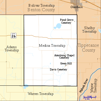
According to the 2010 census, the township has a total area of 27.07 square miles (70.1 km2), of which 26.84 square miles (69.5 km2) (or 99.15%) is land and 0.23 square miles (0.60 km2) (or 0.85%) is water.[1] It contains one town, Green Hill, which is in the southeast part of the township. The stream of Armstrong Creek runs through this township.
Cemeteries
The township contains Armstrong Chapel Cemetery, Davis Cemetery,[3] and Pond Grove Cemetery.[4]
Transportation
Indiana State Road 26 runs across the north part of the township from west to east, connecting Pine Village (in neighboring Adams Township to the west) with Lafayette to the east.[5]
Education
Medina Township is part of the Benton Community School Corporation
Government
Medina Township has a trustee who administers rural fire protection and ambulance service, provides relief to the poor, manages cemetery care, and performs farm assessment, among other duties. The trustee is assisted in these duties by a three-member township board. The trustees and board members are elected to four-year terms.[6]
Medina Township is part of Indiana's 8th congressional district, Indiana House of Representatives District 26,[7] and Indiana State Senate District 38.[8]
References
- 1 2 "Population, Housing Units, Area, and Density: 2010 - County -- County Subdivision and Place -- 2010 Census Summary File 1". United States Census. Retrieved 2013-05-10.
- ↑ Warren County Historical Society 1966, p. 42.
- ↑ "Davis Cemetery". Geographic Names Information System. United States Geological Survey. Retrieved 2011-02-05.
- ↑ "Pond Grove Cemetery". Geographic Names Information System. United States Geological Survey. Retrieved 2011-02-05.
- ↑ "State Road 26". Highway Explorer. Retrieved 2010-09-14.
- ↑ "Government". United Township Association of Indiana. Retrieved 2011-01-06.
- ↑ "Indiana Senate" (PDF). State of Indiana. Retrieved 2013-12-02.
- ↑ "Indiana House Districts" (PDF). State of Indiana. Retrieved 2013-12-02.
- "Medina Township, Warren County, Indiana". Geographic Names Information System. United States Geological Survey. Retrieved 2009-09-24.
- United States Census Bureau TIGER/Line Shapefiles
Bibliography
- Goodspeed, Weston A. (1883). "Part II. History of Warren County". Counties of Warren, Benton, Jasper and Newton, Indiana. Chicago: F. A. Battey and Company. pp. 31–156. Retrieved 2010-09-19.
- Clifton, Thomas, ed. (1913). Past and Present of Fountain and Warren Counties Indiana. Indianapolis: B. F. Bowen and Company. pp. 201–335. Retrieved 2010-09-19.
- Warren County Historical Society (1966). A History of Warren County, Indiana. Williamsport, Indiana.
- Warren County Historical Society (2002). A History of Warren County, Indiana (175th Anniversary Edition). Williamsport, Indiana.
External links
 |
Bolivar Township, Benton County | Shelby Township, Tippecanoe County | | |
| Adams Township | |
|||
| ||||
| | ||||
| Warren Township | |
Municipalities and communities of Warren County, Indiana, United States | ||
|---|---|---|
| Towns | ||
| Townships | ||
| Unincorporated communities | ||
| Ghost towns | ||