Al-Bad', Saudi Arabia
| Al-Bad' | |
|---|---|
 | |
| Highest point | |
| Coordinates | 28°39′15″N 35°18′21″E / 28.65417°N 35.30583°ECoordinates: 28°39′15″N 35°18′21″E / 28.65417°N 35.30583°E |
| Geography | |
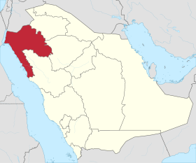
 Al-Bad' Location in Saudi Arabia | |
| Location | Saudi Arabia |
| Parent range | Sarwat Range |
Al-Bad', Saudi Arabia is a town in Tabuk provence of Saudi Arabia. It is west of Tabuk, Saudi Arabia, between Tabuk and the Red Sea Coast. Located at 28° 41' N and 35° 18'E It lies on the border of the Hejaz, and was in antiquity in Southern Midian. Al-Bad is located in the valley of the Wadi Aful in a highland area (218m ASL). It is near the town of Tajjib al-Ism and approx. 25 km east of the eastern coast of the Gulf of Aqaba, part of the Red Sea where there are pristine coral reefs. In 1995, 2 people at Al-Bad' were killed during the 1995 Gulf of Aqaba earthquake.[1]
Hijaz Mountains
To the east of the town is the Sarwat ranges, the northern end of the Hijaz Mountains. This area is known for Neolithic petroglyphs[2] carved into the arid volcanic rock. Northeast of the town is the peak Jabal al-Lawz,[3] (Arabic: جبل اللوز) which at 8400 feet is one of the highest peeks in Saudi Arabia. The mountain Jabal Maqla' is to the south of Jabal al Lawz. This 6000 foot high volcanic peak is, like Jabal Lawz, crowned with black basalt. Much of this volcanic region, is granite and vegetation is sparse grassland with the occasional tree.
Religious Signficance
The town of Al-Bad' is within the traditional Hejaz region of Saudi Arabia, and the population are Muslim. Some two kilometers south of the town of al-Bad' are caves called by the local people "Magha'ir Shu'ayb" (the Caves of Jethro). Modern archaeologists hold that the caves are, 1st century AD Nabatean tombs.
Local tradition also holds that "Bir al Saidni" located in the nearby coastal town of Makna,[4] is the very well from which Moses rolled away the stone to draw water for the flocks of Jethro's daughters. The town of Makna (or Magna) is on the Red Sea coast to the southwest of al-Bad'. A Jewish community at was known here from at least the 9th centuryAD.
The nearby town of Tajjib al-Ism is important to some Mormons as they believe it is referenced in the book of Mormon.
Evangelicals writers, Bob Cornuke, Ron Wyatt and Lennart Moller, hold that Jabal al-Lawz, is the real biblical Mount Sinai.
References
- ↑ Significant earthquakes of the World, 1995.
- ↑ Khan, M. 1991 Recent Rock Art and Epigraphic Investigations in Saudi Arabia. Proceedings of the Seminar for Arabian Studies 21: 113-118.
- ↑ Jabal Lawz.
- ↑ "MAKNA city map, MAKNA city road map, MAKNA city Guide, Latest News from Makna, Saudi Arabia". newstrackindia.com. Retrieved 2016-03-29.