Alameda Ridge
The Alameda Ridge is a large gravel bar located in Portland, Oregon, United States.
Geologic history
Alameda Ridge was formed between 15,000 and 13,000 years ago at the end of the last ice age when the ice dam containing Glacial Lake Missoula collapsed some 40 times, causing the Missoula Floods, some of the largest floods known on earth. The flood waters spilled across Idaho and eastern Washington, surged down the Columbia River and through the Gorge, flooding the Willamette Valley as far south as Eugene, Oregon. These floods covered the city of Portland, Oregon in approximately 400 feet (120 m) of water, carving out Sullivan's Gulch, the large ravine that holds Interstate 84, and depositing a large volumes of unconsolidated silt, sand, gravel, and boulders.[1][2] As the west-flowing waters rushed around Rocky Butte, a volcanic cinder cone in the Boring Lava Field, sediments were deposited on the west side of the butte forming an approximately 100 to 150-foot (46 m) high bar that became Alameda Ridge. The ridge extends west roughly 6 miles (9.7 km) from Rocky Butte to approximately 15th Avenue and Skidmore Street.
Human history
Portland residents began building on Alameda Ridge around the turn of the 20th century, as electric streetcars allowed real estate development to grow away from the city core. The steep hillside on the south side of the ridge provides beautiful views of Northeast Portland and the downtown skyline. This allowed early developers to cater to wealthy individuals, and many early real estate agreements contained "whites only" provisions.[3][4] Because the Ridge was developed before cars were the primary mode of transportation, many public stairways were built along the southern hillside to allow easier travel between neighborhoods.[5] These stairways are still present today and are maintained by the City of Portland. Alameda Ridge runs through the Madison South, Roseway, Rose City Park, Beaumont-Wilshire, Alameda, and Sabin Neighborhoods, with some of the most expensive homes (some being worth more than one million dollars) located along the upper edge of the southern slope in the Rose City Park, Beaumont, Alameda Neighborhoods.
Gallery
-
.JPG)
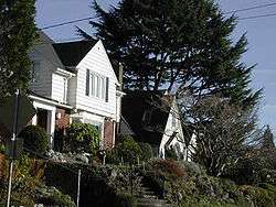
Typical view from Alameda Ridge looking towards downtown Portland from NE Alameda & NE 44th Avenue.
-
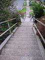
Stairway at 19th Ave.
-
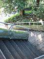
Stairway at 50th Ave.
-
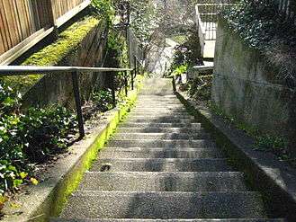
Stairway at 51st Ave.
-
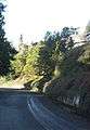
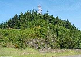
Alameda Ridge to the west from NE Wistaria Dr.
References
- ↑ Waymarking.com - "Missoula Flood Glacial Erratic, Tualatin, Oregon"
- ↑ USGS Cascades Volcano Observatory
- ↑ "Transportation Climbs Out of the Mud and Into the Clouds" - Randy Gragg, the Oregonian, May 12, 2005.
- ↑ "Alameda Ridge Bike Cruise" - Urban Adventure League, self-published
- ↑ "The Stairs of Alameda Ridge" - TatooineSky, YouTube Video.
External links
- Portland Neighborhood Map
- Northeast Neighborhoods - Portland Connected
| Ice Age Glacial Floods |  | |
|---|---|---|
| Glacial Lakes | ||
| Temporary Lakes | ||
| Ice Age Floods Glacial Residue | ||
| Ice Age Floods Erosion & Deposition Features | ||
| Related contemporaneous events | ||
Coordinates: 45°32′42″N 122°33′58″W / 45.54500°N 122.56611°W