Grand Coulee
| Grand Coulee | |
|---|---|
|
Grand Coulee, below Dry Falls. The layering effect of periodic basalt lava flows is visible. | |
 Map of Washington state | |
| Location | Washington state |
| Coordinates | 47°37′12″N 119°18′27″W / 47.62°N 119.3075°WCoordinates: 47°37′12″N 119°18′27″W / 47.62°N 119.3075°W |
| Designated | 1965 |
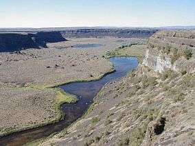
The Grand Coulee is an ancient river bed in the U.S. state of Washington. This National Natural Landmark[1] stretches for about 60 miles (100 km) southwest from Grand Coulee Dam to Soap Lake, being bisected by Dry Falls into the Upper and Lower Grand Coulee.
Geological History
The Grand Coulee is part of the Columbia River Plateau. This area has underlying granite bedrock, formed deep in the Earth's crust 40 to 60 million years ago. The land periodically uplifted and subsided over millions of years giving rise to some small mountains and, eventually, an inland sea.
From about 10 to 18 million years ago, a series of volcanic eruptions from the Grand Ronde Rift, near the Idaho/Oregon/Washington/Montana border began to fill the inland sea with lava. In some places the volcanic basalt is 6,600 feet (2.0 km) thick. In other areas granite from the earlier mountains is still exposed. Many animals roamed the area including camel, horse and rhinoceros.
Between two million years ago the Pleistocene epoch, glaciation took place in the area. Large parts of northern North America were repeatedly covered with glacial ice sheets, at times reaching over 10,000 feet (3,000 m) in thickness. Periodic climate changes resulted in corresponding advances and retreats of ice.
About 18,000 years ago a large finger of ice advanced into present-day Idaho, forming an ice dam at what is now Lake Pend Oreille. It blocked the Clark Fork River drainage, thus creating an enormous lake reaching far back into mountain valleys of western Montana. As the lake deepened, the ice began to float. Leaks likely developed and enlarged, causing the dam to fail. The 500 cubic miles (2,100 km3) of water in Lake Missoula, were released in just 48 hours—a torrential flood equivalent to ten times the combined flow of all the rivers in the world.
This mass of water and ice, towering 2,000 feet (610 m) thick near the ice dam before release, flowed across the Columbia Basin, moving at speeds of up to 65 miles per hour (105 km/h). The deluge stripped away soil, cut deep canyons and carved out 50 cubic miles (210 km3) of earth, leaving behind areas of stark scabland.
Over nearly 2500 years the cycle was repeated many times. Most of the displaced soil created new landforms, but some was carried far out into the Pacific Ocean. In Oregon's Willamette Valley, as far south as Eugene, the cataclysmic flood waters deposited fertile soil and icebergs left numerous boulders from as far away as Montana and Canada. At present day Portland, the water measured 400 feet (120 m) deep. A canyon 200 feet (61 m) deep is carved into the far edge of the continental shelf. The web-like formation can be seen from space. Mountains of gravel as tall as 40-story buildings were left behind; boulders the size of small houses and weighing many tons were strewn about the landscape.
Grooves in the exposed granite bedrock are still visible in the area from the movement of glaciers, and numerous erratics are found in the elevated areas to the northwest of the coulee.
Early theories suggested that glaciers diverted the Columbia River into what became the Grand Coulee and that normal flows caused the erosion observed. In 1910 Joseph T. Pardee described a great Ice Age lake, "Glacial Lake Missoula", a glacier dammed lake with water up to 1,970 feet (600 m) deep, in northwest Montana and in 1940 he reported his discovery that giant ripple marks 50 feet (15 m) high and 200–500 feet (61–152 m) feet apart had formed the lake bed. In the 1920s J Harlen Bretz looked deeper into the landscape and put forth his theory of the dam breaches and massive glacial floods from Lake Missoula.
Of the Channeled Scablands, Dry Falls, one of the largest waterfalls ever known, is an excellent example (south of Banks Lake).[2][3][4][5]
It is probable that humans were witnesses, and victims, of the immense power of the Ice Age Floods. Archeological records date human presence back to nearly the end of the Ice Age, but the raging torrents erased the land of clear evidence, leaving us to question who, if anyone, may have survived. With the end of the last glacial advance, the Columbia settled into its present course. The river bed is about 660 feet (200 m) below the Grand Coulee. Walls of the coulee reach 1,300 feet (400 m) in height.
Modern uses
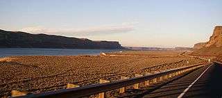
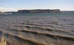
The area surrounding the Grand Coulee is shrub-steppe habitat, with an average annual rainfall of less than twelve inches (300 mm). The Lower Grand Coulee contains Park, Blue, Alkali, Lenore, and Soap lakes. Until recently, the Upper Coulee was dry.
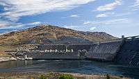
The Columbia Basin Project changed this in 1952, using the ancient river bed as an irrigation distribution network. The Upper Grand Coulee was dammed and turned into Banks Lake. The lake is filled by pumps from the Grand Coulee Dam and forms the first leg of a one-hundred-mile (160 km) irrigation system. Canals, siphons, and more dams are used throughout the Columbia Basin, supplying over 600,000 acres (240,000 ha) of farm land.
Water has turned the Upper Coulee and surrounding region into a haven for wildlife, including bald eagles. Recreation is a side benefit and includes several lakes, mineral springs, hunting and fishing, and water sports of all kinds. Sun Lakes and Steamboat Rock state parks are both found in the Grand Coulee. However, the lake has also flooded a large area of natural habitat and native hunting grounds, permanently displacing the indigenous people.
See also
References
- ↑ "Grand Coulee". nps.gov. National Park Service.
- ↑ Alt, David (2001). Glacial Lake Missoula & its Humongous Floods. Mountain Press Publishing Company. ISBN 0-87842-415-6.
- ↑ Bjornstad, Bruce (2006). On the Trail of the Ice Age Floods: A Geological Guide to the Mid-Columbia Basin. Keokee Books; San Point, Idaho. ISBN 978-1-879628-27-4.
- ↑ J Harlen Bretz, (1923), The Channeled Scabland of the Columbia Plateau. Journal of Geology, v.31, p.617-649
- ↑ Mueller, Ted and Marge (1997). Fire, Faults & Floods. University of Idaho Press, Moscow, Idaho. ISBN 0-89301-206-8.
External links
| Wikimedia Commons has media related to Grand Coulee. |
- The Geologic Story of the Columbia Basin, BPA site
- 3D images of the Grand Coulee, USGS site
- WDFW - Wildlife of Eastside Shrubland and Grassland Habitats
- University of Washington Libraries Digital Collections – Lawrence Denny Lindsley Photographs Includes 146 images (ca. 1938–1958) of the Columbia River, Eastern Washington and the Grand Coulee region.
- JSTOR - Geographical Review
| Ice Age Glacial Floods | 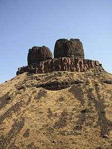 | |
|---|---|---|
| Glacial Lakes | ||
| Temporary Lakes | ||
| Ice Age Floods Glacial Residue | ||
| Ice Age Floods Erosion & Deposition Features | ||
| Related contemporaneous events | ||