Lake Condon
Lake Condon was a temporary lake in the Pacific Northwest region of North America, formed periodically by the Missoula Floods from 15,000 to 13,000 BC.
The restricted flow of waters[1] from cataclysmic floods from Glacial Lake Missoula, and pluvial Lake Bonneville through the constriction of the Wallula Gap in the Horse Heaven Hills flowed into south-central Washington and north-central Oregon, and were backed up by the Columbia River Gorge, forming Lake Condon. The water remained for a period of 5–7 days before the flood waters drained through the Columbia River Gorge. Lake Condon reached an elevation of about 1200 feet above sea level (today's sea level) before subsiding.[2][3][4]
Lake Condon also flooded the Umatilla, and John Day river valleys.[5]
Glacial Lake Missoula

During the last Ice Age (18,000 to 12,000 years ago), and in multiple previous Ice Ages, cataclysmic floods inundated portions of the Pacific Northwest from Glacial Lake Missoula, pluvial Lake Bonneville, and perhaps from subglacial outbursts. Glacial Lake Missoula was a body of water as large as some of the USA's Great Lakes. This lake formed from glacial meltwater that was dammed by a lobe of the Canadian ice sheet. Episodically, perhaps every 40 to 140 years, the waters of this huge lake forced its way past the ice dam, inundating parts of the Pacific Northwest. Eventually, the ice receded northward far enough that the dam did not reform, and the flooding episodes ceased.
Evidence for Lake Condon
Columbia River Gorge
Although the river slowly eroded the land over this period of time, the most drastic changes took place at the end of the last Ice Age when the Missoula Floods cut the steep, dramatic walls that exist today. The gorge provided a hydraulic dam which backed waters up for days before it drained.[6] This quick erosion left many layers of volcanic rock exposed.[7]
Touchet-like formation
Lake Condon backflooded into the Umatilla and John Day River Valleys. In these relatively calm arms of the lake, the slackwaters were thick with suspended materials eroded from the scablands above. Some of the suspended materials settled out, creating thick sediment layers which are found throughout these valleys.[8] These sediment layers are part of the Touchet Formation.[5]
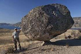
Glacial erratics
The maximum elevation of the flood, as established by other indications, is confirmed by glacial erratics, which were stranded on the slopes up the John Day and Umatilla river valleys and other elevated regions in the mid-Columbia at elevations of up to 1200 feet (366m) above sea level.[8]
References
- ↑ Flow was restricted by a hydraulic dam—a restriction to the flow rate caused by a narrowed reach in a river valley.
- ↑ United States Geological Service Site
- ↑ Ice Age Floods Institute site on Lake Lewis
- ↑ Bjornstad, Bruce (2006). On the Trail of the Ice Age Floods: A Geological Guide to the Mid-Columbia Basin. Keokee Books; San Point, Idaho. ISBN 978-1-879628-27-4.
- 1 2 Carson, Robert J.; Pogue, Kevin R. (1996). Flood Basalts and Glacier Floods:Roadside Geology of Parts of Walla Walla, Franklin, and Columbia Counties, Washington. Washington State Department of Natural Resources (Washington Division of Geology and Earth Resources Information Circular 90). ISBN none.
- ↑ The Seattle Times' Pacific NW magazine - "Trailing an Apocalypse" - 30 September 2007
- ↑ "Columbia River Gorge". Retrieved 2008-06-02.
- 1 2 Allen, John Eliot; Burns, Marjorie; Sargent, Sam C. (c. 1986). Cataclysms on the Columbia : a layman's guide to the features produced by the catastrophic Bretz floods in the Pacific Northwest. Portland, OR: Timber Press. ISBN 0881920673.
External links
- "Ice Age Floods Institute". Ice Age Floods Institute. Retrieved 18 April 2009.
- Bjornstad, B.N.; Fecht, K.R. (October 19, 2002). "Ice Age Floods Features in the Vicinity of the Pasco Basin and Hanford Reach National Monument" (PDF). Field trip guide for the biannual meeting of the Ice Age Floods Institute. Ice Age Floods Institute, Richland, WA. Retrieved 18 April 2009.
| Ice Age Glacial Floods | 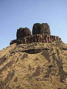 | |
|---|---|---|
| Glacial Lakes | ||
| Temporary Lakes | ||
| Ice Age Floods Glacial Residue | ||
| Ice Age Floods Erosion & Deposition Features | ||
| Related contemporaneous events | ||
Glacial erratics in Washington state | ||||||||
|---|---|---|---|---|---|---|---|---|
| Puget Sound |
|  | ||||||
| Elsewhere | ||||||||
| ||||||||
Coordinates: 45°55′9″N 119°21′20″W / 45.91917°N 119.35556°W