Foster Coulee
Foster Coulee is a coulee in Douglas County, Washington. Like the larger Moses Coulee nearby, it was formed during the Missoula Floods at the end of the last ice age, some 14,000 years ago.[1]
Washington State Route 17 between Bridgeport, Washington and Coulee City, Washington follows East Foster Creek along much of the coulee's valley floor.[2] East Foster Creek now flows east to west through Foster Coulee to Grand Coulee.[3]
The United States Geological Survey quadrangle map "Foster Coulee" is named for this prominent feature.[4]
Creation of the coulee
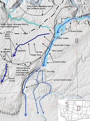
Foster Coulee was formed during the Missoula Floods.
The Okanogan lobe of the Cordilleran Glacier moved down the Okanogan River valley and blocked the ancient route of the Columbia River, backing up water to create Glacial Lake Columbia. Initially, floodwater discharged from Glacial Lake Columbia by running up through the head of Grand Coulee and down through Foster Coulee to rejoin the Columbia River. After the floods, meltwater from the glacier reversed course and flowed east through the coulee, forming a hanging valley above the west rim of Grand Coulee and a debris fan on the Grand Coulee floor that can be seen today. As the glacier moved further south, Foster Coulee was cut off and the Columbia River then discharged through Moses Coulee.[5]
Proposed reservoir
Foster Coulee has been studied as a potential pumped-storage hydroelectricity site.[6] The coulee would be dammed and approximately 500 MW generation capacity installed, exploiting the c. 500-foot (150 m) difference in elevation between the new reservoir and the existing Banks Lake.[7] Banks Lake is in turn created by pumping water 280 feet (85 m) uphill from the Columbia River at the Grand Coulee Dam.
Notable wildlife
The Washington Ground Squirrel, a candidate for U.S. Endangered Species Act listing, inhabits Foster Coulee.[8]
References
- ↑ Martin, Knud (June 2001), Late Pleistocene Glacial Lakes of Foster Creek Watershed, Washington (PDF), Central Washington University, Department of Geology
- ↑ Google (July 4, 2013). "State Route 17" (Map). Google Maps. Google. Retrieved July 4, 2013.
- ↑ Blanton, Paul (August 2004), "HISTORICAL ARROYO DEVELOPMENT IN THE WEST FOSTER CREEK WATERSHED, WASHINGTON: SPATIAL EXTENT, TIMING, CAUSES, AND MANAGEMENT IMPLICATIONS" (PDF), Master's Thesis, Central Washington University—Geography, retrieved 2013-07-03
- ↑ "FOSTER COULEE, WA", 1:24,000 quadrangle map, United States Geological Survey, 1968, ISBN 978-0-607-57173-8
- ↑ Mueller, Marge; Mueller, Ted (1997). Fire, Faults and Floods. Moscow, Idaho: University of Idaho Press. pp. 142–144. ISBN 0-89301-206-8.
- ↑ "Water storage feasibility studies" (PDF), The Conservation Voices, Foster Creek and South Douglas (County, Washington) Conservation Districts and United States Department of Agriculture Natural Resources Conservation Service, Winter 2009
- ↑ Anchor QEA, LLC (April 2010), WRIA 44/50 WATER STORAGE STUDY (PDF), Washington State Department of Ecology, retrieved 2013-07-03
- ↑ Finger, Rich; Wiles, Gary J.; Tabor, Jim; Cummins, Eric (2007), Washington Ground Squirrel Surveys in Adams, Douglas, and Grant Counties, Washington, 2004 (PDF), Washington Department of Fish and Wildlife
External links
- 47°54′45″N 119°21′53″W / 47.91250°N 119.36472°W—mouth
- 47°52′51″N 119°14′19″W / 47.88083°N 119.23861°WCoordinates: 47°52′51″N 119°14′19″W / 47.88083°N 119.23861°W—source
- U.S. Geological Survey Geographic Names Information System: Foster Coulee
| Ice Age Glacial Floods |  | |
|---|---|---|
| Glacial Lakes | ||
| Temporary Lakes | ||
| Ice Age Floods Glacial Residue | ||
| Ice Age Floods Erosion & Deposition Features | ||
| Related contemporaneous events | ||