Alexandria, South Dakota
| Alexandria, South Dakota | |
|---|---|
| City | |
 Location in Hanson County and the state of South Dakota | |
| Coordinates: 43°39′17″N 97°46′53″W / 43.65472°N 97.78139°WCoordinates: 43°39′17″N 97°46′53″W / 43.65472°N 97.78139°W | |
| Country | United States |
| State | South Dakota |
| County | Hanson |
| Founded | 1880 [1] |
| Incorporated | 1885[1] |
| Area[2] | |
| • Total | 0.62 sq mi (1.61 km2) |
| • Land | 0.62 sq mi (1.61 km2) |
| • Water | 0 sq mi (0 km2) |
| Elevation | 1,352 ft (412 m) |
| Population (2010)[3] | |
| • Total | 615 |
| • Estimate (2015)[4] | 623 |
| • Density | 990/sq mi (380/km2) |
| Time zone | Central (CST) (UTC-6) |
| • Summer (DST) | CDT (UTC-5) |
| ZIP code | 57311 |
| Area code(s) | 605 |
| FIPS code | 46-00820[5] |
| GNIS feature ID | 1253612[6] |
| Website | alexandriasd.com |
Alexandria is a city in Hanson County, South Dakota, United States. The population was 615 at the 2010 census. It is the county seat of Hanson County.[7]
History

In 1879, the community was founded with the name Clarksville.[8] Its post office was established in 1880, and the city later incorporated in 1885 as Alexandria.[1] The city was named after Alexander Mitchell.[9]
Geography
According to the United States Census Bureau, the city has a total area of 0.62 square miles (1.61 km2), all of it land.[2] Alexandria has been assigned the ZIP code 57311, and the FIPS place code 00820.
Demographics
| Historical population | |||
|---|---|---|---|
| Census | Pop. | %± | |
| 1900 | 680 | — | |
| 1910 | 955 | 40.4% | |
| 1920 | 965 | 1.0% | |
| 1930 | 688 | −28.7% | |
| 1940 | 746 | 8.4% | |
| 1950 | 714 | −4.3% | |
| 1960 | 614 | −14.0% | |
| 1970 | 598 | −2.6% | |
| 1980 | 588 | −1.7% | |
| 1990 | 518 | −11.9% | |
| 2000 | 563 | 8.7% | |
| 2010 | 615 | 9.2% | |
| Est. 2015 | 623 | [10] | 1.3% |
| U.S. Decennial Census[11] 2015 Estimate[4] | |||
Alexandria is part of the Mitchell, South Dakota Micropolitan Statistical Area.
2010 census
As of the census[3] of 2010, there were 615 people, 231 households, and 171 families residing in the city. The population density was 991.9 inhabitants per square mile (383.0/km2). There were 249 housing units at an average density of 401.6 per square mile (155.1/km2). The racial makeup of the city was 98.5% White, 0.5% Asian, 0.7% from other races, and 0.3% from two or more races. Hispanic or Latino of any race were 1.6% of the population.
There were 231 households of which 35.1% had children under the age of 18 living with them, 66.7% were married couples living together, 4.8% had a female householder with no husband present, 2.6% had a male householder with no wife present, and 26.0% were non-families. 23.8% of all households were made up of individuals and 9.9% had someone living alone who was 65 years of age or older. The average household size was 2.66 and the average family size was 3.11.
The median age in the city was 37.5 years. 28.3% of residents were under the age of 18; 6.3% were between the ages of 18 and 24; 26.5% were from 25 to 44; 26.3% were from 45 to 64; and 12.8% were 65 years of age or older. The gender makeup of the city was 49.8% male and 50.2% female.
2000 census
As of the census[5] of 2000, there were 563 people, 234 households, and 146 families residing in the city. The population density was 1,041.9 people per square mile (402.5/km²). There were 251 housing units at an average density of 464.5 per square mile (179.5/km²). The racial makeup of the city was 99.29% White, 0.18% Native American, 0.18% Asian, and 0.36% from two or more races. Hispanic or Latino of any race were 0.18% of the population.
There were 234 households out of which 32.5% had children under the age of 18 living with them, 58.5% were married couples living together, 3.4% had a female householder with no husband present, and 37.2% were non-families. 34.2% of all households were made up of individuals and 20.1% had someone living alone who was 65 years of age or older. The average household size was 2.41 and the average family size was 3.15.
In the city the population was spread out with 27.5% under the age of 18, 7.5% from 18 to 24, 27.5% from 25 to 44, 20.4% from 45 to 64, and 17.1% who were 65 years of age or older. The median age was 38 years. For every 100 females there were 102.5 males. For every 100 females age 18 and over, there were 94.3 males.
The median income for a household in the city was $31,875, and the median income for a family was $45,333. Males had a median income of $30,500 versus $19,500 for females. The per capita income for the city was $16,120. About 2.8% of families and 6.2% of the population were below the poverty line, including 3.8% of those under age 18 and 9.7% of those age 65 or over.
Notable people
- Martin Conlan, member of the South Dakota State Senate
- Henry Montgomery, member of the South Dakota House of Representatives
References
- 1 2 3 "SD Towns" (PDF). South Dakota State Historical Society. Retrieved 2010-02-10.
- 1 2 "US Gazetteer files 2010". United States Census Bureau. Archived from the original on 2012-01-24. Retrieved 2012-06-21.
- 1 2 "American FactFinder". United States Census Bureau. Retrieved 2012-06-21.
- 1 2 "Population Estimates". United States Census Bureau. Retrieved June 13, 2016.
- 1 2 "American FactFinder". United States Census Bureau. Archived from the original on 2013-09-11. Retrieved 2008-01-31.
- ↑ "US Board on Geographic Names". United States Geological Survey. 2007-10-25. Retrieved 2008-01-31.
- ↑ "Find a County". National Association of Counties. Archived from the original on 2011-05-31. Retrieved 2011-06-07.
- ↑ Federal Writers' Project (1940). South Dakota place-names, v.1-3. University of South Dakota. p. 21.
- ↑ Chicago and North Western Railway Company (1908). A History of the Origin of the Place Names Connected with the Chicago & North Western and Chicago, St. Paul, Minneapolis & Omaha Railways. p. 161.
- ↑ "Annual Estimates of the Resident Population for Incorporated Places: April 1, 2010 to July 1, 2015". Retrieved July 2, 2016.
- ↑ United States Census Bureau. "Census of Population and Housing". Archived from the original on May 11, 2015. Retrieved June 13, 2016.
External links
Municipalities and communities of Hanson County, South Dakota, United States | ||
|---|---|---|
| Cities | 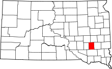 | |
| Towns | ||
| Unincorporated communities | ||