Algiers, New Orleans
| Algiers | |
| 15th Ward | |
| New Orleans Neighborhood | |
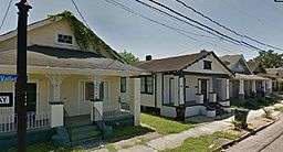 The corner of Vallette & Homer Streets in Algiers, New Orleans. | |
| Country | United States |
|---|---|
| State | Louisiana |
| City | New Orleans |
| Planning District | District 4, Algiers |
| Elevation | 0 ft (0.0 m) |
| Coordinates | 29°55′30″N 90°00′50″W / 29.92500°N 90.01389°WCoordinates: 29°55′30″N 90°00′50″W / 29.92500°N 90.01389°W |
| Area | 0.62 sq mi (1.6 km2) |
| - land | 0.62 sq mi (2 km2) |
| - water | 0.00 sq mi (0 km2), 0% |
| Population | 50,995 (2010) |
| Density | 82,250/sq mi (31,757/km2) |
| Founded | 1718 |
| Timezone | CST (UTC-6) |
| - summer (DST) | CDT (UTC-5) |
| Area code | 504 |
Algiers (/ælˈdʒɪərz/) is one of the oldest neighborhoods in New Orleans and the only Orleans Parish community located on the West Bank of the Mississippi River. Algiers is also known as the 15th Ward, one of the 17 Wards of New Orleans.[1]
History
Jean Baptiste le Moyne, Sieur de Bienville, was granted a large tract of land on the west bank of the river opposite New Orleans in 1719. This date is sometimes given as the year of the town's founding, making it one of the oldest neighborhoods in what is now New Orleans, but development as a town as opposed to a private plantation did not actually occur until about 1800. The name is believed to have come from the proximity to the city as compared to France and Algeria. Another theory is that a soldier returning from fighting in Algeria decided it looked just like that country when viewed from a ship.[2]
_001.jpg)
Others claim some connection to Arabs or Eqypt and Algeria and Tunisia in the far past for the area. Some Arab groups were and are related not only to North Africa and Moors, but also to Asia as well as India. Columbus reported flags on ships of other powers on some of his travels to the Americas. Towns in the South named Egypt or Little Egypt or Tunica are real. It is possible, even likely, that some of this tradition is real.
A powder magazine was built here for safety reasons and because it stood on higher ground. A slaughterhouse was also established and Algiers went by the name of Slaughterhouse Point for some time.
With the importation of African slaves in the 18th century, this area was used as a holding area until those who survived the sea voyage recovered enough to be dispatched across the river to be sold. Algiers was also a holding area for the Cajuns who survived the Great Upheaval, when the British expelled them from Nova Scotia.[2] The oldest part of Algiers is Algiers Point, across the river from the French Quarter.
The Duverjes built their plantation home in Algiers in about 1812. They would become the first family of Algiers and their home would later become the Algiers Courthouse. Algiers Point has been connected with the foot of Canal Street in downtown New Orleans by the Canal Street Ferry since 1827. It is one the oldest continuously operated ferry services in North America. Part of the Battle of New Orleans, in January 1815, was fought on the West Bank in what is now Algiers. Original earthworks remain, marked with a historical marker on General Meyer Avenue in the Aurora neighborhood. Much land in Algiers and elsewhere in south Louisiana was owned by John McDonogh, who was one of the world's largest private land owners until his death in 1850. His estate was willed to public schools in Baltimore and New Orleans.[3][4]
[5] McDonogh's home was located on the river south of Algiers point, but the land has since been washed away.[6] McDonogh's grave is in the McDonogh Cemetery in Gretna. Algiers was incorporated as a city in 1840. Shipbuilding was an important industry here.
In the 1850s, Algiers became a major railroad center and eastern terminus of the New Orleans, Opelousas and Great Western Railroad. Ferries were utilized for nearly a century to carry passengers, freight, and rail cars across the Mississippi River between the West Bank (including Algiers) and the East Bank (Central Business District of New Orleans).[7] Later, the railroad yard at Algiers would be the eastern repair shop for the Southern Pacific Railroad. The SPRR shop employed 4000 and had the capability to build mechanical parts for steamships.[6]
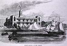
In April 1862, during the American Civil War, flames arose from the shipyards in Algiers as Confederate officials destroyed property that might benefit the invading Union troops. Historian John D. Winters, in his The Civil War in Louisiana (1963), notes that the New Orleans populace was "'amazed and could scarcely realize the awful fact, and ran hither and thither in speechless astonishment.' . . . Shocked out of their dumb disbelief, many people joined in the destruction. Cotton was rolled from the warehouses, ships loaded with produce were boarded, and fire was set to the lot. Crowds of the city poor broke open warehouses and carried away baskets, bags, and carts spilling over with rice, bacon, sugar, molasses, corn, and other foods. What they could not carry away they attempted to destroy by dumping in the river, burning, or throwing into the open gutters. A mob broke into the powder and gun factories in the Marine Hospital and carried away rifles and ammunition. The city was a frenzy of disorganized activity."[8]
In 1870, Algiers was annexed to the city as the 15th Ward, an arrangement which has remained although there have been repeated discussions of secession. Until the latter 1930s, rail yards housed large amounts of freight and rolling stock, which was brought back and forth across the Mississippi River by barge. Then, the Huey P. Long Bridge, which included a railway bridge, was built upriver at Bridge City, Louisiana. The largest railroad presence had been the Southern Pacific yard.[6] That location is still known to Algerines as "the SP yard." For decades it was largely a vacant strip. Portions of the tract were redeveloped for housing in the early 21st century. In the yard's active days, a steam-powered Southern Pacific train ferry brought railroad cars from there across the Mississippi River. The Algiers rail yards were known for their ability to repair or create replacements for any part needed for any type of locomotive and mechanical parts for ships.[6]

A fire destroyed most of the buildings in Algiers in 1895.[6] Most of the gingerbread-fronted houses seen in the neighborhood today date from the rebuilding that began almost immediately after that fire; although a small number of older buildings still survived. In 1901, the U.S. Navy established a naval station in Algiers. From 1966 until 2009, the site was one of the two campuses of the Naval Support Activity New Orleans base. Now the shuttered facility's West Bank campus is being redeveloped as a federal city. For centuries, intensive settlement in Algiers extended little beyond Algiers Point. The completion of the Greater New Orleans bridge across the Mississippi River in 1958 (now the Crescent City Connection) and the construction of Victory Drive (now General DeGaulle) and General Meyer Avenue made significant new development possible, and Algiers grew rapidly for the next 25 years.

An early history of Algiers is The Story of Algiers by William H. Seymour, published in 1896. The book was republished in 1971 and has been referenced in New Orleans and Louisiana histories.[6] An index of the book is online at the New Orleans Public Library website.[9]
Demographics
The Algiers neighborhood is predominately African American, with 89.4% of residents identifying as such in the 2000 Census.[10] Algiers' total population pre-Katrina, according to the census, was 28,385. 45.9 of that was male; 54.1 was female. The average age is 29.6 the population for children under 5 was 2,515. 18 and over was 19,204. 65 and over was 2,839. whites make up 21.8 of the population in Algiers Point, while African-Americans make up 73.6. Native Americans and Alaskan Natives are 0.2 of the population. Hawaiians barely registered, and Latino/as make up 4.3 percent. The average household size is 2.68; the average family size is 3.41. The total housing units in Algiers was 12,351. 83.9 of that is occupied, and 16.1 is vacant. 40.6 of those units are owned by home owners, while 59.4 are rented. Socially speaking, 72.3% are high school graduates, and 14.3% hold at least a Bachelor's degree. The married population is 41.2 percent male, and 33.2 are female. Families that are below the poverty level are at 30.3%; individuals below the poverty level are 35.3%.[11]
Poverty
Algiers suffers from a high poverty rates: Between 14.3 percent and 40 percent in most census blocks, according to the most recent federal data collected between 2007 and 2011 and assessed by The Data Center, an organization that researches community demographics in Southeast Louisiana.[12] The 70114 section of Algiers is among the lowest income neighborhoods in America, below 91.3% of U.S. neighborhoods. With 54.4% of the children here below the federal poverty line, it also has a higher rate of childhood poverty than 92.5% of U.S. neighborhoods. While the 70131 zip code in Algiers contains affluent subdivisions such as English Turn, Woodland Heights, Packenham Oaks, Lakewoood, and Park Timbers.[10]
Crime
Statistically, parts of Algiers especially Berhman are notorious for high crime rates, violence and drug activity in the city. Before 2005, most of the crimes committed occurred in the deprived and run-down neighborhoods as well as in low income apartment complexes and Housing projects like the Fischer Projects, DeGaulle Manor complex, and Christopher Homes.[13] The neighborhoods where heavenly effected by the Crack Epidemic in the 1980s, which also lead to a spike in crime in the early 1990s. Crime increased 15% with a 12% increase in violent crimes and murder. In a 1993 article, it was stated that half the crimes committed where by youths age ranging from 14-20.[14] By 2012 crime began to spread into the middle income communities of Tall Timbers, Old Aurora and Garden Oaks. [15][16] In one month of 2014, Algiers had a total of 15 armed robberies, 20 shootings (two fatal), and 47 cases of simple battery.[17] By the end of 2015. Algiers murder rate jumped to 23 homicides,[18] the highest murder rate of any neighborhood in America.[19] Algiers is patrolled by New Orleans's 4th District police officers.[20]
Today
A number of New Orleans carnival krewes have their "dens" (warehouses where their floats are constructed and stored) in Algiers. Algiers Point was placed on the National Register of Historic Places in 1978 and designated a local historic district in 1994.[21] People from Algiers have traditionally been known as "Algerines". Noted Algerines have included jazz musicians Jimmy Palao, Red Allen and Emmett Hardy, and R&B singer Clarence "Frogman" Henry. Political figures from Algiers include State Representative Jeff Arnold and State Senators Francis C. Heitmeier (1988-2008) and his brother, David Heitmeier (since 2008).
Algiers is home to many churches. There are numerous Catholic and Baptist congregations. The oldest Lutheran congregation, Trinity Evangelical Lutheran Church, was founded in 1875.[22] Trinity's steeple was blown off by Hurricane Katrina in 2005. A Catholic congregation, as well as Methodist and Episcopalian congregations, are all on the Historic Register of New Orleans, and some Algiers churches are listed on the National Historic Landmark lists. There are two branches of the New Orleans Public Library located in Algiers.[23] The Cita Dennis Hubbell Branch was built in 1907 as the Pelican Avenue Branch, one of three Carnegie libraries in New Orleans. Following years of neglect and hurricane damage, the library's roof was found to be in imminent danger of collapse and the location was closed on May 2008.[24] The Hubbell Branch was temporarily located at the Algiers Courthouse Carriage House a few blocks away, until it re-opened in the summer of 2013 in the original Pelican Avenue location. The Algiers Regional Branch, two miles away, was a larger library built in 1966. This library was damaged extensively by Katrina. The building was demolished and a new library constructed, which opened in early 2013.[25]
The area upriver from the Point was historically known as McDonoghville (which extended into part of what is now Gretna). Downriver from the Point is the West Bank portion of Naval Support Activity New Orleans, the largest military installation in the Greater New Orleans area. Further downriver from this is the neighborhood of Aurora, lower Algiers (Cutoff, River Park) and further still, the English Turn area, which was not substantially developed until the late 20th century. On September 26, 2005, Algiers became the first major section of New Orleans to be reopened to residents after Hurricane Katrina. Although a number of buildings suffered wind damage from the storm, Algiers escaped the flooding which affected most of the East Bank.
Krewe of NOMTOC
The Krewe of NOMTOC (New Orleans Most Talked Of Club) began parading on the Westbank (Orleans Parish) in 1970. Their inaugural parade had six floats, six bands, six marching units, one horse group and a motorcycle squardron. Today, this all-black krewe is composed of 400 male and female riders, 26 floats, ten bands and a number of marching and riding groups. Throws include ceramic medallion beads, jug banks and their signature Jug Man dolls. Their most popular throws for the 2013 parade include: Medallion Tri-Color Bead, Stuffed Baseball, Lighted Medallion Bead, Velour Spear with Krewe Crest, Top Hat Bead with Gold Pearls. The Krewe suggests that the best spots for family viewing are Holiday Dr. and Gen. Meyer Ave. in front of Behrman Stadium or along Mardi Gras Blvd. or at the intersection of Nunez St. and Mardi Gras Blvd. The Krewe’s sponsor, The Jugs Social Club has a rich heritage of civic activism, regularly donating funds to local schools, youth groups, and social programs. Each year a group of academic honor students is selected as guest riders in the parade. [26]
Neighborhoods
Algiers contains many neighborhoods such as
- Algiers Point
- McDonogh
- Old Aurora
- New Aurora
- Lower Algiers (Cutoff, River Park)
- Whitney
- Behrman
- Fischer Housing Development
- Tall Timbers/Brechtel
- McClendonville
Education
Primary and secondary schools
Algiers is zoned to schools in the New Orleans Public Schools. The district has its headquarters in the Westbank area of Algiers.[27]
For the 2006-2007 school year, parents have a choice between the following NOPS operated schools:
- Benjamin Franklin Elementary School (K-8)
- Bethune Elementary School (K-8)
- McDonogh 35 High School
In addition, students may attend schools operated by the Algiers Charter Schools Association ()
The schools include:
- Martin Behrman Elementary School (K-8)- Algiers Point
- Dwight D. Eisenhower Elementary School (K-8)- Tall Timbers/Brechtel
- William J. Fischer Elementary School (K-8)- Fischer Development
- McDonogh #32 Elementary School (K-8)- McDonogh
- L.B Landry - O.P. Walker College and Career Preparatory High School - Old Algiers
- Algiers Technology Academy - Cutoff (formerly Julius Rosenwald Elementary)
The InspireNola Charter Schools operate
- Edna Karr High School- Old Aurora
- Alice M. Harte Elementary School (K-8)- Old Aurora
Crescent City Schools include
- Harriet Tubman Charter Elementary School
- Paul B Habans Elementary School
One campus of the International School of Louisiana (ISL) is in Algiers.[28]
Colleges:
- Our Lady of Holy Cross
- Delgado Community College
Notable people
- Henry "Red" Allen, jazz trumpeter and singer
- Jeff Arnold, departing state representative and 2015 candidate for state senator
- Gary Carter, Jr., incoming state representative to succeed Jeff Arnold
- Olaf Fink, educator and state senator from 1956 to 1972
- Memphis Minnie, blues singer and guitarist
- G-Slimm, rapper
- Joe Blakk, rapper
- Kendrick Lewis, NFL free safety for the Baltimore Ravens
- Tre-8, rapper
- Cyril Richardson, NFL guard for the Buffalo Bills
- Patricia Clarkson, actress
- Anthony Johnson, NFL defensive tackle for the New England Patriots
- Ray Nagin, Mayor of New Orleans
- Lou Sino, jazz trombonist and singer
- Mike Wallace, NFL wide receiver for the Baltimore Ravens
- Patrick Surtain, NFL counerback for the Kansas City Chiefs
- Herb Tyler LSU Tigers quarterback
- Sean Wallace Southern Louisiana Defensive Back #25
References in popular culture
- The climactic fight in the 1986 film No Mercy takes place in Algiers.[29]
- Algiers is the home of Neon Boudeaux (played by Shaquille O'Neal), in the 1994 film Blue Chips.[30][31]
- In 2014, Algiers was featured on NCIS: New Orleans season 2 episode 2.[32]
See also
- Algiers Point
- Canal Street Ferry
- History of New Orleans
- National Register of Historic Places listings in Orleans Parish, Louisiana
- Neighborhoods in New Orleans
- Wards of New Orleans
References
- ↑ http://nolaba.org/living-in-new-orleans-neighborhoods.aspx
- 1 2 http://algierspoint.org/AHS/history.html algierspoint.org "Algiers History"
- ↑ McDonogh, John (1851). The last will and testament of John McDonogh, late of MacDonoghville, state of Louisiana. New Orleans: Printed at the job office of The Daily Delta. LCCN 2002553168.
- ↑ Allan, William (1886). Life and Work of John McDonogh. Baltimore: I. Friedenwald. 152545752.
- ↑ Ciravolo, G. Leighton (2002). The legacy of John McDonogh. Lafayette LA: Center for Louisiana Studies, University of Louisiana at Lafayette. ISBN 1-887366-48-2.
- 1 2 3 4 5 6 Seymour, William H. (1971). The story of Algiers, 1718-1896. Gretna LA: Pelican Publishing Company. LCCN 71162346.
- ↑ Dixon, Bill (2009). Last Days of Last Island: The Hurricane of 1856, Louisiana’s First Great Storm. Lafayette, LA: University of Louisiana at Lafayette Press. ISBN 1-887366-88-1.
- ↑ John D. Winters, The Civil War in Louisiana, Baton Rouge: Louisiana State University Press, 1963, ISBN 0-8071-0834-0, p. 96
- ↑ "What's New in NUTRIAS". New Orleans Public Library. Archived from the original on May 13, 2005. Retrieved 2006-04-28.
- 1 2 http://www.neighborhoodscout.com/la/new-orleans/algiers/
- ↑ http://algierslouisiana.blogspot.com/2009/03/demogra.html
- ↑ http://america.aljazeera.com/articles/2015/5/26/new-orleans-battles-for-algiers.html
- ↑ http://www.nytimes.com/2003/07/11/us/new-orleans-struggles-with-a-homicide-rate-that-belies-its-size.html?_r=0
- ↑ https://news.google.com/newspapers?nid=KFIQUvoPKFAC&dat=19930401&printsec=frontpage&hl=en
- ↑ http://www.nola.com/crime/index.ssf/2012/09/rash_of_killings_plagues_algie.html
- ↑ http://neworleanscitybusiness.com/blog/2012/06/08/nola-version-of-tranquil-mayberry-copes-with-sporadic-crime/
- ↑ http://www.wwltv.com/story/news/local/orleans/2014/10/29/algiers-armed-robberies-raise-new-gang-concerns/18152813/
- ↑ https://www.google.com/maps/d/u/2/edit?authuser=2&mid=1IiU7y6ooQ9BvqZp_PlPNoEC-eG8
- ↑ http://www.news.com.au/world/north-america/australian-duo-shot-in-drug-deal-gone-wrong-were-headed-to-neighbourhood-riddled-with-crime-poverty/news-story/eed85468619c7b9dcc80e15a2bd4811d
- ↑ http://www.nola.com/crime/index.ssf/2014/03/nopd_4th_district_commander_tr.html
- ↑ National Register of Historic Places - Algiers
- ↑ Trinity Evangelical Lutheran Church
- ↑ Branches and Bookmobiles. New Orleans Public Library. Retrieved on March 31, 2010.
- ↑ Hubbell Library
- ↑ Hubbell Library
- ↑ http://www.mardigrasneworleans.com/schedule/parade-info/parades-notmc.html
- ↑ "Central Office Staff." New Orleans Public Schools. Retrieved on December 15, 2009.
- ↑ Tan, Sarah. "The International School of Louisiana opens in Harahan." Times Picayune. November 23, 2012. Retrieved on May 18, 2014.
- ↑ http://www.imdb.com/title/tt0091637/
- ↑ http://www.subzin.com/quotes/M1229316ff/Blue+Chips/-+Where+is+he+at%3F+-+Algiers.
- ↑ http://www.imdb.com/title/tt0109305/?ref_=rvi_tt
- ↑ http://www.imdb.com/title/tt4955872/
External links
| Wikimedia Commons has media related to Algiers, New Orleans. |
| Wikivoyage has a travel guide for Algiers, New Orleans. |
- Algiers Point Association
- Algiers Point Information and Links page
- Cita Dennis Hubbell Library
- City of New Orleans
- Southern Pacific Historical & Technical Society