Almora district
| Almora district अल्मोड़ा | |
|---|---|
| District | |
|
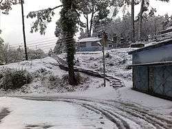
Ranikhet, Almora district | |
 Location in Uttarakhand, India | |
| Coordinates: 29°35′50″N 79°39′25″E / 29.59718°N 79.6570°ECoordinates: 29°35′50″N 79°39′25″E / 29.59718°N 79.6570°E | |
| Country |
|
| State | Uttarakhand |
| Division | Kumaon |
| Headquarters | Almora |
| Area | |
| • Total | 3,082 km2 (1,190 sq mi) |
| Elevation | 1,646 m (5,400 ft) |
| Population (2011) | |
| • Total | 621,927 |
| • Density | 205/km2 (530/sq mi) |
| Languages | |
| Time zone | IST (UTC+5:30) |
| PIN | 263601 |
| Telephone code | 91-5962 |
| Vehicle registration | UK-01 |
| Climate | Alpine (BSh) and Humid subtropical(Bsh) (Köppen) |
| Annual temperature | 28 to -2 °C |
| Summer temperature | 28 - 12 °C |
| Winter temperature | 15 to -2 °C |
| Website |
almora |
Almora district (Hindi: अल्मोड़ा जिला) is a district in the Kumaon division of Uttarakhand state, India. The headquarters is at Almora. It is 1,638 meters above sea level. The town of Almora is surrounded by Pithoragarh district to the east, Garhwal region to the west, Bageshwar district to the north and Nainital district to the south.
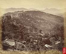
The hill station of Almora is situated on a horseshoe-shaped ridge of a mountain, the eastern portion of which is called Talifat and the western one is known as Selifat. The landscape of Almora attracts tourists each year for its views of the Himalayas, cultural heritage, handicrafts and cuisine, and is a business hub for the Kumaon region. Developed by the kings of Chand dynasty, it was later maintained and further developed by the British regime.
History
The ancient town of Almora, before its establishment, was under the possession of Katyuri king Baichaldeo. He donated the major part of this land to a Gujrati Brahmin Sri Chand Tiwari.[1] Later on when Chand kingdom was founded in Baramandal, the town of Almora was founded at this centrally located place in 1568[2] by Kalyan Chand. In the days of the Chand Kings it was called Rajapur. The name 'Rajpur' is also mentioned on a number of ancient copper plates.
In the 1960s Bageshwar district, Pithoragarh district and Champawat district had not yet been formed and were part of Almora district.[3]
Geography
The town of Almora is situated over a horse saddle-shaped ridge of a mountain. The eastern portion of the ridge is known as Talifat and the western one is known as Selifat. The market is at the top of the ridge where these two, Talifat and Selifat jointly terminate.
The market is 1.25 miles (2.01 km) long and is covered with stone slabs. The place of the present cantonment was formerly known as Lalmandi. Presently where the collectorate exists, the 'Malla Mahal' (Upper Court) of Chanda kings was located. The site of present District Hospital used to be 'Talla Mahal' (Lower Court) of Chand rulers.
Simalkhet is a village situated in the border of Almora and Chamoli. People of this village can speak both kumauni and garhwali languages. On the top of a hill there is a temple called Bhairav Gadi.
Gori River flows through Almora District.

Visitor attractions
- Chitai Temple, 10 kilometres (6.2 mi) from the main city of Almora, is dedicated to the Hindu deity Golu Devata, The God of Justice, popular in Kumaon region. An incarnation of the Lord Shiva, he is traditionally thought to fulfill wishes if prayed with a clear conscience.
- Nanda Devi Temple is a Hindu temple to the Goddess Nanda Devi in the center of the town, with unusual image carving on the temple walls. Nanda Devi festival is held annually in September.
- Bright End Corner, 2 kilometres (1.2 mi) from the main city of Almora, is a beauty spot visited at sunrise and sunset. A circuit house, Swami Vivekanand Memorial and Vivekanand Library is also situated here.
- Binsar Mahadev Temple was built around the 9-10 century A.D. It is believed locally to have been built in a single day. Ladies come here on Vaikunth chaturdashi and light a lamp on their palm to fulfill the desire of child. Binsar Mahadev is 19 kilometres (12 mi) from Ranikhet, and is surrounded by thick forests at an altitude of 2,480 metres (8,140 ft). It is known for its archeological significance and its dense forest.
- Lal Bazaar is a shopping centre for local crafts, woolen garments, decorative items and metal utensils.
- Someshwar, 35 kilometres (22 mi) from Almora city is famous for its ancient Lord Shiva Temple, constructed by Raja Som Chand during the Chand Dynasty.
- Jageshwar is known for its Shiva temple within a dense forest. The temple complex has 124 shrines and hundreds of statues.
Administrative subdivisions
District of Almora is divided into nine tehsils: Almora, Bhikiyasain, Chaukhutiya, Dwarahat, Jainti, Ranikhet, Someshwar, and Sult.
Its Assembly constituencies are Dwarahat, Salt, Ranikhet, Someshwar (SC), Almora, and Jageshwar.
Culture and literature
Almora was also the site of the dance academy set up by Udai Shankar, danseuse, in 1938 – several well-known Indian and French dancers trained there. The Almora dance academy was housed in Pine Lodge on the outskirts of the town (Ranidhara). The site has views of the Himalayas and the city.
"In these hills, Nature’s hospitality eclipses all that man can ever do. The enchanting beauty of the Himalayas, their bracing climate and the soothing green that envelops you, leave nothing more to be desired. I wonder whether the scenery of these hills and the climate are to be surpassed, if equalled, by any of the beauty spots of the world. After having been for nearly three weeks in the Almora hills, I am more than ever amazed why our people need to go to Europe in search of health."[4]
- Mahatama M.K. Gandhi
"These mountains are associated with the best memories of our race: Here, therefore, must be one of centers, not merely of activity, but more of calmness of meditation, and of peace and I hope some one to realize it."- Swami Vivekananda (replying to the address given to him by the people of Almora)
Transport
The Nearest airports to Almora are Pantnagar Airport (127 km) in Nainital and Naini Saini Airport (125 km) in Pithoragarh.
The nearest railway station is at Kathgodam, 90 km, from where direct trains are available for Delhi, Lucknow and Agra. Some of the major trains from Kathgodam are:
- Sampark Kranti Express (5035/506)
- Howrah Express (3019/3020)
- Ranikhet Express (5013/5014)
- Rampur Passenger (1/2 R.K. Passenger and 3/4 R.K. Passenger)
- Naintial Express (5308/5307)
- Garib Rath (weekly)
Almora is well connected by road to important centres in the region. NH 87 passes through to almora is known as karnaprayag national highway. Some distances:
- Delhi (378 km)
- Dehradun (394 km)
- Bageshwar (74 km), (92 km via Kausani)
- Nainital (63 km) (via Ranikhet 103 km)
- Kathgodam (86 km)
- Haldwani (91 km)
- Ramnagar (120 km), (via Nainital- 150 km)
- Rudrapur (130 km)
- Ranikhet (45 km)
- Dwarahat (68 km)
- Pithoragarh (120 km)
- Lucknow (454 km)
- Bareilly (191 km)
- chaukhutia (93 km)
Demographics
According to the 2011 census Almora district has a population of 621,927,[5] roughly equal to the nation of Montenegro[6] or the US state of Vermont.[7] This gives it a ranking of 517th in India (out of a total of 640).[5] The district has a population density of 198 inhabitants per square kilometre (510/sq mi).[5] Its population growth rate over the decade 2001-2011 was −1.73%.[5] Almora has a sex ratio of 1142 females for every 1000 males,[5] and a literacy rate of 81.06%.[5]
Hindus 621,203, Muslims 7,283 (1.15%), Christians 959. Most of the population lives near the main market of almora that forms nearly 45% of the population.[8]
In 2012 Almora city census 1,00,000 and area of city is 20.2 km2
Notable people
- Manohar Shyam Joshi (1933–2006), writer; born in Almora.[9]
- Sumitra Nandan Pant, writer; born in Almora.[9]
- Bhairab Dutt Pande Former Cabinet Secretary of India and Governor of West Bengal, Punjab is a resident of Almora
- Prasoon Joshi, writer, lyricist`
- Murli Manohar Joshi (Former Human Resource Development Minister of India)
- Pandit Govind Ballabh Pant ( First chief minister of U.P)
References
- ↑ Kumaon Official website of Almora district
- ↑ Almora history
- ↑ Times World Atlas, 1967 Edition, Plate 30.
- ↑ "The Collected Works of Mahatma Gandhi Vol. 46: 12 May 1929 - 31 August 1929" (PDF)., p. 254
- 1 2 3 4 5 6 "District Census 2011". Census2011.co.in. 2011. Retrieved 2011-09-30.
- ↑ US Directorate of Intelligence. "Country Comparison:Population". Retrieved 2011-10-01.
Montenegro 661,807 July 2011 est.
- ↑ "2010 Resident Population Data". U. S. Census Bureau. Archived from the original on 2013-10-19. Retrieved 2011-09-30.
Vermont 625,741
- ↑ "Uttarakhand - Districts of India: Know India". National Portal of India. Archived from the original on 19 February 2009. Retrieved 2009-04-04.
- 1 2 WRITERS AND THEIR WORKS Foundation of SAARC Writers. Archived April 2, 2010, at the Wayback Machine.
- "Almora district". The Imperial Gazetteer of India, Vol. 5. Oxford at Clarendon Press. 1909. pp. 243–252.
External links
 |
Chamoli district | Bageshwar district | | |
| Pauri Garhwal district | |
Pithoragarh district | ||
| ||||
| | ||||
| Nainital district | Champawat district |