Ramnagar, Uttarakhand
| Ramnagar रामनगर | |
|---|---|
| city | |
| Nickname(s): Corbett City | |
 Ramnagar  Ramnagar Location in Uttarakhand, India | |
| Coordinates: 29°24′N 79°07′E / 29.40°N 79.12°ECoordinates: 29°24′N 79°07′E / 29.40°N 79.12°E | |
| Country |
|
| State | Uttarakhand |
| District | Nainital |
| Named for | Jim Corbett |
| Elevation | 345 m (1,132 ft) |
| Population (2011) | |
| • Total | 97,916 |
| Languages | |
| • Official | Hindi |
| Time zone | IST (UTC+5:30) |
| PIN | 244715 |
| Telephone code | 915947 |
| Vehicle registration | UK-04 |
| Website |
uk |
Ramnagar (Hindi: रामनगर) is a small town and municipal board in the Nainital district of Uttarakhand, India. It is located approximately 65 kilometres (40 mi) from Nainital, the headquarters of the district.
Ramnagar is the gateway to the Corbett National Park, the oldest national park and a famous tourist destination of India. Garjiya Devi Temple and Sitabani temple located nearby also attracts many visitors.
Geography[1]
Ramnagar is located at 29.40°N 79.12°E.
It has an average elevation of 345 metres (1,132 feet). Ramnagar is located at the foothills of the Himalayas on the bank of river Kosi. The town is well-known for being the gateway to Corbett National Park and draws lot of tourist attention because of its geographical location. Its proximity to Nainital which is a famous hill station of Northern India makes it even more popular. Ramnagar is the gateway to western Kumaon and Garhwal. It is also the commencement point of Kumaon Hills with the nearby town of Haldwani. Ramnagar is also famous for International "Litchi farming". There is a Kosi Barrage in Ramnagar where lot of migratory birds arrives in winter.
History[2]
The town was re-established and settled by Commissioner H. Ramsay in 1856–1884. During the British Rule tea gardens were developed in Ramnagar and nearby villages in Uttarakhand. But these tea gardens have been closed since a long time. Ramnagar is most visited for Corbett National Park named after the hunter turned conservationist Jim Corbett who played a key role in its establishment. It is the oldest national park in India which was established in 1936.
Visitor attractions
Corbett National Park
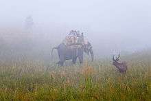
Corbett National Park is 10 km from Ramnagar. It is spread across 86 km north of Ramnagar. Established in 1936 as the Hailey National Park, Corbett National Park is the oldest and one of the most sought after national parks in India. It is India's first sanctuary to come under Project Tiger. The park was named after the hunter-naturalist turned author and photographer, Jim Corbett who lived in the region and contributed in setting up this park. Visitors can move about in vehicles (only local jypsies with the permit) inside the park area after making entries at the respective gates. Tourists now cannot drive their own cars inside Corbett. They have to hire jypsies with permits from Ramnagar. Permits are necessary for entering Corbett Tiger Reserve. Permits are issued at the CTR Reception Office at Ramnagar. Other places worth visiting in the region are the Crocodile Pool, Dhikala Machaan, Getheryo Library (Dhikala), Corbett Museum(Dhangadi gate), Corbett falls.
Garjiya Devi Temple
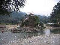
Garjiya Devi Temple is located in the Garjiya village near Ramnagar, Uttarakhand, India. It is a sacred Shakti shrine where Garjiya Devi is the presiding deity. The temple is situated over a large rock in the Kosi River and is one of the most famous temples of the Nainital district visited by thousands of devotees during Kartik Poornima, a Hindu holy day celebrated on the fifteenth lunar day of Kartik (November – December). It is also known as the festival of lights of the gods.[1] The Kartik Purnima festival also coincides with the Sikh festival of Guru Nanak Jayanti.
Sita Vani Temple
Seeta Bani Temple is dedicated to Devi Sita, consort of Lord Rama. It is believed that she entered into the lap of Mother Earth here. Every year, a fair is held here during Ramanavami. It is located at a distance of 20 km from Ramnagar.
Tumaria Dam
It is located about 17 km from Ramnagar in Maldhan village, it's a place to chill out and a major tourist attraction.
Accommodation
Ramnagar is also popular for having so many resorts for the tourists to accommodate. More than 100 resorts are located here.
Transportation
Air
The nearest airport is Pantnagar Airport, 81.6 km away via UT SH 41 and 77.3 km away via NH 87 in the town of Pantnagar in Udham Singh Nagar district. However Indira Gandhi International Airport at Delhi is the nearest international airport which is 269 km away.
Rail
In 1907, during the British Raj the railway line in Uttarakhand was extended from Moradabad to Ramnagar.[3] Ramnagar railway station is under the administrative control of the Izzatnagar division of the North Eastern Railway zone of the Indian Railways. The station is located about 65 km from Nainital. It has direct rail links to Kashipur, Moradabad, Delhi, Bareilly, Lucknow, Haridwar, Chandigarh, Gurgaon, Mumbai, Agra, Jaisalmer and Varanasi.Code of Ramnagar railway station is RMR
Road
Ramnagar bus station is located near to the Railway station. There are regular buses from Ramnagar to Nainital, Ranikhet, Haldwani, Haridwar , Dehradun, Kashipur, Moradabad , Meerut and Delhi. Bus services are also available to Jaipur. National Highway 121 which starts from Kashipur and ends at Bubakhal, Uttarakhand passes through Ramnagar.
References
- ↑ "Geography".
- ↑ "History".
- ↑ Sharad Singh Negi (1995). Uttarakhand: land and people. M.D. Publications Pvt. Ltd. ISBN 978-81-85880-73-0.